Situation Summary
Colombia remains at composite threat rank #29 globally with a score of 68, driven primarily by ongoing civil conflict and tracked across 362 events. The country faces concurrent risks: southwest corridor violence (bomb and drone attacks since late April); civil unrest tied to political transition (presidential election on 21 June completed; Congress opened 20 July; inauguration scheduled 7 August); and endemic urban crime in major cities. The trajectory is volatile but not acutely deteriorating; authorities have maintained operational tempo against armed groups, though incidents continue in high-risk southern departments.
Key Developments
GeoBit's event signals from 21–22 July 2026 indicate political and institutional activity rather than discrete security incidents:
- 21 July · Public statements and political signals – Multiple actors (government, Congress, Venezuela, FARC) issued public statements on 21 July; a congressman made a public statement; government-police coordination was publicly signaled. These reflect post-Congress political positioning rather than operational security events.
- 21 July · Civil unrest signals – Citizen demonstrations vs. Colombia and government-worker demonstrations were recorded, consistent with anticipated post-election/post-Congress civil unrest patterns in Bogotá and other major cities, though no specific location or casualty toll is specified in available timestamps.
- 21 July · FARC disapproval and government relations shift – FARC issued a disapproval statement and government announced reduced relations; Venezuela's public statement on the same date suggests regional dimension to political messaging.
- 22 July · Investigative and administrative activity – Government investigation vs. Senate and administrative sanctions were recorded, indicating post-transition institutional scrutiny but not direct security incidents.
- 21 July · Unspecified threat signal – A "Threaten" event was recorded with Colombia as the target, but source actor and subject matter are not specified in available data.
Note: Discrete, timestamped security incidents (attacks, kidnappings, arrests) within the 21–22 July window cannot be reliably identified from current web research. The broader pattern—southwest corridor bomb/drone activity (ongoing since late April), urban protest risk around political milestones, and endemic crime—remains the operational context.
Highest-Risk Areas
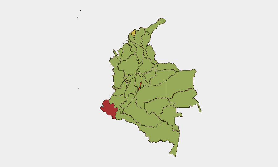
Nariño (77.7) and the Capital District (74.7) anchor the threat landscape. Nariño's rank reflects southwest corridor violence: bomb and drone attacks, armed-group activity, and narcotics-trafficking infrastructure concentrated in Cauca, Valle del Cauca, and Nariño departments since late April. The Capital District's rank reflects civil unrest, crime, and institutional vulnerability during political transition. Atlántico (69.3), Cundinamarca (59.7), and Valle del Cauca (59.0) round out the top five, driven by a combination of armed-group presence, narcotics trafficking, and urban crime. Antioquia, Santander, and Arauca remain elevated due to historical conflict dynamics and illicit-economy activity.
How GeoBit Would Assist
Security teams with personnel or assets in Colombia should employ AOI Monitoring & Early Warning on Nariño, Capital District, and the Panamericana corridor to detect bomb/drone activity and roadway disruption in real time. Intel Sweep and X/Twitter OSINT would track political messaging and threat signals around the 7 August inauguration window. Routing & Network Analysis and GIS & Spatial Analysis would support alternative journey planning away from high-risk southwest corridors and protest-prone urban zones. Persistent conflict event tracking and sentiment analysis on government-FARC and government-worker messaging would flag escalation or de-escalation signals ahead of major political dates.
7-Day Outlook
The 7 August presidential inauguration will be a focal point for both civil unrest (potential demonstrations and road disruption in major cities) and security-force deployment. Southwest corridor violence will likely continue at current tempo; no significant de-escalation is anticipated before inauguration. Risk to travel and outdoor movement in Bogotá and other major cities will remain elevated through the first week of August.
Highest-Risk Areas — Ranked
| # | State / Region | Risk |
|---|---|---|
| 1 | Nariño | 77.7 |
| 2 | Capital District | 74.7 |
| 3 | Atlántico Department | 69.3 |
| 4 | Cundinamarca Department | 59.7 |
| 5 | Valle del Cauca Department | 59 |
| 6 | Antioquia Department | 54.3 |
| 7 | Santander Department | 53.8 |
| 8 | Arauca Department | 53.4 |
| 9 | La Guajira | 49.6 |
| 10 | Bolívar Department | 49.1 |
| 11 | Magdalena Department | 48.7 |
| 12 | Caldas | 48.7 |
Previous Daily Briefs
A new Colombia brief is written every day — each with its own risk map and downloadable CSV. Here's the last week; use the calendar to go further back.
📅 Browse every day by calendar →
Highlighted days have a brief. Tap a day for that day's map & analysis, or “csv” for that day's dataset ($5).
Atlas — our AI intelligence desk — emails them this snapshot personally. Nothing else, no list.