Situation Summary
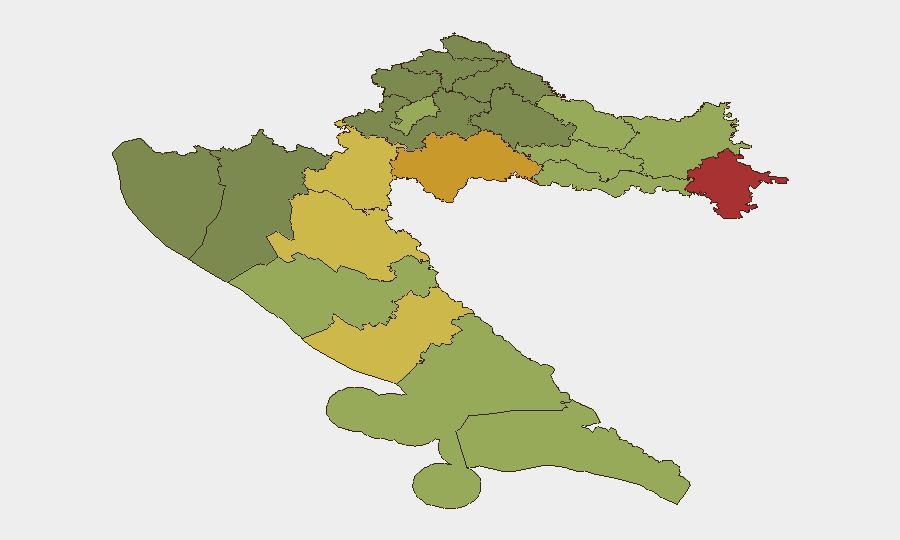
Croatia remains a low-threat environment globally (rank #149, composite score 7), with no tracked organized security events at the national level as of 24 August 2026. Recent activity consists of isolated incidents—aviation accident, weather-related flooding, arson arrests, and localized crime—rather than systemic instability or conflict. Eastern border regions (Vukovar-Srijem, Sisak-Moslavina, Karlovac counties) carry elevated composite risk scores driven by post-conflict legacy infrastructure vulnerabilities and cross-border dynamics, but pose no acute threat to operations. Overall trajectory remains stable.
Key Developments
- Ciovo Island / Trogir (24 August, ~11:45): Yacht fire with large black smoke plume visible across central Dalmatian coast; cause unknown, no reported casualties; localized port-area disruption.
- Paklenica National Park / Velebit (discovered 21 August, 22:00): German-registered ultralight (Diamond HK36) crashed in mountainous terrain ~60 km northeast of Zadar; two occupants deceased; search and rescue operation completed; aviation-safety incident, no broader civil implications.
- Zadar County roadside arson (arrests reported 18 August; fires set 14–15 August): Four suspects (three Croatian nationals, one foreign woman) arrested for deliberately setting fires at ten separate roadside locations; reflects ongoing wildfire-season arson enforcement.
- Drniš / Bobodol area (21 August): Canadian woman (28) arrested for alleged arson in open area; two additional suspects at large; part of broader Dalmatian fire-incident pattern.
- Varaždin violent assault (night of 21 August): 20-year-old male attacked by three assailants, kicked to head, knocked unconscious; no political motive indicated; reflects local violent-crime risk.
- Pula / Nord Stream case (detention ordered ~21 August; arrest 19 August): Ukrainian national detained on European arrest warrant as suspect in 2022 Nord Stream pipeline sabotage; extradition proceedings underway; high-profile security case with no local instability implications.
- Weather events (21 August): Severe thunderstorms across coastal regions caused flooding (>95 mm rainfall), affecting kindergartens, police facilities, homes, and moored vessels; roof damage in Lopar and downed trees in Rijeka; infrastructure resilience concern in affected localities.
Highest-Risk Areas
Eastern and border-proximate counties dominate the sub-national ranking: Vukovar-Srijem (78), Sisak-Moslavina (72), and Karlovac (68) reflect post-1990s conflict legacies—unexploded ordnance, aging infrastructure, cross-border smuggling routes, and Serbian-minority population dynamics. Lika-Senj and Šibenik-Knin counties (65 and 62 respectively) similarly reflect Dalmatian hinterland vulnerabilities. These rankings do not indicate active conflict but rather structural exposure (infrastructure decay, porous borders, historical tensions) that elevates baseline risk. Zagreb city-center risk (50) remains moderate and manageable for standard corporate operations.
How GeoBit Would Assist
Intel Sweep and multi-language OSINT (news, social media, Telegram channels) enable real-time detection of emerging incidents—as demonstrated by arson arrests and the yacht fire—before they propagate to wider disruption. AOI Monitoring & Early Warning with persistent watches on high-risk counties (Vukovar-Srijem, Sisak-Moslavina) and transport corridors would flag wildfire escalation, cross-border smuggling activity, or infrastructure incidents before asset impact. Routing & Network Analysis supports duty-of-care teams in planning alternative travel routes away from fire-affected zones and flood-prone areas, particularly in Zadar and coastal Dalmatia.
7-Day Outlook
Weather-related flood risk and wildfire season remain the near-term dominant threats through late August; arson arrests suggest law-enforcement control, but dry conditions and tourist season maintain fire hazard. Isolated violent crime and aviation incidents reflect normal statistical variation in a low-threat environment. No escalation expected absent geopolitical shock (regional conflict spillover, major border incident) or severe weather anomaly.
Highest-Risk Areas — Ranked
| # | State / Region | Risk |
|---|---|---|
| 1 | Vukovar-Srijem County | 78 |
| 2 | Sisak-Moslavina County | 72 |
| 3 | Karlovac County | 68 |
| 4 | Lika-Senj County | 65 |
| 5 | Šibenik-Knin County | 62 |
| 6 | Brod-Posavina County | 58 |
| 7 | Zadar County | 55 |
| 8 | Osijek-Baranja County | 52 |
| 9 | City of Zagreb | 50 |
| 10 | Split-Dalmatia County | 48 |
| 11 | Požega-Slavonia County | 45 |
| 12 | Virovitica-Podravina County | 42 |
Sources
Previous Daily Briefs
A new Croatia brief is written every day — each with its own risk map and downloadable CSV. Here's the last week; use the calendar to go further back.
- August 22, 2026
- August 20, 2026
- August 18, 2026
- August 16, 2026
- August 14, 2026
- August 12, 2026
- August 10, 2026
📅 Browse every day by calendar →
Highlighted days have a brief. Tap a day for that day's map & analysis, or “csv” for that day's dataset ($5).
Atlas — our AI intelligence desk — emails them this snapshot personally. Nothing else, no list.