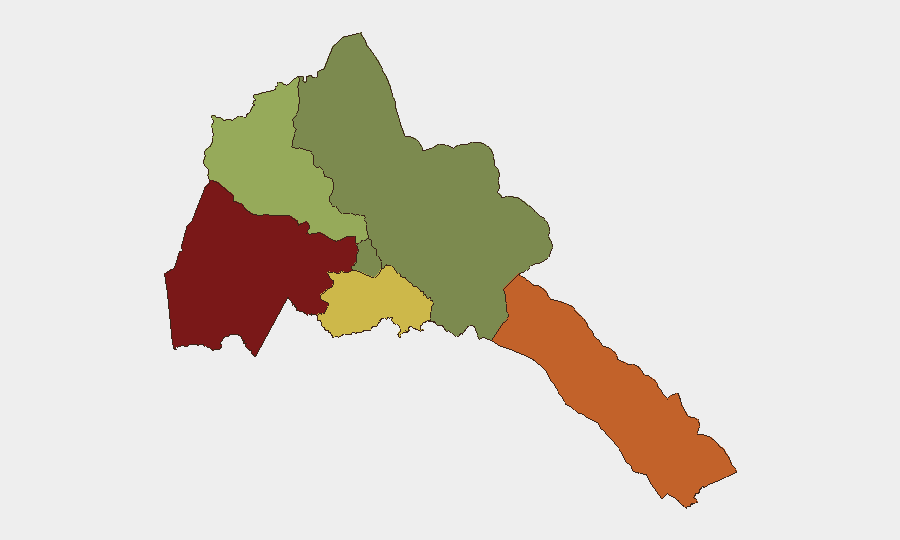
Situation Summary
Eritrea remains a low-transparency, authoritarian state with a composite threat score of 24 (global rank #75), reflecting overall relative stability in the national aggregate but concentrated subnational risk in border regions and the western lowlands. No discrete security incidents have been documented in Eritrea itself over the last 24–48 hours by available open sources. The threat environment is shaped primarily by chronic cross-border tensions with Ethiopia and Sudan, limited independent reporting capacity, and persistent restrictions on freedom of movement and media—factors that obscure real-time visibility into localized incidents.
Key Developments
No credible Eritrea-specific security incidents meeting criteria for recent (24–48 hour), clearly dated, multi-source confirmed reporting were identified in the current monitoring window. Open-source and social media searches yielded no discrete events—new conflict activity, civil unrest, crime incidents, infrastructure disruptions, or sudden changes in political stability—attributable to Eritrea in the last 48 hours. This reflects both the genuine scarcity of independent real-time reporting from Eritrea and the likelihood that lower-profile incidents may not surface in international feeds for days or weeks. Regional feeds occasionally reference Eritrea in cross-border or Horn of Africa contexts, but no such items met the timeframe and corroboration standard for inclusion here.
Highest-Risk Areas
Gash-Barka (risk 92) and the Southern Red Sea Region (risk 75) drive Eritrea's subnational threat profile, followed by the Debub Region (68). These western and southern zones border Sudan and Ethiopia respectively, where long-standing territorial disputes, militia activity, and sporadic armed clashes create persistent spillover risk. Anseba (55) also faces elevated exposure due to its proximity to Ethiopian and Sudanese border areas and limited state administrative capacity. By contrast, Maekel Region (18)—which includes the capital Asmara—and the Northern Red Sea Region (0) carry substantially lower assessed risk, reflecting greater central security presence and distance from active conflict zones. Organizations with personnel or assets in the high-risk western and southern regions should treat border-zone travel and operations as higher-friction activities.
How GeoBit Would Assist
A security team monitoring Eritrea should deploy AOI (Area-of-Interest) Monitoring & Early Warning over Gash-Barka and Southern Red Sea Region to detect emerging incidents before they propagate to mainstream reporting; Regional Conflict & Event Feeds (Horn of Africa, Sudan–Ethiopia cross-border) to capture incidents that implicate Eritrean forces or territory; and Travel Advisory Tracking combined with Satellite & Imagery Analysis to detect infrastructure damage, military movements, or humanitarian access changes. Network & Actor Analysis can help identify armed groups, militia leadership, and cross-border networks that pose direct risk to personnel and assets. Routing & Network Analysis supports alternative journey planning to avoid high-risk corridors and real-time border-area volatility.
7-Day Outlook
No acute escalation is signaled in the current 7-day outlook; however, the absence of reported incidents should not be conflated with absence of risk. Border-zone tensions with Sudan and Ethiopia remain structurally unresolved, and Eritrean military posture—particularly in Gash-Barka—remains a persistent factor. Organizations should maintain baseline vigilance and plan for slow-onset incidents (administrative restrictions, localized clashes, humanitarian access delays) rather than sudden, large-scale events.
Highest-Risk Areas — Ranked
| # | State / Region | Risk |
|---|---|---|
| 1 | Gash-Barka | 92 |
| 2 | Southern Red Sea Region | 75 |
| 3 | Debub Region | 68 |
| 4 | Anseba | 55 |
| 5 | Maekel Region | 18 |
| 6 | Northen Red Sea Region | 0 |
Sources
Previous Daily Briefs
A new Eritrea brief is written every day — each with its own risk map and downloadable CSV. Here's the last week; use the calendar to go further back.
- August 31, 2026
- August 29, 2026
- August 27, 2026
- August 25, 2026
- August 23, 2026
- August 21, 2026
- August 19, 2026
📅 Browse every day by calendar →
Highlighted days have a brief. Tap a day for that day's map & analysis, or “csv” for that day's dataset ($5).
Atlas — our AI intelligence desk — emails them this snapshot personally. Nothing else, no list.