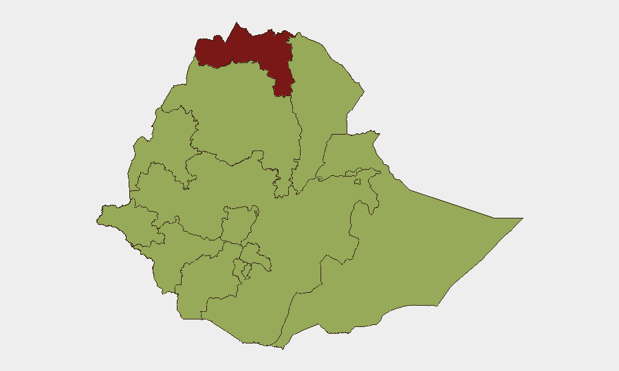
Situation Summary
Ethiopia remains in active civil conflict with a composite threat score of 84 (rank 12 globally), driven primarily by ongoing armed clashes between federal and Tigray forces. As of 2 August 2026, renewed heavy fighting in western Tigray signals military escalation after a period of relative de-escalation. The security environment is characterized by fragmented sub-national instability across multiple regions, intersecting with internal political demands and external regional pressure. Risk trajectory remains elevated and volatile, with potential for rapid localized deterioration.
Key Developments
- Western Tigray / Shererina (2026-08-02): Ethiopian National Defense Force (ENDF) and Tigray forces engaged in heavy armed confrontation following a reported federal military attack near the Sudan border. Tigray officials indicated fighting was ongoing at time of reporting; this represents a significant military escalation in the western corridor.
- Federal-Tigray Military Escalation (2026-08-02): Armed confrontations between ENDF and Tigray forces broke out overnight in western Tigray, characterized as a notable operational shift after months of relative ceasefire stability (since ceasefire agreements in 2025). Tactical drivers remain unclear from available open-source reporting.
- Government Pressure Incidents (2026-08-02): Multiple "demand" events logged between Ethiopian government entities and internal/external actors, indicating heightened diplomatic and institutional friction; Sudanese entities also logged demands against unspecified government targets, suggesting regional spillover.
- Arrests and Detention Activity (2026-08-01): Arrest/detention operations recorded; specific targets and locations not yet detailed in available sources but consistent with ongoing security operations.
- International Military Signaling (2026-08-02): Israeli-Ethiopian conventional military force contacts logged on two separate occasions, warrant monitoring for regional defense posture changes or joint operations planning.
- Media and Corporate Messaging (2026-07-31): Ethiopian government issued public statements directed at media and companies, tone of disapproval noted toward regional actors (Eritrea). Suggests information warfare and sanctions-related messaging.
Highest-Risk Areas
Tigray Region (88.5) remains by far the highest-risk zone, driven by active armed conflict and demonstrated capacity for rapid military escalation. Addis Ababa (63.8) carries elevated risk due to density of government, diplomatic, and corporate presence; security incidents there carry cascading institutional impact. The secondary cluster—Amhara, Afar, Benishangul-Gumuz, and Somali regions (all 58.5)—reflects endemic armed group activity, inter-communal tension, and limited state security reach. Oromia (58.5) and southern regional states warrant attention for banditry, protest activity, and periodic armed clashes. Risk is distributed but not uniform; Tigray and Addis Ababa demand prioritized duty-of-care attention.
How GeoBit Would Assist
Security teams should deploy AOI Monitoring & Early Warning on Tigray, western Tigray/Shererina corridor, and Addis Ababa to detect military movement and incident clusters in near-real time. Conflict & Military capabilities (battle mapping, force structure, weapons-capability tracking) provide tactical clarity on ENDF and Tigray force disposition and operational tempo. Multi-language OSINT and entity extraction (X/Twitter, Telegram, radio SIGINT) offer continuous monitoring of government statements, armed group communications, and humanitarian alerts to anticipate policy shifts or tactical changes.
7-Day Outlook
The Tigray fighting is likely to persist or intensify in the western corridor over the next 7 days, with risk of spillover into Amhara and Afar. Government messaging and international military signaling suggest sustained diplomatic and security posturing; expect continued rhetoric escalation. Organizations with personnel or assets in Tigray, Addis Ababa, and border regions should maintain heightened vigilance and contingency protocols.
Highest-Risk Areas — Ranked
| # | State / Region | Risk |
|---|---|---|
| 1 | Tigray | 88.5 |
| 2 | Addis Ababa | 63.8 |
| 3 | Amhara Region | 58.5 |
| 4 | Afar Region | 58.5 |
| 5 | Benishangul-Gumuz Region | 58.5 |
| 6 | Somali Region | 58.5 |
| 7 | Gambela Region | 58.5 |
| 8 | South West Ethiopia Peoples | 58.5 |
| 9 | South Ethiopia Regional State | 58.5 |
| 10 | Central Ethiopia Regional State | 58.5 |
| 11 | Oromia Region | 58.5 |
| 12 | Sidama | 58.5 |
Sources
Previous Daily Briefs
A new Ethiopia brief is written every day — each with its own risk map and downloadable CSV. Here's the last week; use the calendar to go further back.
📅 Browse every day by calendar →
Highlighted days have a brief. Tap a day for that day's map & analysis, or “csv” for that day's dataset ($5).
Atlas — our AI intelligence desk — emails them this snapshot personally. Nothing else, no list.