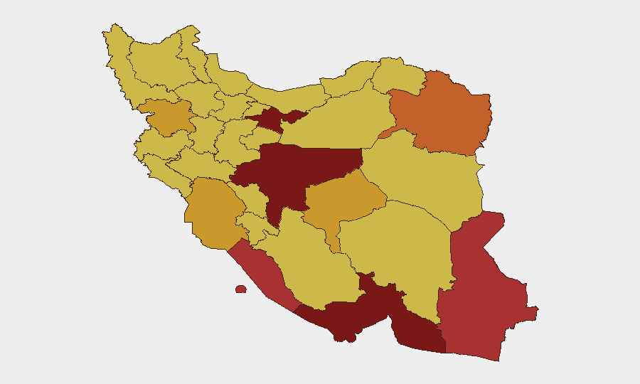
Situation Summary
Iran is experiencing an acute phase of direct military confrontation with the United States, marked by sustained U.S. airstrikes across the country and Iranian retaliatory missile and drone attacks on U.S.-aligned targets in the Gulf. Over 170 Iranian military targets have been struck in the past 48 hours, resulting in at least 14 confirmed deaths and 78 wounded across southern provinces, with critical infrastructure including the Bushehr Nuclear Power Plant perimeter now under direct threat. Iranian forces have responded with attacks on shipping in the Strait of Hormuz and cross-border strikes on U.S. bases in Bahrain and Kuwait, signaling escalation beyond Iran's borders.
Key Developments
- Bushehr Nuclear Facility, Bushehr Province – 9 Jul 2026: U.S. strikes struck the perimeter area of the Bushehr Nuclear Power Plant and adjacent military installations; local officials reported explosions and damage, with no immediate casualties reported at the plant itself but elevated risk of further targeting.
- Strait of Hormuz – 7–8 Jul 2026: IRGC attacked at least three commercial vessels including a Qatari LNG tanker (Al Rekayyat) and Saudi-flagged crude tanker, causing engine-room fires and damage; one vessel faced explosion risk, severely degrading maritime security in the waterway.
- Southern Iran Coastal and Military Targets – 8 Jul 2026: U.S. Central Command conducted strikes on approximately 90 Iranian military targets along the coastline, including air-defense systems, missile and drone storage, naval assets, and logistics infrastructure.
- Khuzestan Province and Iranshahr – 8–9 Jul 2026: Iranian Health Ministry reported at least three killed in Khuzestan and one firefighter killed at an airport in Iranshahr during U.S. airstrikes; broader casualty count across southern strike zones reached 14 dead and 78 wounded.
- Qeshm Island and Sirik, Hormozgan Province – 8 Jul 2026: Iranian state television reported explosions on Qeshm Island and the coastal city of Sirik following U.S. operations, confirming additional strike locations along the southern littoral.
- Bahrain – 9 Jul 2026: Bahrain's military reported Iranian missile and drone attacks targeting U.S. bases; authorities activated missile alert systems multiple times and characterized attacks as targeting civilian areas.
- Kuwait – 9 Jul 2026: Kuwaiti authorities reported incoming Iranian missiles and drones striking U.S. military installations in retaliation for U.S. strikes on Iran, compounding regional spillover effects.
Highest-Risk Areas
Tehran Province maintains the highest composite risk score (100), reflecting capital-city concentration of government, security, and strategic targets. However, the current escalation has shifted acute operational risk to southern and coastal provinces: Bushehr Province (77.9), Hormozgan Province (82.5), and Khuzestan Province (71) are experiencing active military strikes, air-defense engagements, and infrastructure damage. Bushehr's nuclear facility and Hormozgan's maritime zones present compounded hazard from both conventional strikes and potential secondary effects. Coastal areas from Qeshm Island to Sirik face heightened danger from ongoing maritime conflict and potential further U.S. targeting of Iranian military assets.
How GeoBit Would Assist
Security teams should deploy AOI Monitoring & Early Warning on critical facilities in Bushehr, Hormozgan, and Khuzestan to track strike patterns and air-raid alerts in near-real time. Maritime & Aviation Tracking combined with Conflict & Military battle-mapping capabilities would monitor shipping movements through the Strait of Hormuz, track IRGC naval activity, and assess ongoing strike operations. Routing & Network Analysis can identify safe transit corridors and alternative logistical pathways for personnel and cargo movement around active conflict zones.
7-Day Outlook
Escalation dynamics suggest sustained U.S. strikes on military infrastructure and potential Iranian follow-on attacks on Gulf shipping and regional bases over the next 5–7 days. No immediate ceasefire signals are evident; maritime interdiction risk in the Strait of Hormuz will remain severe. Personnel and asset exposure in southern provinces and coastal zones should be assessed for evacuation or hardened security posture.
Highest-Risk Areas — Ranked
| # | State / Region | Risk |
|---|---|---|
| 1 | Tehran Province | 100 |
| 2 | Isfahan Province | 88.2 |
| 3 | Hormozgan Province | 82.5 |
| 4 | Bushehr Province | 77.9 |
| 5 | Sistan and Baluchestan Province | 76.4 |
| 6 | Razavi Khorasan | 74.3 |
| 7 | Yazd Province | 71.8 |
| 8 | Kurdistan Province | 71.3 |
| 9 | Khuzestan Province | 71 |
| 10 | Fars Province | 70.9 |
| 11 | East Azerbaijan Province | 70.7 |
| 12 | Semnan Province | 70.5 |
Sources
Previous Daily Briefs
A new Iran brief is written every day — each with its own risk map and downloadable CSV. Here's the last week; use the calendar to go further back.
📅 Browse every day by calendar →
Highlighted days have a brief. Tap a day for that day's map & analysis, or “csv” for that day's dataset ($5).
Atlas — our AI intelligence desk — emails them this snapshot personally. Nothing else, no list.