Situation Summary
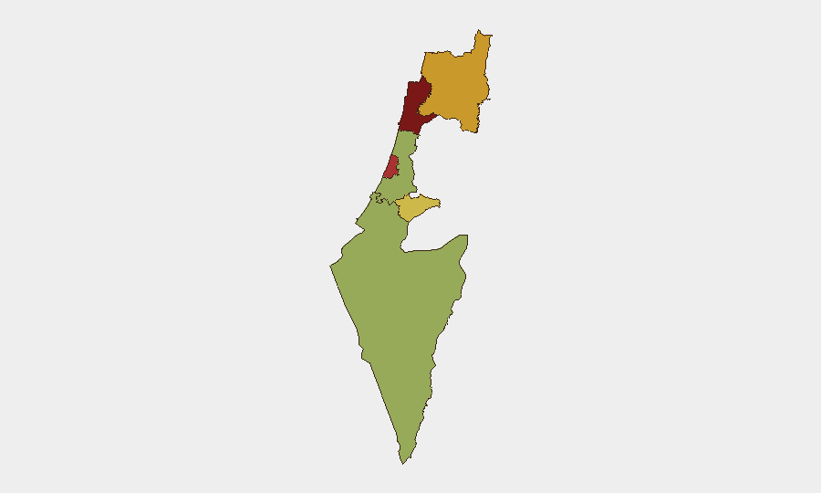
Israel faces elevated composite threat exposure (rank #15 globally, score 77) driven by concurrent military operations in Gaza, West Bank security sweeps, and early-warning signals of potential Hezbollah escalation along the northern border. Over the past 24–48 hours, routine operational activity has intensified—including raid operations in the West Bank, airstrikes in Gaza targeting rocket positions and militant infrastructure, and heightened IDF readiness along the Lebanon frontier. Haifa and Tel-Aviv districts remain highest-risk zones, reflecting both proximity to conflict zones and civilian concentration. Overall trajectory remains volatile but contained within existing operational patterns.
Key Developments
- Nablus, West Bank (2026-07-31 early hours): Israeli forces conducted a raid detention operation, apprehending approximately 40 Palestinians including former prisoners, as part of sustained counter-militant operations in the northern West Bank city.
- Deir Istiya, Salfit governorate (2026-07-31): Israeli settlers established a new outpost on Palestinian village land, escalating settler–Palestinian land-dispute friction in the central West Bank.
- Kerem Shalom crossing, Gaza–Israel border (2026-07-30 to 31): Two individuals attempted to approach or penetrate the crossing; one was detained. IDF confirmed no infiltration into Israeli territory occurred, though nearby communities received security alerts.
- Gaza airstrikes, multiple sites (2026-07-30 to 31): IDF overnight operations destroyed multiple rocket-launch positions and targeting infrastructure across the Gaza Strip, per operational summaries dated to the past 24–48 hours.
- Hatzerim airbase vicinity (2026-07-30 to 31): IDF strikes killed Palestinian Islamic Jihad militants suspected of a recent rocket attack on the airbase, according to Southern Command assessments within the past 24–48 hours.
- Northern border / Lebanon sector (2026-07-30 to 31): Israeli security assessments report heightened IDF readiness and ongoing low-intensity skirmishing along the Lebanese frontier, tied to signals of Hezbollah reorganization ahead of potential large-scale renewal of hostilities.
- Gaza operations, Khan Younis and northern sector (2026-07-30 to 31): IDF operational tallies report hundreds of Hamas targets struck (tunnels, command centers, compounds, observation posts) with approximately 60 militants killed in the most recent 24-hour cycle.
Highest-Risk Areas
Haifa District (score 84) and Tel-Aviv District (score 78.2) dominate the risk profile due to proximity to rocket-capable threat actors in Gaza and Lebanon, combined with high civilian and economic concentration. The North District (71.9) reflects ongoing Hezbollah reorganization signals and sustained IDF readiness posture along the Lebanese frontier. West Bank operations (implicit in Jerusalem District, score 67.8) contribute friction through raid activity and settler expansion. South District (57.4) remains lower-risk but subject to periodic escalation cycles tied to Gaza operations and cross-border militant activity.
How GeoBit Would Assist
Security teams would employ Intel Sweep and multi-language OSINT feeds to track real-time operational updates across Gaza, West Bank, and northern sectors. Persistent AOI Monitoring & Early Warning on Haifa, Tel-Aviv, and the Lebanon border would flag imminent threat signals—such as Hezbollah repositioning or rocket-launch indicators—enabling duty-of-care escalation. Battle mapping and force-structure tracking would clarify IDF operational tempo and militant capability erosion, informing risk reassessment for corporate assets and personnel in high-risk districts.
7-Day Outlook
Current operational intensity—raids, airstrikes, settler activity, and northern-border readiness—is likely to persist at or near existing levels through the near term. Risk of unplanned escalation remains material, particularly if Hezbollah signals translate into coordinated action or if West Bank friction sparks wider unrest. No systemic de-escalation indicators are evident; monitoring of northern-border military posture and Gaza strike tempo should remain continuous.
Highest-Risk Areas — Ranked
| # | State / Region | Risk |
|---|---|---|
| 1 | Haifa District | 84 |
| 2 | Tel-Aviv District | 78.2 |
| 3 | North District | 71.9 |
| 4 | Jerusalem District | 67.8 |
| 5 | South District | 57.4 |
| 6 | Center District | 55.7 |
Sources
Previous Daily Briefs
A new Israel brief is written every day — each with its own risk map and downloadable CSV. Here's the last week; use the calendar to go further back.
📅 Browse every day by calendar →
Highlighted days have a brief. Tap a day for that day's map & analysis, or “csv” for that day's dataset ($5).
Atlas — our AI intelligence desk — emails them this snapshot personally. Nothing else, no list.