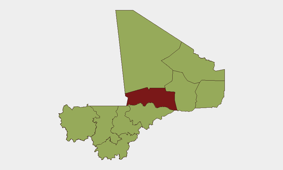
Situation Summary
Mali faces sustained high-threat conditions driven by active conventional and insurgent military operations across the north, particularly around Anefis (Kidal region), where Malian armed forces and Russian Africa Corps elements have conducted major coordinated operations over the past 48 hours. The government's recent military offensive has achieved tactical gains—securing the Gao–Anefis supply corridor and reporting significant casualty and equipment losses among separatist and jihadist groups—but the broader security environment remains volatile, with unpredictable rebel and terrorist activity persisting across northern regions. Concurrent diplomatic tensions (expulsions of French personnel, arrests, and public disapprovals involving regional and international actors) suggest political fragmentation and potential constraints on Mali's security partnership landscape.
Key Developments
- Anefis, Kidal region (9–10 July 2026): Tuareg-led separatist group (Azawad Liberation Front, FLA) withdrew from Anefis after clashes with Malian forces and Africa Corps, citing "strategic reasons" and civilian-casualty concerns; Malian army convoys from Gao successfully reinforced the town and retook control.
- Northern Mali air-ground campaign (9–10 July 2026): Malian military conducted 15 airstrikes across Anefis, Gao, Kidal, and Sévaré, reportedly destroying 12 combat vehicles and killing approximately 100 insurgents in a 24-hour span; officials claim over 1,000 militants "neutralized" and more than 300 motorcycles destroyed across the broader operation.
- Gao–Anefis supply route (9–10 July 2026): Malian forces announced securing the corridor to Anefis, reversing recent rebel interdiction attempts and restoring a critical northern supply line.
- Strategic positions cleared (10 July 2026): Army announced clearance of armed-group strongholds in Anefis following joint operations with Africa Corps.
- Mali–France expulsion (12 July 2026): Mali expelled French military and diplomatic personnel, reflecting ongoing geopolitical friction and potential impact on security-force cooperation.
- Arrest of Iraqi national (11 July 2026): Mali detained an Iraqi national; context and implications remain unclear from available reporting but signal continued foreign-actor involvement or investigation.
- Regional disapprovals (11–13 July 2026): Mali issued public disapprovals toward Algeria and Israel; Bamako rejected an unspecified proposal on 11 July, indicating diplomatic instability.
Highest-Risk Areas
Timbuktu (82.1) stands as Mali's single highest-risk region, reflecting sustained jihadist and separatist presence, porous borders, and limited state control. The second tier—Bamako (55.6) and a cluster of northern/central regions (Ménaka, Kayes, Taoudénit, Kidal, Gao, Koulikoro, Ségou, Sikasso, Mopti, each 52.1)—indicates broad geographic exposure. Risk concentrates in the north and center due to active insurgent bases, ethnic and sectarian friction, and weak governance; Bamako's elevation reflects urban crime, political instability, and as the capital, exposure to state-level shocks (coups, mass unrest). Recent military gains around Anefis have not materially reduced underlying threat density in neighboring regions.
How GeoBit Would Assist
Security teams monitoring Mali would employ AOI Monitoring & Early Warning to track Anefis, Gao, Timbuktu, and other high-risk zones for renewed militant concentration or supply-line disruption. Battle Mapping and Force Structure analysis would enable near-real-time assessment of Malian army and Africa Corps positioning, readiness, and casualty sustainability. Routing & Network Analysis would support identification of safe alternative supply and personnel-movement corridors, accounting for current roadblocks and rebel activity. Intel Sweep and multi-language OSINT fusion (X, Telegram, regional media) would provide early signals of diplomatic shifts, faction movements, or planned operations that corporate presence might exploit or evade.
7-Day Outlook
Malian military momentum in the Anefis corridor is likely to persist over the next week, though rebel groups may reposition to less-exposed terrain. Diplomatic friction (France expulsion, regional disapprovals) may constrain external air support or intelligence-sharing, complicating the army's sustainability. Overall threat posture will remain elevated and volatile; no significant de-escalation is expected in the near term.
Highest-Risk Areas — Ranked
| # | State / Region | Risk |
|---|---|---|
| 1 | Timbuktu | 82.1 |
| 2 | Bamako | 55.6 |
| 3 | Ménaka | 52.1 |
| 4 | Kayes | 52.1 |
| 5 | Taoudénit Region | 52.1 |
| 6 | Kidal | 52.1 |
| 7 | Gao | 52.1 |
| 8 | Koulikoro | 52.1 |
| 9 | Ségou Region | 52.1 |
| 10 | Sikasso Region | 52.1 |
| 11 | Mopti | 52.1 |
Sources
Previous Daily Briefs
A new Mali brief is written every day — each with its own risk map and downloadable CSV. Here's the last week; use the calendar to go further back.
📅 Browse every day by calendar →
Highlighted days have a brief. Tap a day for that day's map & analysis, or “csv” for that day's dataset ($5).
Atlas — our AI intelligence desk — emails them this snapshot personally. Nothing else, no list.