Situation Summary
Myanmar remains in active civil war with a composite threat score placing it #10 globally, driven by sustained armed clashes between the military junta and multiple armed resistance groups across at least 6 tracked major events in the past 48 hours. Death tolls have exceeded 100,000, with millions displaced and critical infrastructure degraded nationwide. The security picture shows no sign of de-escalation; instead, reporting from 9–10 July confirms intensifying operations and fresh civilian casualties across multiple regions.
Key Developments
- Maungdaw Township, Rakhine State (9 July) – Myanmar military resumed airstrikes against Arakan Army positions near the Bangladesh border; videos documented smoke and fires visible from Bangladeshi territory, creating cross-border spillover concern and highlighting lack of formal coordination with neighboring authorities.
- Teknaf frontier area, Cox's Bazar, Bangladesh (9 July) – Border communities reported visible fires and smoke from inside Myanmar and heightened anxiety over civilian risk, with local observers noting Myanmar authorities did not formally notify Bangladesh of military operations.
- Myit Chay area (9 July) – Fresh displacement and civilian casualties from recent fighting documented; local families conducting prayers for newly killed relatives underscore ongoing harm to non-combatants in active conflict zones.
- Bago Region (through 9 July) – Recent hard-hit designation confirmed by ACLED data; elevated fatality counts from military operations and crackdowns indicate sustained operational tempo and civilian exposure across the region.
- Central Myanmar, multiple townships (9 July) – ACLED reporting confirms continuing nationwide armed clashes and attacks, with no geographic concentration—fighting spans urban and rural zones and suggests widespread rather than localized security risk.
- Nationwide, 9–10 July – Analysis released 10 July notes armed resistance and junta operations remain intense across multiple states; millions displaced, infrastructure degraded, and services increasingly unavailable, reinforcing very high travel and operational risk across much of the country in the 24–48 hour window.
- Judicial and diplomatic signals (10 July) – Multiple "Reduce Relations" and "Coerce" events recorded on 10 July involving judges, criminals, and Myanmar state actors, alongside a China–Myanmar coercion event, suggest concurrent pressure on governance and international relations that may constrain humanitarian access or predictability.
Highest-Risk Areas
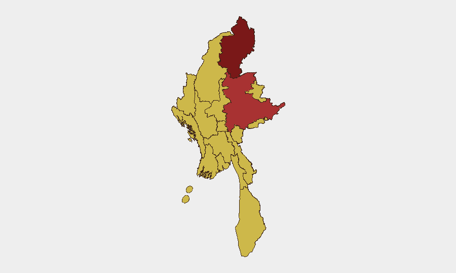
Kachin State leads all sub-national zones at risk score 100, followed by Shan State (78.6), with Tanintharyi, Chin, Sagaing, and Northern Wa State all at 70. The remaining major centers—Mandalay, Yangon, Naypyitaw, and key regions—are all scored at 70, reflecting nationwide conflict saturation rather than isolated hotspots. Kachin and Shan State drive highest risk due to sustained Arakan Army and other armed-group operations; however, the uniform elevation of secondary-tier zones indicates that no major population or administrative center can be considered safe, and risk of armed clashes, displacement, or military operations exists across all regions.
How GeoBit Would Assist
Security teams should deploy AOI Monitoring & Early Warning on Kachin State, Shan, and border regions to receive real-time alerts on renewed airstrikes or clashes before they affect staff or supply chains. Battle Mapping and Conflict Intelligence tools provide current force-position and operational-tempo tracking to inform travel-avoidance and duty-of-care decisions. Routing & Network Analysis should be used to plan alternative routes and safe corridors in real time as front lines shift, and OSINT fusion (X/Twitter, Telegram, YouTube, and local-language sources) enables rapid corroboration of unconfirmed incidents before they escalate.
7-Day Outlook
Airstrikes, armed clashes, and military operations are expected to continue at current intensity across at least Kachin, Shan, Rakhine, and Bago regions. Cross-border spillover and humanitarian access constraints are likely to worsen. No political or ceasefire signals have emerged to suggest near-term de-escalation; sustained high risk should be assumed through mid-July.
Highest-Risk Areas — Ranked
| # | State / Region | Risk |
|---|---|---|
| 1 | Kachin State | 100 |
| 2 | Shan State | 78.6 |
| 3 | Tanintharyi Region | 70 |
| 4 | Chin | 70 |
| 5 | Sagaing Region | 70 |
| 6 | Wa State (Northern Region) | 70 |
| 7 | Magway | 70 |
| 8 | Mandalay | 70 |
| 9 | Rakhine | 70 |
| 10 | Ayeyarwady | 70 |
| 11 | Yangon | 70 |
| 12 | Naypyitaw Union Territory | 70 |
Sources
Previous Daily Briefs
A new Myanmar brief is written every day — each with its own risk map and downloadable CSV. Here's the last week; use the calendar to go further back.
📅 Browse every day by calendar →
Highlighted days have a brief. Tap a day for that day's map & analysis, or “csv” for that day's dataset ($5).
Atlas — our AI intelligence desk — emails them this snapshot personally. Nothing else, no list.