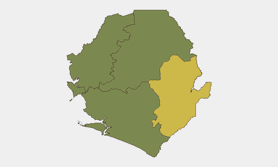
Situation Summary
Sierra Leone remains a low-threat environment globally (rank #124, composite score 9) with no tracked security events recorded in the national aggregate. However, sub-national risk concentration in the Eastern Province (score 68) and Western Area (score 35) reflects localised infrastructure vulnerabilities, cross-border criminal activity, and recent political tension in the capital. The country's security posture is stable but fragmented by geography and institutional capacity constraints.
Key Developments
- Freetown, House of Parliament — 2026-08-13: Security protocols were elevated after an alleged intruder was intercepted attempting to enter the chamber with an unidentified object during a constitutional amendment debate. Sergeants-at-Arms deployed at access points; entry restricted to selected party representatives and diplomats.
- Freetown, Parliament — 2026-08-13: APC lawmakers walked out of the constitutional amendment vote, escalating political friction within the legislature and signalling potential contestation over procedural governance.
- Calaba Town, Western Area — 2026-08-09 (context): A residential building collapsed during heavy rainfall; incident linked to 5 August flooding and chronic drainage infrastructure deficits. While not a security event, such structural failures create humanitarian and access risks in affected zones.
- Mamamah, Eastern Province — 2026-08-09 (context): Police arrested a suspected drug dealer following community intelligence. Reflects baseline law-enforcement activity and low-level narcotics pressure in the region.
- Cross-border law-enforcement — 2026-08-05 (context): Sierra Leone Police Eastern Region transferred a murder suspect to Liberian authorities, demonstrating functional cross-border cooperation but also indicating transnational crime flow.
Highest-Risk Areas
The Eastern Province dominates the sub-national risk landscape (score 68) due to proximity to Liberia, weaker state infrastructure, and ongoing cross-border criminal networks. The Western Area (Freetown and environs, score 35) presents secondary risk driven by urban density, parliamentary/political activity, and infrastructure vulnerabilities exposed by seasonal flooding. Northern, North West, and Southern provinces register zero tracked risk, suggesting either lower incident density or reduced reporting capacity. Organisations with staff or assets in the Eastern Province should prioritise cross-border intelligence and community-policing liaison; Western Area operations should monitor parliamentary stability and seasonal infrastructure hazards.
How GeoBit Would Assist
Area-of-Interest Monitoring & Early Warning on the Eastern Province and Freetown would provide persistent alerting on criminal networks, border movement, and political/institutional developments. OSINT Fusion & Corroboration (X, Telegram, local media, radio SIGINT) enables real-time tracking of political tension, protest activity, and supply-chain disruptions without reliance on official reporting. Routing & Network Analysis supports duty-of-care teams in identifying alternative movement corridors and safe transit windows if parliamentary unrest or flooding escalates, particularly for Western Area and cross-border travel.
7-Day Outlook
Parliamentary political friction is likely to persist through the constitutional amendment process, with sporadic walkouts or procedural disputes. Seasonal rainfall through August will continue to stress drainage infrastructure in urban centres, particularly Freetown and Calaba Town, increasing localised displacement and humanitarian needs. Eastern Province cross-border activity is expected to remain at baseline levels; no escalation in organised crime or armed activity is anticipated unless broader Liberian instability spillover occurs.
Highest-Risk Areas — Ranked
| # | State / Region | Risk |
|---|---|---|
| 1 | Eastern Province | 68 |
| 2 | Western Area | 35 |
| 3 | North West Province, Sierra Leone | 0 |
| 4 | Northern Province, Sierra Leone | 0 |
| 5 | Southern Province, Sierra Leone | 0 |
Sources
- sierraloaded.sl
- sierraleonemonitor.com
- voiceofsalonenewspaper.com
- sierraleonemonitor.com
- thesierraleonetelegraph.com
- freetravelriskmap.sicurogroup.com
- sierraloaded.sl
- afro.who.int
- english.news.cn
- enca.com
- c4dmedianews.com
- sierraloaded.sl
- rfi.fr
- dailymotion.com
- news.un.org
- sierraleonemonitor.com
- thesierraleonetelegraph.com
- frontpageafricaonline.com
Previous Daily Briefs
A new Sierra Leone brief is written every day — each with its own risk map and downloadable CSV. Here's the last week; use the calendar to go further back.
📅 Browse every day by calendar →
Highlighted days have a brief. Tap a day for that day's map & analysis, or “csv” for that day's dataset ($5).
Atlas — our AI intelligence desk — emails them this snapshot personally. Nothing else, no list.