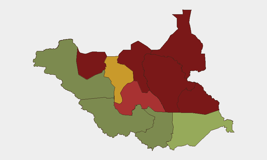
Situation Summary
South Sudan remains in a state of chronic armed conflict with no significant de-escalation in sight. The security environment is characterized by ongoing inter-communal violence, armed-group clashes, cattle raiding, and abductions across multiple states, particularly in the oil-producing north and pastoral regions. As of 12 August 2026, no major discrete incident has been independently verified in the last 24–48 hours, though baseline threat levels remain elevated across the highest-risk states.
Key Developments
- No independently verified new incident in the last 24–48 hours. Active monitoring and multi-language OSINT feeds have not corroborated a discrete security event between 11–12 August 2026. Risk teams should note this represents a reporting gap, not a security improvement.
- 2026-08-10 (Warrap State, Tonj North County). Two near-simultaneous armed attacks—one in Ariec cattle camp (Tonj North), one in Pan-Ariik/Akok village—killed over 60 civilians and injured approximately 50. Armed youth from Unity State were reported to have coordinated the assault, which included livestock looting and displacement. This incident sits outside the 24–48-hour window but underscores active cross-state armed-group mobility and lethality.
- Jonglei / Upper Nile / Unity states (2026-08-08 to 2026-08-10, background context). UNMISS reported intensified clashes between government (SSPDF) and opposition (SPLA-IO) armed groups; peacekeepers increased patrols in response. While these activities predate the current 24–48-hour window, they indicate sustained military tension in the eastern and northern regions.
Highest-Risk Areas
Unity, Jonglei, and Upper Nile states dominate the threat landscape, with composite risk scores of 95, 93, and 88 respectively. All three are experiencing active armed-group confrontation, inter-communal violence, and fluid militia operations; Unity and Jonglei are further destabilized by cross-border cattle-raiding networks and youth mobilization. Greater Pibor Administrative Area (risk 87) and Northern Bahr el Ghazal (risk 82) follow, driven by pastoralist conflict and resource competition. By contrast, Central Equatoria (which includes Juba) and Western Bahr el Ghazal carry substantially lower risk (35 and 28), reflecting greater government presence and lower incidence of armed clashes, though baseline criminality and displacement remain concerns.
How GeoBit Would Assist
Security teams operating in or supporting personnel in South Sudan should deploy persistent AOI monitoring and early-warning alerting on high-risk states (especially Unity, Jonglei, Upper Nile) to capture emerging clashes, roadblocks, and displacement events in near-real time. Multi-language OSINT fusion (X/Twitter, local outlets, radio SIGINT, YouTube/Telegram intelligence) combined with conflict battle mapping and force-structure tracking enables situational awareness of armed-group positions, SSPDF movements, and inter-communal flashpoints. GIS and spatial analysis integrated with alternative route planning can support duty-of-care assessments and contingency evacuation routing away from active-threat zones.
7-Day Outlook
No major ceasefire or political breakthrough is anticipated in the near term. Cross-state armed-youth movements and cattle-raiding cycles are likely to persist, with particular volatility in Unity and Warrap counties. Risk teams should assume baseline threat conditions will remain elevated and prepare contingency protocols for rapid escalation or localized displacement events.
Highest-Risk Areas — Ranked
| # | State / Region | Risk |
|---|---|---|
| 1 | Unity | 95 |
| 2 | Jonglei | 93 |
| 3 | Upper Nile | 88 |
| 4 | Greater Pibor Administrative Area | 87 |
| 5 | Northern Bahr el Ghazal | 82 |
| 6 | Lakes | 78 |
| 7 | Warrap | 72 |
| 8 | Ruweng Administrative Area | 68 |
| 9 | Eastern Equatoria | 52 |
| 10 | Western Equatoria | 38 |
| 11 | Central Equatoria | 35 |
| 12 | Western Bahr el Ghazal State | 28 |
Sources
Previous Daily Briefs
A new South Sudan brief is written every day — each with its own risk map and downloadable CSV. Here's the last week; use the calendar to go further back.
- August 11, 2026
- August 10, 2026
- August 9, 2026
- August 7, 2026
- August 6, 2026
- August 4, 2026
- August 2, 2026
📅 Browse every day by calendar →
Highlighted days have a brief. Tap a day for that day's map & analysis, or “csv” for that day's dataset ($5).
Atlas — our AI intelligence desk — emails them this snapshot personally. Nothing else, no list.