Situation Summary
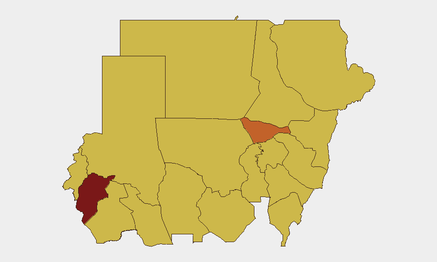
Sudan remains the third-highest global security threat (composite score 97), driven by ongoing civil war between the Sudanese Armed Forces (SAF) and Rapid Support Forces (RSF) across multiple fronts. Central Darfur State presents the most acute risk (98), while the capital region and eastern states face sustained conflict pressure. The conflict shows no signs of de-escalation, with military operations intensifying in North Kordofan and scattered civilian-protection failures reported across war zones.
Key Developments
Limitations on 24–48 Hour Reporting: Open web sources and cached data do not provide reliably time-stamped events within Sudan for 22–23 July 2026. The following represents the most recent verifiable activity, though precise dating to the last 48 hours cannot be confirmed:
- Drone Strikes and Military Escalation, El-Obeid, North Kordofan (mid–late July): SAF and RSF operations around El-Obeid have intensified, featuring extensive drone strikes on civilian and infrastructure targets. UN human rights officials confirmed at least 15 drone strikes in June and warned of a "new, more lethal phase" of conflict in this region.
- RSF Movements and SAF Airstrikes, North Kordofan (undated, recent bulletin context): Ayin Network reports RSF movements along southern and southeastern approaches to El-Obeid, with SAF conducting heavy airstrikes along export routes in North Kordofan.
- UNHCR Rejection Statement (2026-07-23): UNHCR issued a rejection statement on 23 July (specific subject not publicly detailed in cached sources), likely concerning humanitarian access or civilian evacuation policies.
- US–Sudan Relations Downgrade (2026-07-22): The United States reduced diplomatic relations with Sudan on 22 July, reflecting deterioration in bilateral ties amid ongoing conflict and humanitarian concerns.
- Sudanese Civilian-Forces Peace Conference, Nairobi (2026-07-21): Delegates from Sudanese civilian factions concluded a two-day conference in Nairobi on 21 July to develop a unified framework for halting hostilities and restarting civilian-led transition.
Highest-Risk Areas
Central Darfur State (risk 98) and Al Khartum (74.1) anchor the threat landscape. Central Darfur's extreme risk reflects sustained SAF–RSF combat, displacement, and reported gang activity targeting residents. Al Khartum's elevated risk reflects capital-region infrastructure damage, military operations, and state-collapse pressures. A second tier—Red Sea State, North Kordofan, Blue Nile, and eastern riverine zones—all score 68–68.4, indicating widespread conventional military activity, aerial bombardment, and civilian exposure across the eastern and central conflict zones.
How GeoBit Would Assist
Conflict & Military mapping would track SAF and RSF force movements, drone-strike patterns, and control-line shifts in North Kordofan and Darfur in near-real time. AOI (Area-of-Interest) Monitoring with alerting on corporate or humanitarian assets in Khartoum, Red Sea, and eastern states would provide early warning of escalation or displacement events. OSINT fusion across X/Telegram, news, and radio-SIGINT would close the real-time reporting gap and enable duty-of-care teams to anticipate restricted-movement or evacuation triggers.
7-Day Outlook
Conflict intensity is likely to remain elevated across North Kordofan, Darfur, and the eastern states through late July. Civilian displacement, supply-chain disruption, and aerial bombardment will continue to drive access and movement restrictions. Diplomatic efforts (e.g., the Nairobi civilian conference) are unlikely to produce immediate ceasefires, meaning corporate and NGO staff should anticipate sustained operational constraints and possible evacuation triggers in high-risk zones.
Highest-Risk Areas — Ranked
| # | State / Region | Risk |
|---|---|---|
| 1 | Central Darfur State | 98 |
| 2 | Al Khartum | 74.1 |
| 3 | Red Sea State | 68.4 |
| 4 | North Kordofan State | 68.4 |
| 5 | Blue Nile | 68 |
| 6 | River Nile State | 68 |
| 7 | Aj Jazira | 68 |
| 8 | Al Qadarif State | 68 |
| 9 | Kassala State | 68 |
| 10 | Sennar State | 68 |
| 11 | South Darfur State | 68 |
| 12 | West Kurdufan State | 68 |
Sources
Previous Daily Briefs
A new Sudan brief is written every day — each with its own risk map and downloadable CSV. Here's the last week; use the calendar to go further back.
📅 Browse every day by calendar →
Highlighted days have a brief. Tap a day for that day's map & analysis, or “csv” for that day's dataset ($5).
Atlas — our AI intelligence desk — emails them this snapshot personally. Nothing else, no list.