Situation Summary
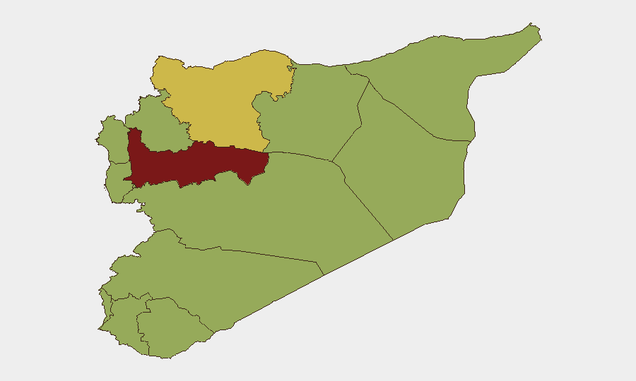
Syria remains the 20th highest-threat country globally (composite score 80), with civil conflict and terrorism as primary drivers. The recent arrest of an ISIS-linked cell linked to the July 7 bombing near Damascus during French President Macron's visit reflects ongoing counter-terrorism operations, yet the incident itself—killing 1 and wounding 36—demonstrates the persistent terrorist threat to high-profile targets and civilian infrastructure. Security operations have expanded across Damascus with heightened checkpoints and surveillance, signaling authorities' recognition of active terrorist networks. The threat environment remains volatile, with Hama Governorate (risk 86) and Damascus (risk 60.6) posing the highest sub-national risks.
Key Developments
- Damascus, July 13: Interior Minister Anas Khattab announced the arrest of an ISIS-affiliated cell responsible for the July 7 twin IED attack near the Four Seasons Hotel, with all identified members now in custody. Syrian state media and Al Jazeera confirmed the cell's direct involvement in the bombings that occurred during Macron's diplomatic visit.
- Damascus, July 13: Authorities launched sweeping security operations across the capital, including expanded checkpoints, armed patrols, and intensified surveillance around government buildings, judicial institutions, and foreign diplomatic sites in response to the captured cell.
- Damascus, July 13: Investigators are actively tracing vehicle ownership from the July 7 car bomb and screening urban infrastructure for additional IEDs, with special security units conducting localized surveillance and secondary-device searches.
- Damascus, July 13: Updated casualty figures from the July 7 bombings now stand at 1 killed and 36 wounded, revised upward from initial reports of 18 injured. Both Le Monde and Al Jazeera corroborated the revised toll.
- Deir Ezzor Governorate, July 13: Death toll from a Euphrates ferry capsizing near Deir Ezzor city rose to four persons, with search operations ongoing. The incident underscores infrastructure and travel-safety risks on river transport routes in eastern Syria.
- Multi-location, July 12–14: Recent event signals include European public statements on Syria, French disapproval directed at Damascus, Italian public statements, and rejection statements from a mayor—indicating elevated diplomatic and internal governance tensions accompanying the security operations.
Highest-Risk Areas
Hama Governorate (86) stands as the highest-risk sub-national area, reflecting sustained conflict intensity. Damascus Governorate (60.6) and Aleppo (60.2) follow, driven by active terrorist cells, counter-terrorism sweeps, and diplomatic vulnerabilities—as evidenced by the July 7 bombings targeting a foreign leader's visit. The eastern governorates (Al-Hasaka, Ar-Raqqa, Deir Ezzor) and southern regions (Dar'a, Al-Quneitra, UNDOF) all register at risk 56, indicating residual conflict and ISIS remnant activity. Lattakia, Tartus, Homs, and Idleb share the same risk tier, reflecting fragmented control and lingering militant presence across the country's geography.
How GeoBit Would Assist
Security teams should employ Intel Sweep and X/Twitter & Telegram OSINT to track emerging ISIS cell activity and official Syrian statements in real time. AOI Monitoring & Early Warning applied to Damascus, Hama, and key diplomatic compounds would provide persistent alerting on security incidents and checkpoint expansion. Conflict & Military battle mapping and Network & Actor Analysis would map ISIS affiliate nodes and counter-terrorism operations, while Routing & Network Analysis supports alternative journey planning around expanded security cordons and checkpoints.
7-Day Outlook
Counter-terrorism operations are expected to intensify across Damascus over the next week as authorities consolidate the cell arrest and complete secondary-device sweeps. Diplomatic and internal governance tensions, signaled by recent public statements, may escalate in parallel. Risk to foreign nationals and high-profile targets remains elevated, particularly around government and diplomatic facilities.
Highest-Risk Areas — Ranked
| # | State / Region | Risk |
|---|---|---|
| 1 | Hama Governorate | 86 |
| 2 | Damascus Governorate | 60.6 |
| 3 | Aleppo Governorate | 60.2 |
| 4 | Al-Hasaka Governorate | 56.2 |
| 5 | Lattakia Governorate | 56 |
| 6 | Tartus Governorate | 56 |
| 7 | UNDOF | 56 |
| 8 | Al-Quneitra Governorate | 56 |
| 9 | Dar'a Governorate | 56 |
| 10 | Idleb Governorate | 56 |
| 11 | Ar-Raqqa Governorate | 56 |
| 12 | Homs Governorate | 56 |
Sources
Previous Daily Briefs
A new Syria brief is written every day — each with its own risk map and downloadable CSV. Here's the last week; use the calendar to go further back.
📅 Browse every day by calendar →
Highlighted days have a brief. Tap a day for that day's map & analysis, or “csv” for that day's dataset ($5).
Atlas — our AI intelligence desk — emails them this snapshot personally. Nothing else, no list.