Situation Summary
Angola's national security environment remains stable, with no verified armed conflict, civil unrest, mass crime, or politically motivated violence reported in the last 24–48 hours. The capital and most populated regions show baseline stability; however, resource-extraction and smuggling dynamics in the northeastern and eastern border provinces (Cabinda, Lunda Norte, Lunda Sul) sustain elevated structural risk. Current trajectory is one of operational normalcy with no immediate indicators of escalation.
Key Developments
- Angola-wide, August 3–4, 2026 – No corroborated armed clashes, terrorist attacks, protests, or nationally significant crime incidents affecting expatriate populations or corporate operations reported in the last 24–48 hours across all provinces.
- Luanda Province (including Luanda city), August 3–4, 2026 – Capital region shows baseline stability; no new incidents of mass crime, civil unrest, or politically motivated violence affecting foreign travelers or strategic infrastructure in this period.
- Northern and eastern border regions, August 3–4, 2026 – While Cabinda, Lunda Norte, and Lunda Sul remain structurally higher-risk zones due to resource extraction and cross-border smuggling, no newly reported armed clashes, border security crises, or militia activity confirmed in the last 24–48 hours.
- Telecommunications sector, August 3–4, 2026 – Following the widely reported Unitel nationwide cyberattack of July 28–30, 2026, no new cyber incidents or acute disruption to national telecom infrastructure reported; current service conditions are routine rather than crisis-level.
- Angola-wide, August 3–4, 2026 – Multi-source monitoring (traditional media, social platforms, specialist feeds) shows no verified calls for protests, strikes, or organized civil unrest; no evidence of political instability events (coup rumors, mass demonstrations) gaining traction.
- Infrastructure services, August 3–4, 2026 – No major failures reported in national power grid, airports, or ports; only routine, localized service issues below national significance; no travel-disrupting outages confirmed.
Highest-Risk Areas
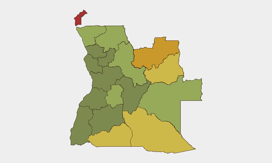
Cabinda Province (risk 78) and Lunda Norte Province (risk 72) are the primary drivers of Angola's elevated sub-national risk profile, followed by Lunda Sul (68) and Cuando Cubango (64). These zones face sustained pressure from resource-extraction competition, transnational smuggling networks, and historical armed-group activity. The northeastern cluster (Cabinda through Moxico) accounts for the majority of country-level risk; by contrast, central and southern provinces (Bié, Huíla) present substantially lower threat profiles. Risk in these border and resource zones remains structural rather than acute—no current crisis indicators—but they warrant continuous monitoring for expatriate movements and supply-chain operations.
How GeoBit Would Assist
Corporate security teams operating in Angola should employ AOI (Area-of-Interest) Monitoring & Early Warning on Cabinda, Lunda Norte, and eastern border crossings to detect emerging armed activity or militia mobilization in real time. Network & Actor Analysis combined with OSINT fusion (X/Twitter, Telegram, local media) would provide early signals of political instability, labor strikes, or organized protest activity before they escalate. Routing & Network Analysis enables alternative journey planning for personnel movements in high-risk provinces, while satellite and imagery analysis can corroborate infrastructure status and confirm stability in critical operational zones.
7-Day Outlook
Angola's security environment is expected to remain stable over the next seven days absent major political, economic, or cross-border triggering events. Structural risk in resource-rich northeastern provinces will persist; however, no indicators suggest imminent armed conflict or civil unrest escalation. Routine monitoring of telecom resilience post-Unitel outage and standard tracking of border-region activity remain appropriate.
Highest-Risk Areas — Ranked
| # | State / Region | Risk |
|---|---|---|
| 1 | Cabinda Province | 78 |
| 2 | Lunda Norte Province | 72 |
| 3 | Lunda Sul Province | 68 |
| 4 | Cuando Cubango Province | 64 |
| 5 | Cunene Province | 62 |
| 6 | Moxico Province | 58 |
| 7 | Zaire Province | 54 |
| 8 | Huambo Province | 50 |
| 9 | Uíge Province | 48 |
| 10 | Malanje Province | 42 |
| 11 | Bié Province | 35 |
| 12 | Huíla Province | 32 |
Sources
Previous Daily Briefs
A new Angola brief is written every day — each with its own risk map and downloadable CSV. Here's the last week; use the calendar to go further back.
📅 Browse every day by calendar →
Highlighted days have a brief. Tap a day for that day's map & analysis, or “csv” for that day's dataset ($5).
Atlas — our AI intelligence desk — emails them this snapshot personally. Nothing else, no list.