Situation Summary
Central African Republic remains in a state of fragile instability, ranked #23 globally in composite threat severity. Armed group activity, particularly in the north and east, continues to challenge government and MINUSCA (UN) control despite recent defensive operations. The government's formation of a defence board in late June and ongoing MINUSCA force reductions create a dual dynamic of heightened alert and potential security gaps as peacekeeping operations transition to mobile postures.
Key Developments
- Am Dafock, Vakaga Prefecture (2026-07-02): Rebel fighters mounted a coordinated attack killing at least 10 civilians and wounding 3 UN peacekeepers before government forces and Russian-backed units retook the town, signalling continued rebel capability in border regions.
- Northern CAR (2026-06-30): A newly formed coalition of political-military groups launched a surprise offensive that prompted President Touadéra to establish a defence board, indicating both tactical surprise and institutional response to rising armed group coordination.
- Mbaïki (2026-07-17): MINUSCA handed over a military base to CAR authorities as part of its planned drawdown, with 48 bases scheduled for handover by end-2026—a critical juncture for assessing security coverage during the transition.
- MINUSCA Footprint Reduction (2026-07-17): The shift from fixed-base to mobile operations is raising concern among analysts about potential security vacuums in peripheral regions, particularly in the north and east where armed group presence remains active.
- Bishop–Italy Diplomatic Signal (2026-07-18): A disapproval statement between religious leadership and Italy suggests possible pressure on external support networks or diplomatic backing for CAR's stability efforts, though clarity on underlying cause remains limited.
Highest-Risk Areas
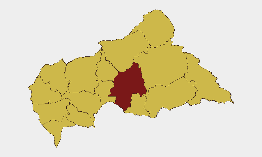
Ouaka prefecture (95.2 composite risk) is the primary driver of national threat severity, followed by ten prefectures clustered at 65.2 risk—a uniform pattern suggesting either systematic underreporting outside Ouaka or a genuinely concentrated threat footprint in the north and east. The concentration in border regions (Vakaga, Haute-Kotto, Haut-Mbomou, Mbomou) and northern interior zones (Ouham, Ouham-Pendé, Bamingui-Bangoran) aligns with known rebel sanctuaries and cross-border infiltration corridors from Sudan and Chad. MINUSCA's planned drawdown will disproportionately affect peripheral prefectures with limited government presence.
How GeoBit Would Assist
Security teams should employ Intel Sweep and OSINT fusion (X/Telegram monitoring, multi-language feeds, entity extraction) to track armed group communications and coalition movements in real time. AOI Monitoring & Early Warning paired with GIS & spatial analysis enables persistent surveillance of high-risk prefectures—particularly Ouaka and border zones—with automated alerting on suspicious activity near corporate or personnel locations. Conflict & Military tracking (force structure, battle mapping) supports duty-of-care assessments as MINUSCA reduces footprint and government control zones shift.
7-Day Outlook
Armed group pressure is expected to persist or intensify over the next week, particularly in northern and eastern prefectures as the dry season favours mobile operations. The MINUSCA transition will likely create tactical openings for rebel activity; security incidents may spike around handover sites. Corporate and NGO personnel in Ouaka, Vakaga, and border-adjacent prefectures should anticipate elevated risk and consider heightened movement restrictions pending clearer government stabilisation signalling.
Highest-Risk Areas — Ranked
| # | State / Region | Risk |
|---|---|---|
| 1 | Ouaka | 95.2 |
| 2 | Bamingui-Bangoran | 65.2 |
| 3 | Vakaga | 65.2 |
| 4 | Haute-Kotto | 65.2 |
| 5 | Haut-Mbomou | 65.2 |
| 6 | Mbomou | 65.2 |
| 7 | Nana-Mambéré | 65.2 |
| 8 | Ouham-Pendé | 65.2 |
| 9 | Mambéré-Kadéï | 65.2 |
| 10 | Sangha-Mbaéré | 65.2 |
| 11 | Ouham | 65.2 |
| 12 | Nana-Grébizi | 65.2 |
Sources
Previous Daily Briefs
A new Central African Republic brief is written every day — each with its own risk map and downloadable CSV. Here's the last week; use the calendar to go further back.
📅 Browse every day by calendar →
Highlighted days have a brief. Tap a day for that day's map & analysis, or “csv” for that day's dataset ($5).
Atlas — our AI intelligence desk — emails them this snapshot personally. Nothing else, no list.