Situation Summary
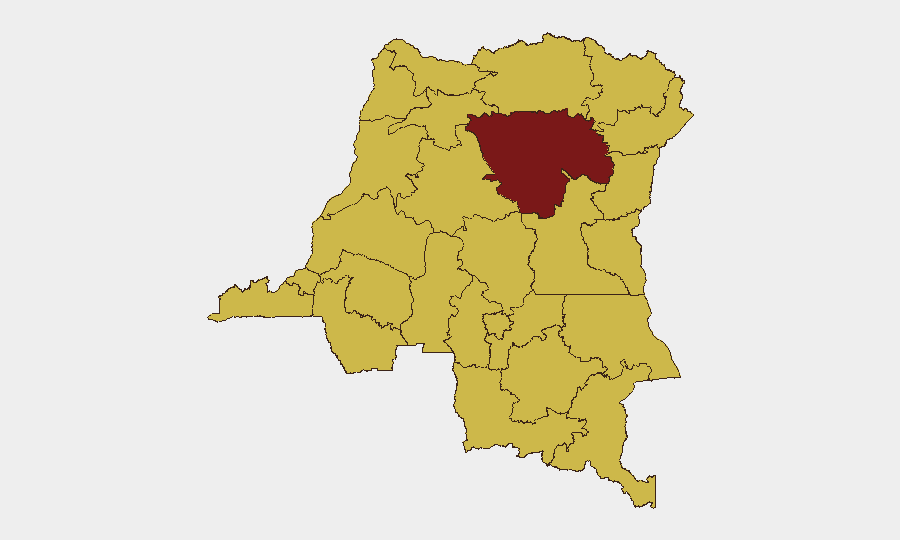
DR Congo remains at elevated composite threat level (#14 globally, score 96) driven primarily by active armed conflict in eastern provinces and ongoing political volatility in the capital. Tshopo province dominates the sub-national risk ranking (97.3), reflecting sustained heavy fighting, drone and artillery use, and attacks on civilian infrastructure including health facilities. The security environment is characterized by concurrent threats: kinetic conflict in the east, protest mobilization and potential civil unrest in Kinshasa, and a rapidly expanding Ebola outbreak complicating both humanitarian operations and security force deployment.
Key Developments
No clearly verifiable, discretely time-stamped new security incidents in DR Congo have been independently confirmed across multiple open sources for the 24–48 hour period of 13–15 July 2026. Available reporting frames the threat environment as ongoing rather than event-specific. For operational planning, the following conditions remain active as of 11–12 July and show no indication of de-escalation:
- Eastern conflict zones (Tshopo, North Kivu, South Kivu, Ituri): Continued heavy fighting between FARDC and M23-aligned forces, with documented use of armed drones, artillery, and explosive weapons in civilian areas; no new discrete incidents independently dated to 13–15 July in available sources.
- Kinshasa (Gombe district, Palais du Peuple): Opposition coalition C64 sustains protest mobilization against constitutional reform; authorities maintain warnings of short-notice volatility, especially on routes to N'Djili airport after dark. Last clearly dated major crackdown reported 12 June 2026.
- Ebola outbreak (multi-provincial, Ituri, North Kivu): Bundibugyo species outbreak reached ~2,000 confirmed cases and >700 deaths as of 11 July; expansion into new health zones (e.g., Boga, Ituri) and documented attacks on treatment centers (Butembo, 6–7 July) create compounding health and security risks.
Highest-Risk Areas
Tshopo province (97.3) is the single highest-risk sub-national area, driven by the concentration of active military operations, drone strikes, and attacks on civilian infrastructure. The remaining ten highest-risk provinces cluster at 67.3, reflecting a broad band of concurrent threats across eastern and northern zones: Maniema, Sud-Ubangi, Équateur, Nord-Ubangi, Mongala, Lower Uele, Tshuapa, Upper Uele, Ituri, North Kivu, and Lualaba. These areas face overlapping pressures from armed group activity, FARDC operations, humanitarian access disruption, and (in eastern zones) health-security complications from the Ebola outbreak. Kinshasa, while not in the top sub-national list, remains a secondary concentration point for political risk and protest-related violence, particularly around parliament and government districts.
How GeoBit Would Assist
Security teams should deploy AOI Monitoring & Early Warning on Tshopo, North Kivu, and Gombe district to detect real-time incidents and short-notice violence; pair this with Intel Sweep and OSINT fusion (Twitter/Telegram, local radio SIGINT) to corroborate event claims and distinguish noise from actionable threat signals. Battle mapping and satellite imagery analysis provide tactical situational awareness of force movements and infrastructure damage in active conflict zones. Routing & Network Analysis supports duty-of-care by modeling alternative travel corridors around Kinshasa and eastern provinces during periods of heightened protest or kinetic activity.
7-Day Outlook
Absent significant diplomatic intervention or ceasefire announcement, fighting in eastern provinces is expected to remain intense and volatile through late July. Kinshasa protest activity will likely persist as constitutional reform debates continue, creating recurring short-notice risk windows. Ebola case counts and geographic expansion are projected to accelerate, compounding strain on health and security infrastructure across Ituri and North Kivu.
Highest-Risk Areas — Ranked
| # | State / Region | Risk |
|---|---|---|
| 1 | Tshopo | 97.3 |
| 2 | Maniema | 67.3 |
| 3 | Sud-Ubangi | 67.3 |
| 4 | Équateur | 67.3 |
| 5 | Nord-Ubangi | 67.3 |
| 6 | Mongala | 67.3 |
| 7 | Lower Uele | 67.3 |
| 8 | Tshuapa | 67.3 |
| 9 | Upper Uele | 67.3 |
| 10 | Ituri | 67.3 |
| 11 | North Kivu | 67.3 |
| 12 | Lualaba | 67.3 |
Sources
Previous Daily Briefs
A new DR Congo brief is written every day — each with its own risk map and downloadable CSV. Here's the last week; use the calendar to go further back.
📅 Browse every day by calendar →
Highlighted days have a brief. Tap a day for that day's map & analysis, or “csv” for that day's dataset ($5).
Atlas — our AI intelligence desk — emails them this snapshot personally. Nothing else, no list.