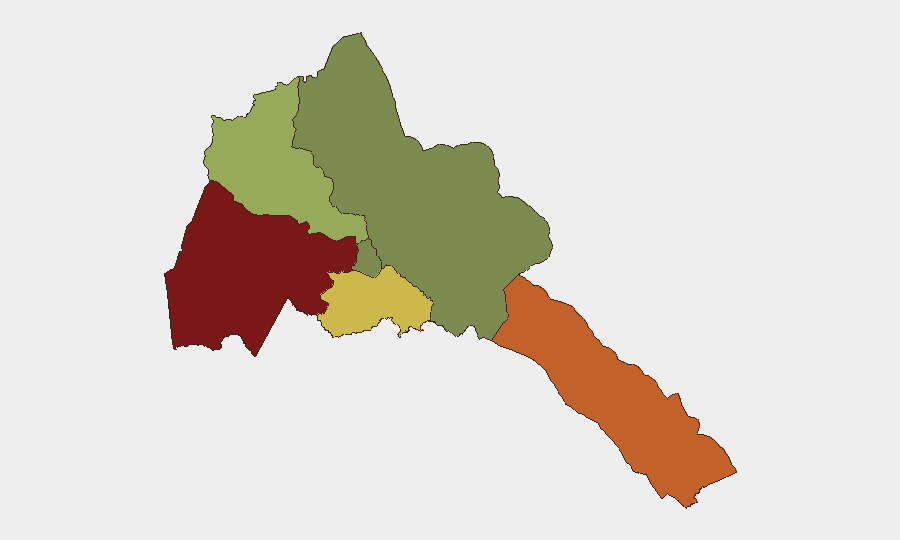
Situation Summary
Eritrea itself remains internally stable with no reported discrete security incidents in the past week, but the country faces mounting regional political and maritime pressures. Ethiopia-Eritrea tensions have escalated sharply following Asmara's formal accusations of Ethiopian destabilization and proxy activity; simultaneously, rapid Houthi advances across the southern Red Sea—including capture of key maritime chokepoints opposite Eritrea's coast—have elevated shipping, energy-corridor, and strategic vulnerability risk. New financial controls (cash-holding caps issued 9 September) signal domestic economic tightening. The threat profile is regional and systemic rather than acute or localized.
Key Developments
- Asmara, 12 September: Eritrea's Ministry of Foreign Affairs issued a formal diplomatic statement accusing Ethiopia of actively destabilizing the Horn of Africa and hosting, training, and financing proxy groups targeting Eritrea—the sharpest escalation in public rhetoric between the two governments in the current reporting window.
- Asmara, 12–14 September: Government-linked officials amplified accusations via social media and state channels of Ethiopian "rabid disinformation" and "belligerence," creating a more adversarial information environment and signalling heightened political tension.
- Asmara, 11 September: Foreign Minister Osman Saleh stated in an interview that there is "no military solution" to the Yemen conflict, indirectly flagging concern about regional Red Sea security near Eritrean maritime approaches.
- Southern Red Sea / Bab el-Mandeb, 10–14 September: Yemeni Houthi forces conducted a rapid offensive capturing Mocha (10 Sep), Perim Island in the Bab el-Mandeb Strait (10–12 Sep), and Greater and Lesser Hanish Islands (14 Sep)—bringing active conflict directly opposite Eritrea's coastline and intensifying maritime security risk.
- Red Sea corridor, 12–14 September: Analysis pieces assessed Houthi control of key maritime chokepoints as creating "gatekeeper leverage" over Red Sea access and heightening strategic pressure on Eritrea, whose capacity and willingness to secure the waterway remain ambiguous and uncoordinated with multilateral partners.
- Asmara, 9 September: The Bank of Eritrea issued Legal Notice No. 134/2026, imposing strict cash-holding limits on individuals (25,000 nakfa maximum for periods exceeding 15 days) and private institutions, with legal penalties for violations—tightening financial controls and introducing operational risk for businesses.
- Eritrea (national), 9 and 14 September: European travel advisories reiterated partial travel warnings, citing "concrete danger to life and limb," advising against non-essential travel, and noting potential escalation to full evacuation calls.
- Horn of Africa regional ports, 14 September: Eritrea publicly accused the United Arab Emirates of "port-based colonialism" via involvement in Berbera (Somaliland) and Bosaso (Puntland), framing foreign port infrastructure as a strategic and political threat.
Highest-Risk Areas
Gash-Barka (score 92) and Southern Red Sea Region (score 75) dominate the risk ranking, reflecting border volatility with Sudan and Ethiopia respectively, combined with exposure to Houthi maritime activity and Eritrea's limited maritime security capacity. Debub Region (68) faces similar pressures. Maekel Region (Asmara, score 18) remains the lowest-risk zone, though political tensions and financial controls announced this week carry economy-wide implications. Risk is primarily a function of regional geopolitics and maritime insecurity rather than internal crime or civil unrest.
How GeoBit Would Assist
Security teams would deploy AOI Monitoring & Early Warning capabilities to track Red Sea maritime activity, cross-border movements, and political signalling from Asmara and Addis Ababa in real time. Multi-language OSINT and sentiment analysis on Eritrean state media, X/Telegram, and regional news feeds would provide early detection of further Ethiopia-Eritrea escalation or domestic policy shifts affecting business operations. Routing & Network Analysis and Maritime tracking would help identify safe corridors and maritime risk zones for personnel and shipments transiting the Red Sea or approaching Eritrean ports.
7-Day Outlook
Ethiopia-Eritrea rhetoric is likely to remain elevated, with risk of further diplomatic incidents or proxy activity. Houthi consolidation of Red Sea territory will continue to constrain shipping and increase maritime insurance and diversion costs. Financial controls and travel advisories may persist, affecting personnel mobility and supply-chain reliability. No imminent internal security collapse is anticipated, but regional instability and economic tightening warrant sustained monitoring.
Highest-Risk Areas — Ranked
| # | State / Region | Risk |
|---|---|---|
| 1 | Gash-Barka | 92 |
| 2 | Southern Red Sea Region | 75 |
| 3 | Debub Region | 68 |
| 4 | Anseba | 55 |
| 5 | Maekel Region | 18 |
| 6 | Northen Red Sea Region | 0 |
Sources
Previous Weekly Briefs
A new Eritrea brief is written every Monday, covering the week — each with its own risk map and downloadable CSV. Use the calendar to go further back.
- September 8, 2026
- September 2, 2026
- August 31, 2026
- August 29, 2026
- August 27, 2026
- August 25, 2026
- August 23, 2026
📅 Browse past briefs by calendar →
Highlighted days have a brief. Tap a day for that day's map & analysis, or “csv” for that day's dataset ($5).
Atlas — our AI intelligence desk — emails them this snapshot personally. Nothing else, no list.