Situation Summary
Iraq faces an acute escalation in drone and conventional military activity, concentrated in the Kurdistan Region and driven by Iranian-linked strikes against U.S. and Kurdish assets. The past 48 hours have witnessed sustained aerial operations involving at least eight intercepted drones over Erbil, strikes on oil infrastructure in Basra, and attacks on Iranian opposition camps in Sulaymaniyah—signals of a broader regional power contest playing out on Iraqi territory. Critical infrastructure and foreign operations are already responding, with at least one U.S. energy firm suspending operations. The trajectory is toward continued high-tempo unconventional and drone-based attacks unless de-escalation measures materialize.
Key Developments
- Erbil drone intercepts (July 22, ~04:19–05:25 local): Eight explosive drones shot down over Erbil city by coalition air defenses; shrapnel from at least one intercepted drone struck a civilian vehicle near the U.S. Consulate perimeter, causing damage but no reported injuries.
- Basra oil terminal drone strike (July 22, past hours): An oil tanker at Al-Basra Oil Terminal struck by a drone that impacted but did not detonate; no fire or injuries reported, but confirms targeting of energy infrastructure.
- Al-Harir airbase and Erbil International Airport activity (July 21–22, 48h window): At least one armed drone intercepted over Al-Harir airbase; a Shahed-136 drone reported impacting near Erbil International Airport, elevating aviation risk.
- Sulaymaniyah opposition camp strikes (July 21–22, ~48h window): Two drones struck an Iranian Kurdish opposition group camp near Sulaymaniyah, consistent with Iranian targeting of anti-Tehran groups in the region.
- U.S. energy firm HKN operational suspension (announced within 48h): HKN announced suspension of all operations in Iraq and the Kurdistan Region due to ongoing conflict and security conditions, signaling private-sector risk reassessment.
- Intensified U.S. military aviation presence (July 21–22): Heavy U.S. aircraft activity reported over the Kurdistan Region near the Iranian border, suggesting heightened defensive and operational posture in response to drone threats.
Highest-Risk Areas
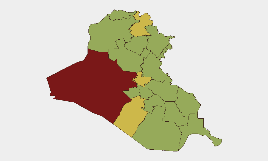
Al-Anbar Governorate remains the composite highest-risk zone (87.1), driven by entrenched insurgency; however, the immediate tactical driver of current threat activity is the Kurdistan Region, particularly Erbil and Sulaymaniyah governorates (both scoring 63.4 and 63.2 respectively), where the past 48 hours have concentrated drone strikes, interceptions, and air-defense operations. Baghdad (67.8) remains a secondary but significant concern for conventional and asymmetric violence. The current escalation pattern reflects Iran-linked drone operations targeting U.S. and allied military assets in the north, overlaid on a baseline of persistent insurgency in western and central Iraq.
How GeoBit Would Assist
Corporate security and duty-of-care teams should employ AOI (Area-of-Interest) Monitoring & Early Warning to track real-time drone activity and militant movements around their sites in Erbil, Baghdad, and Basra. Intel Sweep and OSINT fusion (X, Telegram, local media) provide rapid corroboration of emerging threats and operational tempo changes—critical for daily travel and site-access decisions. Maritime & Aviation tracking and GIS & Spatial Analysis enable teams to map safe transit corridors and avoid airspace conflict zones, while Network & Actor Analysis clarifies attribution and escalation intent behind current Iranian-linked strikes.
7-Day Outlook
Drone and aerial activity is likely to persist or intensify over the next 7 days absent diplomatic intervention. The targeting of oil infrastructure and military bases suggests willingness to accept collateral economic and civilian exposure. Foreign firms and personnel should anticipate further operational suspensions, travel restrictions, and increased demand for alternative supply-chain routing; risk teams should prepare contingency protocols for rapid evacuation or sheltering.
Highest-Risk Areas — Ranked
| # | State / Region | Risk |
|---|---|---|
| 1 | Al-Anbar Governorate | 87.1 |
| 2 | Baghdad Governorate | 67.8 |
| 3 | Erbil Governorate | 63.4 |
| 4 | Al-Najaf Governorate | 63.2 |
| 5 | Babil Governorate | 57.5 |
| 6 | Wasit Governorate | 57.1 |
| 7 | Al-Qadisiyah Governorate | 57.1 |
| 8 | Dhi Qar Governorate | 57.1 |
| 9 | Al-Muthanna Governorate | 57.1 |
| 10 | Maysan Governorate | 57.1 |
| 11 | Al-Basra Governorate | 57.1 |
| 12 | Saladin Governorate | 57.1 |
Sources
Previous Daily Briefs
A new Iraq brief is written every day — each with its own risk map and downloadable CSV. Here's the last week; use the calendar to go further back.
📅 Browse every day by calendar →
Highlighted days have a brief. Tap a day for that day's map & analysis, or “csv” for that day's dataset ($5).
Atlas — our AI intelligence desk — emails them this snapshot personally. Nothing else, no list.