Situation Summary
Lebanon remains at elevated composite threat level (rank #14 globally, score 79) with acute instability concentrated in Beirut and the southern border regions. Over the last 48 hours, multiple security actors—government, military, Israeli forces, and external powers—have issued contradictory statements and taken confrontational actions, signaling a period of high operational tempo and unclear de-escalation trajectory. The Lebanese Army's attempted deployment in southern pilot zones has collided with Israeli military activity, while diplomatic pressure from Washington and Saudi statements add complexity to an already fractured political-security environment. Current trajectory remains volatile with no clear stabilization signal.
Key Developments
- Nabatieh Governorate (Zawtar al-Gharbiya, 26 Jul): Lebanese Army began formal deployment in a U.S.-mediated "pilot zone," marking a shift in southern military posture but met with Israeli obstruction allegations.
- Southern Lebanon (Kfar Tibnit, Nabatieh al-Fawqa, Zawtar al-Gharbiya, 26 Jul): Lebanese Army reported Israeli soldiers opened fire near army positions, disrupting and obstructing the army's southern deployment mission.
- Beirut Governorate (27 Jul): Government and military issued conflicting public statements; government issued threats toward Lebanon and Washington rejected Lebanese positions—signaling internal governance breakdown and international isolation.
- Beirut / Regional (27 Jul): Saudi Arabia issued public statements; Hassan (likely Hezbollah/allied actor) threatened government; both indicate widening factional and cross-border pressure.
- Southern Lebanon (25 Jul): Israeli unconventional violence operations reported; Lebanese Army responded with conventional military force engagement against Israeli forces—escalating from statements to kinetic contact.
- Nabatieh (25–27 Jul): Arrest/detention operations by Lebanese authorities against Syrian nationals; indicates secondary security concerns and possible trafficking or militant-network interdiction.
- Overall Trajectory (20–27 Jul): Despite ceasefire arrangements, continued Israeli shelling and strikes reported in southern villages; Lebanese deployments attempt normalization but face systematic obstruction, suggesting ceasefire is hollow or unenforced.
Highest-Risk Areas
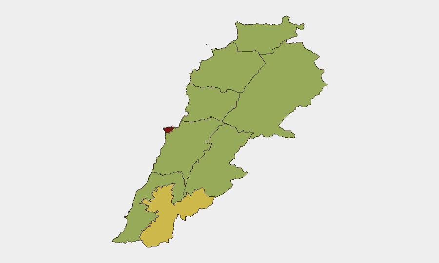
Beirut Governorate (84.9) far exceeds all other regions and remains the epicenter of political, security, and operational risk—home to contested government authority, factional militias, and diplomatic flashpoints. Nabatieh Governorate (68.5), the immediate southern border zone, is the second-highest-risk area due to Israeli military activity, Lebanese Army deployment friction, and the presence of militant groups; it is the geographic locus of current kinetic escalation. All remaining governorates (54.9) cluster at moderate-high risk, indicating that while Beirut and the south dominate, nationwide instability is diffuse and no region offers a genuine security safe haven. The risk concentration in Beirut and Nabatieh reflects both government fragility and unresolved armed-group presence.
How GeoBit Would Assist
Organizations with personnel or assets in Lebanon should leverage AOI Monitoring & Early Warning for persistent watch on Beirut Governorate and southern border zones, with real-time alerting on military movements and gunfire. Conflict & Military capabilities (force structure, weapons tracking, battle mapping) would clarify the current Israeli–Lebanese Army positioning and rules of engagement on the ground. Routing & Network Analysis supports duty-of-care teams by identifying alternative transport and evacuation corridors as main roads and airspace face disruption risk.
7-Day Outlook
No imminent large-scale conventional escalation is signaled, but continued low-level kinetic friction (fire exchanges, obstruction of deployments) is likely as the Army attempts southern normalization against Israeli obstruction. Political breakdown in Beirut will probably deepen, reducing government capacity to enforce ceasefires or restrain militant actors, and external pressure from Washington and Saudi Arabia may further fracture Lebanese decision-making. Risk of sudden flare-up remains high; evacuation-contingency planning is advisable for non-essential personnel.
Highest-Risk Areas — Ranked
| # | State / Region | Risk |
|---|---|---|
| 1 | Beirut Governorate | 84.9 |
| 2 | Nabatieh Governorate | 68.5 |
| 3 | North Governorate | 54.9 |
| 4 | Akkar Governorate | 54.9 |
| 5 | Keserwan-Jbeil Governorate | 54.9 |
| 6 | Mount Lebanon Governorate | 54.9 |
| 7 | South Governorate | 54.9 |
| 8 | Beqaa Governorate | 54.9 |
| 9 | Baalbek-Hermel Governorate | 54.9 |
Sources
Previous Daily Briefs
A new Lebanon brief is written every day — each with its own risk map and downloadable CSV. Here's the last week; use the calendar to go further back.
📅 Browse every day by calendar →
Highlighted days have a brief. Tap a day for that day's map & analysis, or “csv” for that day's dataset ($5).
Atlas — our AI intelligence desk — emails them this snapshot personally. Nothing else, no list.