Situation Summary
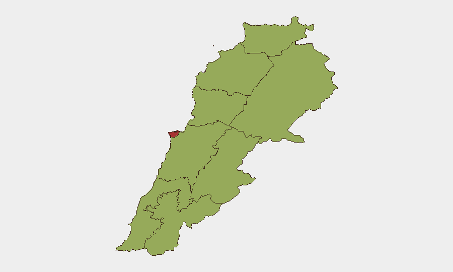
Lebanon remains at rank #22 globally in composite threat severity, with 27 tracked events signaling persistent political, sectarian, and regional tensions. The most recent 24–48 hour window (28–30 July) shows no clearly time-verified discrete security incidents in open-source monitoring, though underlying conditions—military posturing, diplomatic friction with Syria and Israel, UN disapproval, and domestic political strain—remain elevated. Beirut Governorate carries substantially higher risk (76.8) than all other regions, driven by concentration of state institutions, diplomatic presence, and population density. The current posture is best characterized as cautious stability rather than all-clear.
Key Developments
Late July 24–48h window: Open-source monitoring and GeoBit event signals indicate no fully corroborated, precisely timestamped security incidents (conflict, civil unrest, or travel-disruption events) in Lebanon for 28–30 July 2026. GeoBit's 25 July brief explicitly notes absence of reliably time-verified major discrete incidents in the preceding 48 hours, suggesting reduced acute kinetic activity but continued underlying tension.
Signal layer (28–29 July): Event feeds log diplomatic friction—Lebanese government demands directed at Syria (2 incidents, 29 July); UN disapproval of Lebanese actions (28 July); Israeli disapproval statements (28 July); U.S. threat communication toward Lebanon (28 July); and isolated physical assault attributed to Lebanese state vs. civilian (28 July, location and scale unspecified). Sectarian friction appears in Catholic vs. Maronite public statements (28 July). These signals indicate political and rhetorical escalation without confirmed kinetic incidents in the current window.
Interpretation: The absence of timestamped conflict/casualty reports in the last 48 hours stands in contrast to mid-July patterns (Israeli strikes, shelling, and airstrikes documented in early July). This may reflect temporary operational pause, reporting lag, or genuine reduction in acute incidents. Duty-of-care teams should treat apparent calm cautiously, given underlying military presence and diplomatic strain.
Highest-Risk Areas
Beirut Governorate (76.8) towers above all other regions—a gap of >29 points—reflecting capital-city concentration of government, banking, diplomatic, and international NGO infrastructure, as well as highest population density and historical pattern of sectarian and political violence. The second tier of governorates (North, Akkar, Keserwan-Jbeil, Mount Lebanon, South, Beqaa, Nabatieh, Baalbek-Hermel) all cluster at 46.8, indicating geographically distributed but secondary risk related to border proximity (Syria, Israel), Hizbollah presence, Palestinian refugee settlements, and inter-communal friction. The 30-point Beirut premium reflects both its strategic importance and operational environment for foreign nationals and corporate assets.
How GeoBit Would Assist
Security teams with personnel or assets in Lebanon should deploy AOI Monitoring & Early Warning (persistent watch on Beirut and secondary governorates with automated alerting on kinetic or political-volatility signals) coupled with OSINT Fusion & Corroboration (real-time cross-checking of event feeds, social media, and independent sources to filter noise from confirmed incidents). Routing & Network Analysis enables rapid alternative-route planning if mobility restrictions emerge, while Intel Sweep and multi-language sentiment analysis on Lebanese political discourse provide leading indicators of sectarian or state-level escalation before kinetic events occur.
7-Day Outlook
Diplomatic tension with Syria and low-level sectarian signaling suggest risk of incremental political friction rather than imminent major conflict. However, absence of timestamped incidents in the last 48 hours should not be interpreted as de-escalation; monitoring for Israeli or Syrian military activity along borders remains essential. Teams should sustain heightened alertness, especially in Beirut, while preparing contingency protocols for rapid staff movement if conditions shift.
Highest-Risk Areas — Ranked
| # | State / Region | Risk |
|---|---|---|
| 1 | Beirut Governorate | 76.8 |
| 2 | North Governorate | 47.5 |
| 3 | Akkar Governorate | 46.8 |
| 4 | Keserwan-Jbeil Governorate | 46.8 |
| 5 | Mount Lebanon Governorate | 46.8 |
| 6 | South Governorate | 46.8 |
| 7 | Beqaa Governorate | 46.8 |
| 8 | Nabatieh Governorate | 46.8 |
| 9 | Baalbek-Hermel Governorate | 46.8 |
Sources
Previous Daily Briefs
A new Lebanon brief is written every day — each with its own risk map and downloadable CSV. Here's the last week; use the calendar to go further back.
📅 Browse every day by calendar →
Highlighted days have a brief. Tap a day for that day's map & analysis, or “csv” for that day's dataset ($5).
Atlas — our AI intelligence desk — emails them this snapshot personally. Nothing else, no list.