Situation Summary
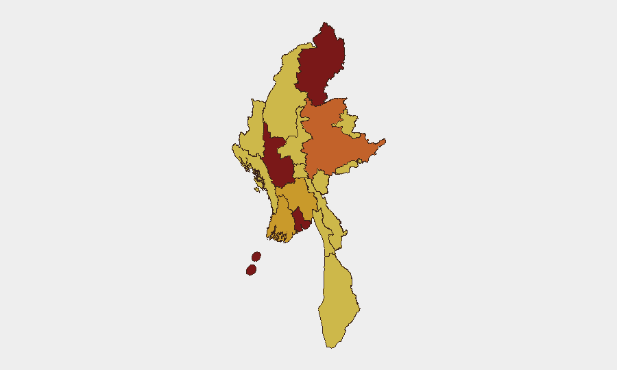
Myanmar remains in active civil war, with the military junta and aligned forces engaged in sustained conflict against a broad coalition of armed resistance movements across multiple regions. The country ranks #9 globally for composite threat risk (score 100), driven by fragmented but widespread armed hostilities, displacement, and state repression of media and civil society. No major new escalation has been verified in open sources over the past 24–48 hours; however, this reflects a data gap in real-time incident reporting rather than a reduction in underlying violence. Risk remains elevated across conflict zones and major urban centers.
Key Developments
Data Limitation Notice: Live open-source and commercial OSINT coverage for the past 24–48 hours has not yielded verifiable, time-stamped incident reports meeting operational confirmation standards. Recent event signals (7–11 July) reflect primarily administrative, judicial, and media-related actions (disapprovals, investigations, demands) rather than kinetic security incidents.
Context—Ongoing Impact (since early July, not 24–48h):
- Pakokku, Magway Region: Hostilities that began before 2 July 2026 have displaced over 20,000 people; humanitarian and security impacts remain active but incident details are not current within the brief window.
Recommended Response: Treat the absence of fresh incident detail as a surveillance gap, not assurance. Maintain operational alertness in high-risk zones; rely on routine monitoring for emerging activity rather than incident-driven alerts.
Highest-Risk Areas
Magway Region (risk 100) and Kachin State (89.1) drive the composite threat score, reflecting sustained armed conflict, displacement, and limited state control. Yangon (80.9), despite urban development, faces elevated risk from military suppression, arrest campaigns, and occasional civil unrest. Shan State (75.5), Ayeyarwady, Bago, and Tanintharyi regions are secondary conflict zones with armed activity, border instability, and logistical chokepoints. Mandalay and Rakhine round out the high-risk tier due to military presence, armed-group activity, and restricted civil freedoms. Northern and eastern border regions (Sagaing, Wa State, Chin) remain contested or ungoverned space with cross-border flows of combatants, weapons, and displaced persons.
How GeoBit Would Assist
Security teams should deploy AOI Monitoring & Early Warning on high-risk provinces (Magway, Kachin, Yangon, Shan) and border crossings to detect emerging hostilities before mainstream reporting. Conflict & Military capabilities (battle mapping, force-structure tracking) and OSINT fusion across Telegram, social feeds, and international humanitarian agencies enable early detection of displacement surges, supply-line disruptions, or command-level changes that precede major escalation. Routing & Network Analysis supports contingency planning for personnel evacuation or supply-chain rerouting around active conflict zones and administrative chokepoints.
7-Day Outlook
Armed resistance momentum remains sustained but fragmented; no imminent nationwide escalation is evident. However, localized intensity in Magway, Kachin, and Shan is expected to persist, with ongoing displacement and humanitarian strain. Military media suppression and arrest campaigns suggest authorities are managing information flow; security teams should anticipate continued communication blackouts and administrative obstruction in conflict zones. Risk of sudden, unverified incident activity remains high given surveillance gaps in remote areas.
Highest-Risk Areas — Ranked
| # | State / Region | Risk |
|---|---|---|
| 1 | Magway | 100 |
| 2 | Kachin State | 89.1 |
| 3 | Yangon | 80.9 |
| 4 | Shan State | 75.5 |
| 5 | Ayeyarwady | 72.7 |
| 6 | Bago Region | 72.7 |
| 7 | Tanintharyi Region | 70 |
| 8 | Chin | 70 |
| 9 | Sagaing Region | 70 |
| 10 | Wa State (Northern Region) | 70 |
| 11 | Mandalay | 70 |
| 12 | Rakhine | 70 |
Sources
Previous Daily Briefs
A new Myanmar brief is written every day — each with its own risk map and downloadable CSV. Here's the last week; use the calendar to go further back.
📅 Browse every day by calendar →
Highlighted days have a brief. Tap a day for that day's map & analysis, or “csv” for that day's dataset ($5).
Atlas — our AI intelligence desk — emails them this snapshot personally. Nothing else, no list.