Situation Summary
Niger remains a tier-2 global security concern (rank #20, composite score 94) with a highly fragmented risk profile dominated by terrorist activity in the northwest and ongoing civil-military tensions. The most recent confirmed incident—a 17 July attack on military personnel near Téra, Tillabéri Region, resulting in 16 soldier deaths—underscores persistent pressure on state forces along the Mali–Burkina Faso border. Professional security feeds report no new discrete incidents in the 24–48 hours since that attack, though the absence of fresh reporting does not indicate de-escalation; rather, it reflects operational gaps and delayed intelligence dissemination typical of the region.
Key Developments
- Téra, Tillabéri Region – 17 July 2026: Terrorist attack on ANP military deployment killed 16 soldiers and wounded 23 (9 seriously); 15 attackers were also killed. Location is proximate to Mali and Burkina Faso borders. Follow-on security sweeps were reported ongoing.
- Countrywide – 18–19 July monitoring cycle: Professional security assessments note no newly corroborated discrete incidents (attacks, protests, kidnappings, infrastructure disruption) across Niger in the immediate post-attack window. Assessment spans regional media, open-source feeds, and embassy advisories.
- Countrywide – 14–17 July prior cycle: French-language and English professional security bulletins confirm no location-specific, corroborated new security events during that earlier window, indicating the Téra incident was the primary tracked event in the reporting cycle.
- Event signal volatility – 20 July: GeoBit event signals logged six separate event categories within 24 hours (government demonstration, terrorist conventional military activity, cross-border threats from Ghana, and counter-operations by Niger). The clustering suggests reporting lag and multi-source signal overlap rather than simultaneous ground events.
Highest-Risk Areas
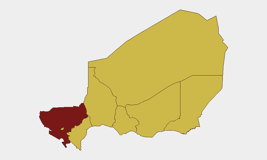
Tillabéri Region (score 95.6) is the dominant risk driver, reflecting sustained terrorist activity along the tri-border zone with Mali and Burkina Faso and the concentration of recent attack fatalities. The remaining seven administrative regions and the capital (Niamey) cluster at 65.6, indicating that while Tillabéri is exceptional, underlying instability is broadly distributed. The gap between Tillabéri and other regions suggests a geographic concentration of organized militant capability in the northwest, likely linked to Al-Qaeda and Islamic State splinter networks, while secondary regions face lower but persistent threats from residual cells, banditry, and civil unrest. Organizations with personnel or assets outside Tillabéri should treat that region as the primary kinetic risk; those in Niamey or secondary regions should monitor for spillover and opportunistic activity.
How GeoBit Would Assist
Security teams should employ Intel Sweep and multi-language OSINT fusion to corroborate fragmentary reports from Tillabéri and track terrorist actor movement across the tri-border zone. AOI Monitoring & Early Warning on Téra, Agadez, and Diffa regions—combined with Network & Actor Analysis of known militant cells—would provide 24–48 hour lead time on emerging threats. Conflict & Military battle mapping and GIS & Spatial Analysis would establish safe routing alternatives and identify secondary risk corridors for duty-of-care evacuation or supply-chain continuity planning.
7-Day Outlook
No significant de-escalation is expected; terrorist groups typically conduct follow-on operations 5–14 days after successful attacks. Tillabéri and Agadez remain critical watch zones. Monitoring for cross-border incursions from Mali and rhetoric from Ghana (per 20 July signal) should continue. Organizations should maintain heightened alertness for incident reporting delays and assume a 48–72 hour lag in open-source confirmation of new events.
Highest-Risk Areas — Ranked
| # | State / Region | Risk |
|---|---|---|
| 1 | Tillabéri Region | 95.6 |
| 2 | Agadez Region | 65.6 |
| 3 | Zinder Region | 65.6 |
| 4 | Diffa Region | 65.6 |
| 5 | Niamey | 65.6 |
| 6 | Tahoua Region | 65.6 |
| 7 | Dosso Region | 65.6 |
| 8 | Maradi Region | 65.6 |
Sources
Previous Daily Briefs
A new Niger brief is written every day — each with its own risk map and downloadable CSV. Here's the last week; use the calendar to go further back.
📅 Browse every day by calendar →
Highlighted days have a brief. Tap a day for that day's map & analysis, or “csv” for that day's dataset ($5).
Atlas — our AI intelligence desk — emails them this snapshot personally. Nothing else, no list.