Situation Summary
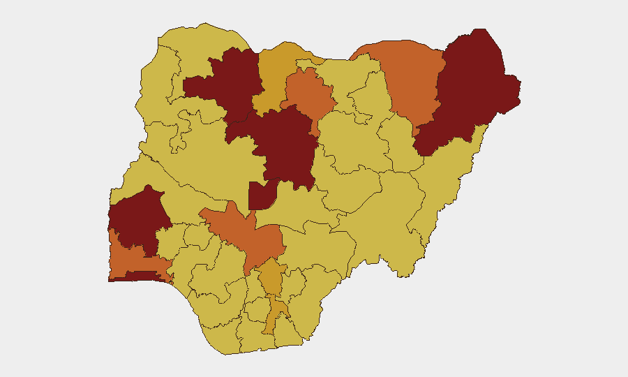
Nigeria remains the third-highest threat environment globally, driven primarily by active insurgency, kidnapping, and banditry across northern and south-western states. The past 24–48 hours have seen a nationwide police offensive yielding significant arrests and victim rescues, but kidnapping incidents continue to emerge across at least six states simultaneously, indicating sustained operational tempo by criminal and militant actors. Risk concentration in Oyo, Lagos, and Kaduna states reflects both urban crime escalation and north-central banditry pressure, with kidnapping now the dominant threat signature.
Key Developments
- Owerri, Imo State (20 July): Police foiled an active kidnapping, rescued seven victims unharmed, and recovered two vehicles after a firefight with suspects who fled into bush areas.
- Ondo State (20 July): Joint security team disrupted a kidnapping attempt, rescued the intended victim, and recovered spent AK-47 ammunition at the scene.
- Bauchi State (20 July): Police launched active manhunt using digital tracking tools following abduction of a young woman; rescue operations remain ongoing.
- Niger State (20 July): Multiple kidnapping and cattle-rustling incidents triggered police pursuit operations in rural areas; victim-rescue efforts in progress.
- Kwara, Kebbi, Nasarawa States (20 July): Active rescue and manhunt operations initiated across all three states in response to concurrent kidnapping incidents, signalling a broader north-central and north-western escalation.
- Ogun State (20 July): Intelligence-led investigations launched to track suspects linked to multiple residential armed-robbery incidents in urban areas.
- Nationwide police offensive (20 July): Nigeria Police Force reported 112 arrests, two kidnapped victims rescued, three firearms and 14 rounds of ammunition recovered, and one suspected kidnapper neutralised across 13 states and FCT in coordinated crackdown on cultism, armed robbery, kidnapping, homicide, banditry, and drug crimes.
- Bayelsa State (20 July): Detectives arrested a suspect in connection with alleged theft of government property valued at ₦500 million, indicating concurrent economic-crime enforcement.
Highest-Risk Areas
Oyo and Lagos states (risk scores 98.2 and 97.6 respectively) are the primary drivers of Nigeria's composite threat ranking, reflecting convergence of urban crime, organized banditry, and insurgency-adjacent activity. Kaduna State (94.2) remains a critical transit and operational corridor for north-south kidnapping networks. Borno and the Federal Capital Territory follow closely, but the simultaneous activation of kidnapping networks across Niger, Kwara, Kebbi, Bauchi, and Nasarawa in the past 24 hours suggests expansion of the banditry footprint from the traditional north-western belt into the north-central region, elevating risk in states previously ranked lower (Kogi, Nasarawa).
How GeoBit Would Assist
Security teams would employ AOI Monitoring & Early Warning to establish persistent watch on Oyo, Lagos, Kaduna, and the emerging north-central corridor, with automated alerting on kidnapping, banditry, and armed-robbery events. Routing & Network Analysis supports real-time alternative route planning and journey-risk assessment for personnel and supply movements, critical as incident hotspots shift. Intel Sweep and multi-source OSINT fusion across X, Telegram, and local news feeds enable continuous tracking of criminal-actor communications, demand patterns, and tactical shifts—essential for anticipating the next escalation wave.
7-Day Outlook
The volume and geographic spread of kidnapping incidents (six states active simultaneously) suggests organized criminal networks are sustaining or expanding operational capacity despite police counter-operations. Continued high-tempo police enforcement may disrupt near-term incidents but is unlikely to degrade underlying kidnapper networks. Corporate and NGO personnel should expect persistent abduction risk in transit corridors linking north-central and southern zones through July and into August.
Highest-Risk Areas — Ranked
| # | State / Region | Risk |
|---|---|---|
| 1 | Oyo State | 98.2 |
| 2 | Lagos State | 97.6 |
| 3 | Kaduna State | 94.2 |
| 4 | Borno State | 86.5 |
| 5 | Federal Capital Territory | 86.2 |
| 6 | Zamfara State | 82 |
| 7 | Kogi State | 74.8 |
| 8 | Kano State | 74.1 |
| 9 | Ogun State | 73.8 |
| 10 | Yobe | 73.5 |
| 11 | Enugu State | 72.7 |
| 12 | Abia State | 72.1 |
Sources
Previous Daily Briefs
A new Nigeria brief is written every day — each with its own risk map and downloadable CSV. Here's the last week; use the calendar to go further back.
📅 Browse every day by calendar →
Highlighted days have a brief. Tap a day for that day's map & analysis, or “csv” for that day's dataset ($5).
Atlas — our AI intelligence desk — emails them this snapshot personally. Nothing else, no list.