Situation Summary
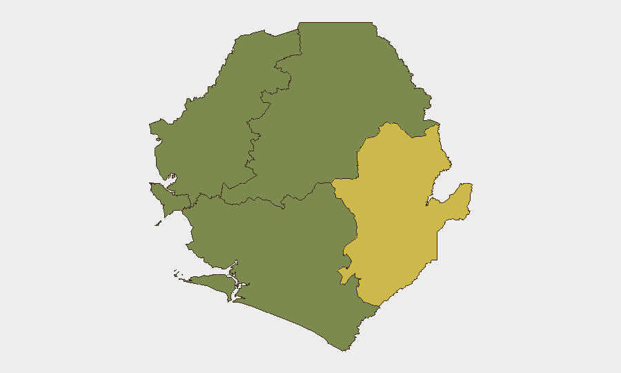
Sierra Leone remains a low–threat environment globally (rank #125, composite score 9) with no tracked violent security events in the current reporting window. However, acute political tension has emerged around a constitutional dispute in Parliament, scheduled for emergency debate on August 20, 2026, while infrastructure reliability issues and a recent arson incident in Kailahun District underscore localized vulnerabilities. The Eastern Province continues to present the highest sub-national risk (score 68), driven by remote geography, limited state presence, and cross-border factors; the Western Area (Freetown and surroundings) carries moderate risk (35) tied to political activity, port operations, and service disruptions.
Key Developments
- Freetown (Western Area) – August 17, 2026 – Emergency parliamentary summons issued. President Julius Maada Bio formally summoned Parliament for an emergency sitting on August 20 under Section 86(1) of the Constitution, following opposition walkout over the Constitution (Amendment) Bill 2025 and voting-threshold disputes. Political tension around central Freetown is elevated; Parliament precinct and adjacent areas warrant heightened situational awareness.
- Freetown (Western Area) – August 16, 2026 – Widespread power distribution faults. The Electricity Distribution and Supply Authority (EDSA) announced technical failures affecting 19 communities across Freetown and the Western Area, causing localized outages. Loss of street lighting and service disruption increases theft risk and complicates transit after dark.
- Kailahun District (Eastern Province) – August 16, 2026 – Arson attack on local infrastructure. Police Inspector General confirmed a recent arson incident targeting local infrastructure in Kailahun and announced proactive security measures in response. This represents a localized security concern in a region already classified as high-risk.
- Freetown – August 14, 2026 – Vehicle light ban enforcement begins. Sierra Leone Police issued a nationwide prohibition on decorative and colored vehicle lights, effective immediately. Enforcement activity at checkpoints may increase friction during vehicle stops, particularly in urban centers.
- Freetown – August 11–17, 2026 – Intensified anti-drug operations ongoing. Security forces destroyed 396 cartons of Tramadol and seized contraband at Water Quay and Hastings, reflecting continued enforcement around ports and transport infrastructure in greater Freetown.
- Falaba District (Northern border) – mid-August context – Sierra Leone–Guinea border demarcation dispute persists. Residents of Kaliyereh (Sulima Chiefdom) report ongoing disruption to farming, trade, and cross-border movement tied to unresolved border demarcation; this reflects low-level but chronic cross-border tension in the far north.
Highest-Risk Areas
Eastern Province (risk score 68) is the country's highest-risk zone, characterized by remoteness, weak state capacity, limited infrastructure, and proximity to Guinea. Western Area (score 35), centered on Freetown, carries acute near-term risk due to current political tension around Parliament and ongoing service failures affecting daily security and operations. Northern, North West, and Southern Provinces score zero on GeoBit's current assessment, indicating minimal tracked threat activity; however, the north's border dimensions warrant monitoring.
How GeoBit Would Assist
Corporate teams should employ AOI Monitoring & Early Warning on Parliament precinct and central Freetown during the August 20 emergency sitting to detect crowd movement or security incidents in real time. Routing & Network Analysis and multi-language OSINT (X, Telegram, local news feeds) would provide early signals of political escalation, infrastructure failures, or cross-border friction affecting travel corridors. Satellite and GIS spatial analysis of Eastern Province can track seasonal access constraints and validate security posture around Kailahun and border zones.
7-Day Outlook
The August 20 parliamentary emergency sitting carries the highest immediate risk; political temperature may rise if voting disputes intensify. Electricity faults and enforcement of the vehicle-light ban will likely persist, creating friction at checkpoints and reducing street security in affected areas. Absent significant new triggers, the security environment is expected to remain volatile but localized, with Eastern Province and Freetown requiring continued elevated monitoring.
Highest-Risk Areas — Ranked
| # | State / Region | Risk |
|---|---|---|
| 1 | Eastern Province | 68 |
| 2 | Western Area | 35 |
| 3 | North West Province, Sierra Leone | 0 |
| 4 | Northern Province, Sierra Leone | 0 |
| 5 | Southern Province, Sierra Leone | 0 |
Sources
Previous Daily Briefs
A new Sierra Leone brief is written every day — each with its own risk map and downloadable CSV. Here's the last week; use the calendar to go further back.
- August 15, 2026
- August 13, 2026
- August 11, 2026
- August 9, 2026
- August 7, 2026
- August 5, 2026
- August 4, 2026
📅 Browse every day by calendar →
Highlighted days have a brief. Tap a day for that day's map & analysis, or “csv” for that day's dataset ($5).
Atlas — our AI intelligence desk — emails them this snapshot personally. Nothing else, no list.