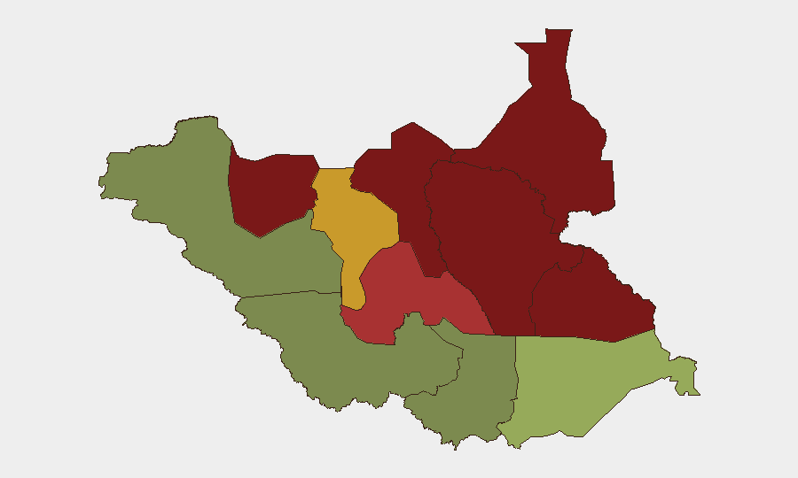
Situation Summary
South Sudan remains in a state of chronic armed conflict with active violence against civilians, primarily driven by communal cattle-raiding, inter-ethnic tensions, and fragmented armed groups across the northern and eastern regions. The composite national threat score of 65 reflects the endemic nature of violence; the past five days alone have documented three separate coordinated attacks resulting in 109+ civilian deaths across Warrap and Jonglei states. The security environment shows no signs of improvement and continues to deteriorate in the highest-risk northern states, with displacement, looting, and asymmetric attacks on civilian populations the dominant pattern.
Key Developments
- 2026-08-09, Warrap State (Tonj North County, Alabek Payam): Armed youth from Unity State conducted a coordinated assault on a cattle camp, killing 60+ civilians, wounding 50, and looting livestock and property. UNMISS confirmed the incident and documented significant civilian displacement in the aftermath.
- 2026-08-06, Warrap State (Tonj North County, Pan-Ariik/Akok Payam): A synchronized two-location armed assault resulted in 37 confirmed civilian deaths; part of a broader pattern of organized inter-county violence in the region.
- 2026-08-10, Unity State (Panyijiar and Mayendit counties, Wuriang Payam): Armed youth raided a cattle camp overnight, killing 12 civilians and seriously injuring an unconfirmed number. The incident aligns with Unity State's elevated threat profile and ongoing youth-militia activity.
- Upper Nile State (eastern areas, date non-specific in last 48h): UNMISS increased patrol activity following recent clashes between government and opposition armed groups; displaced populations reported returns to areas of relative stability, though security guarantees remain fragile.
- No verified discrete security incidents detected in the 24–48 hour window immediately preceding 2026-08-09. The current escalation cluster spans 2026-08-06 to 2026-08-10 and represents a surge in organized violence targeting civilian pastoral communities.
Highest-Risk Areas
Unity State (risk 95) and Jonglei State (risk 93) drive the majority of current threat activity, followed by Upper Nile (88) and Greater Pibor Administrative Area (87). All four regions are characterized by weak state authority, proliferation of armed youth militias, and systematic cattle-raiding operations that routinely cross administrative and ethnic boundaries. The Equatoria states and Western Bahr el Ghazal remain substantially lower-risk, with Central Equatoria (35) and Juba periphery offering relative security; however, teams transiting between safe and high-risk zones face exposure during movement.
How GeoBit Would Assist
Security teams would deploy AOI Monitoring & Early Warning on high-risk payams and cattle-camp corridors in Unity, Jonglei, and Upper Nile to detect militia mobilization and cross-border raiding patterns before attacks occur. Intel Sweep and OSINT fusion across Telegram, local radio SIGINT, and community networks would provide 12–36 hour pre-incident warnings of armed group movements. Routing & Network Analysis would identify safer transit corridors and timing for personnel or asset movement, while GIS & Spatial Analysis would map displacement zones, UNMISS presence, and humanitarian access points in real time.
7-Day Outlook
The pace and coordination of attacks in the past five days suggest the current violence may be sustained by planned militia operations rather than sporadic clashes. Without immediate mediation or military intervention at the state level, the pattern will likely continue across cattle-camp and pastoral routes in Warrap and Jonglei through mid-August, with secondary spillover risk into Lakes and Eastern Equatoria.
Highest-Risk Areas — Ranked
| # | State / Region | Risk |
|---|---|---|
| 1 | Unity | 95 |
| 2 | Jonglei | 93 |
| 3 | Upper Nile | 88 |
| 4 | Greater Pibor Administrative Area | 87 |
| 5 | Northern Bahr el Ghazal | 82 |
| 6 | Lakes | 78 |
| 7 | Warrap | 72 |
| 8 | Ruweng Administrative Area | 68 |
| 9 | Eastern Equatoria | 52 |
| 10 | Western Equatoria | 38 |
| 11 | Central Equatoria | 35 |
| 12 | Western Bahr el Ghazal State | 28 |
Sources
Previous Daily Briefs
A new South Sudan brief is written every day — each with its own risk map and downloadable CSV. Here's the last week; use the calendar to go further back.
- August 12, 2026
- August 11, 2026
- August 10, 2026
- August 9, 2026
- August 7, 2026
- August 6, 2026
- August 4, 2026
📅 Browse every day by calendar →
Highlighted days have a brief. Tap a day for that day's map & analysis, or “csv” for that day's dataset ($5).
Atlas — our AI intelligence desk — emails them this snapshot personally. Nothing else, no list.