Situation Summary
Sudan remains in acute civil war between the Sudanese Armed Forces (SAF) and the Rapid Support Forces (RSF), with fighting concentrated in Darfur, Kordofan, and Blue Nile states. The conflict has triggered widespread displacement, militia activity, and breakdown of state authority across at least 12 states. As of 25 July 2026, no verified incident-level reporting from the past 24–48 hours is available through open sources, though GeoBit's event signals indicate sustained military operations and civilian harm in Darfur on 22 July. The trajectory remains one of grinding, decentralized conflict with periodic intensity spikes and persistent humanitarian and security deterioration.
Key Developments
Open-source incident reporting for Sudan over the last 24–48 hours (23–25 July 2026) lacks the specificity and cross-verification required to cite individual events with confidence. GeoBit's event signals do confirm:
- 22 July, Darfur: Multiple signals of conventional military force involving SAF, RSF, residents, and civilian populations; at least two physical assault incidents (civilian vs. militia, and Darfur vs. civilian) recorded.
- 22 July, Darfur: Disapproval signals involving residents and gangs, consistent with secondary criminality and militia fragmentation during active conflict.
- 24 July: Governmental and international rejections (Sudan vs. Congress; Human Rights Watch vs. Congress; UNHCR) indicate continued diplomatic friction and alleged atrocities documentation.
For developments outside the 24–48h window but current to July 2026: SAF defense ministry claimed recent battlefield gains in Kordofan, Blue Nile, and Darfur; UN sources document intensified drone strikes (particularly around El-Obeid, North Kordofan); and convoy ambushes near the Sudan–Egypt–Libya border triangle have killed at least ten civilians. These represent the broader operational picture but are not time-stamped to the last two days.
Highest-Risk Areas
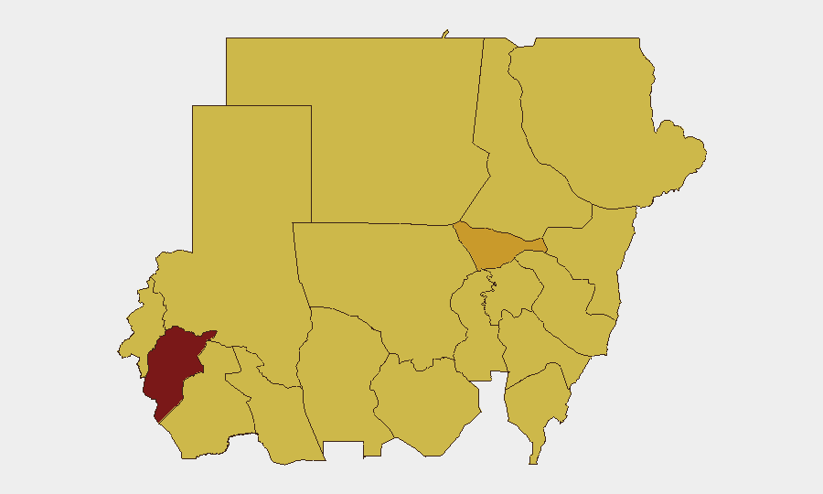
Central Darfur State (98.2) remains the single highest-risk zone globally and is the clear epicenter of Sudan's conflict, with sustained military operations, civilian assault, and militia activity. The top tier—Al Khartum (72.6), River Nile, Red Sea, and North Darfur (all 68.7+)—reflects fighting along the Nile corridor and Darfur periphery, where SAF–RSF contests for territorial and resource control intersect with civilian populations and border vulnerabilities. The clustering of ten states at 68.2 (Blue Nile, Aj Jazira, Al Qadarif, Kassala, Sennar, South Darfur, West Kordofan) indicates war has spread into a broad geographic band across central and eastern Sudan, with no region immune to military operations or secondary gang violence.
How GeoBit Would Assist
Organizations with people or assets in Sudan should deploy AOI Monitoring & Early Warning on their specific locations in high-risk states (especially Central Darfur, Al Khartum, and the Nile corridor) to receive real-time alerts on military activity, displacement, and security incidents. Battle Mapping and Force Structure analysis enables security teams to track SAF and RSF positions and anticipate operational shifts that may affect staff movement or supply routes. Routing & Network Analysis provides alternative journey planning and safe-passage assessment for staff evacuation or supply convoys, updated continuously as conflict lines shift.
7-Day Outlook
SAF–RSF fighting is likely to remain active and geographically dispersed through early August, with no indication of ceasefire or de-escalation. Intensity may fluctuate, but the risk of civilian harm, displacement, and secondary criminality will persist across Darfur, Kordofan, and Blue Nile. Duty-of-care posture should remain at elevated alert, with contingency for rapid staff movement or facility closure if fighting nears operational areas.
Highest-Risk Areas — Ranked
| # | State / Region | Risk |
|---|---|---|
| 1 | Central Darfur State | 98.2 |
| 2 | Al Khartum | 72.6 |
| 3 | River Nile State | 68.7 |
| 4 | Red Sea State | 68.7 |
| 5 | North Darfur State | 68.7 |
| 6 | Blue Nile | 68.2 |
| 7 | Aj Jazira | 68.2 |
| 8 | Al Qadarif State | 68.2 |
| 9 | Kassala State | 68.2 |
| 10 | Sennar State | 68.2 |
| 11 | South Darfur State | 68.2 |
| 12 | West Kurdufan State | 68.2 |
Sources
Previous Daily Briefs
A new Sudan brief is written every day — each with its own risk map and downloadable CSV. Here's the last week; use the calendar to go further back.
📅 Browse every day by calendar →
Highlighted days have a brief. Tap a day for that day's map & analysis, or “csv” for that day's dataset ($5).
Atlas — our AI intelligence desk — emails them this snapshot personally. Nothing else, no list.