Situation Summary
Syria remains a complex operating environment characterized by overlapping security pressures: counter-terrorism operations in the capital and provinces, recurring cross-border military incursions from Israeli forces, and deteriorating infrastructure and service delivery in outlying regions. Recent terrorist attacks near Damascus have triggered sustained security-service sweeps and heightened law-enforcement activity across multiple governorates. The threat landscape reflects both organized militant activity and localized civil unrest driven by economic and governance failures, creating a fragmented but persistently elevated risk profile.
Key Developments
- Damascus city & countryside (July 9, 2026): Syrian security services conducted simultaneous raids across four neighborhoods in Damascus and surrounding areas, arresting a cell assessed as ISIL-linked and responsible for the July 7 twin bombings near the Four Seasons Hotel during a French presidential visit. Interior Minister Anas Khattab confirmed custody of the suspects via state media and social channels.
- Quneitra province (July 9, 2026, evening): More than 15 Israeli military vehicles entered the village of Al-Asha near the occupied Golan Heights, conducted house and facility searches, then withdrew. No casualties or arrests reported, but operation extends a pattern of recent cross-border incursions raising travel and security risk in southern Syria.
- Quneitra province (July 9, 2026, daytime): Israeli forces entered the village of Saida al-Golan, established a temporary checkpoint at the village entrance, and later withdrew—characterized by Syrian media as a sovereignty violation and indicator of continued military friction in the zone.
- Hama province, al-Ghab region (July 12, 2026): Internal Security Forces dismantled a criminal assassination cell, arresting all seven members. One detainee confessed to involvement in the killing of a Salhab resident; authorities report ongoing efforts to identify additional suspects.
- Al-Darbasiyah, Hasakah governorate (reported July 15, 2026): A fuel crisis has paralyzed the town with power outages entering their third day, affecting basic services and raising operational and travel risks in northeastern Syria.
- Southern Hasakah province (reported July 15, 2026): Residents held protests over deteriorating service conditions, including shortages and poor infrastructure, reflecting localized civil unrest and governance grievances.
- Deir ez-Zor (reported July 15, 2026): Death toll from a ferry sinking reached six people in the preceding 24 hours, highlighting persistent safety and infrastructure hazards on river crossings.
- Nationwide road network (reported July 15, 2026): Syrian traffic authorities reported one death and 27 injuries in 19 traffic accidents in the previous 24 hours, underscoring road-safety and emergency-response risks for overland travel.
Highest-Risk Areas
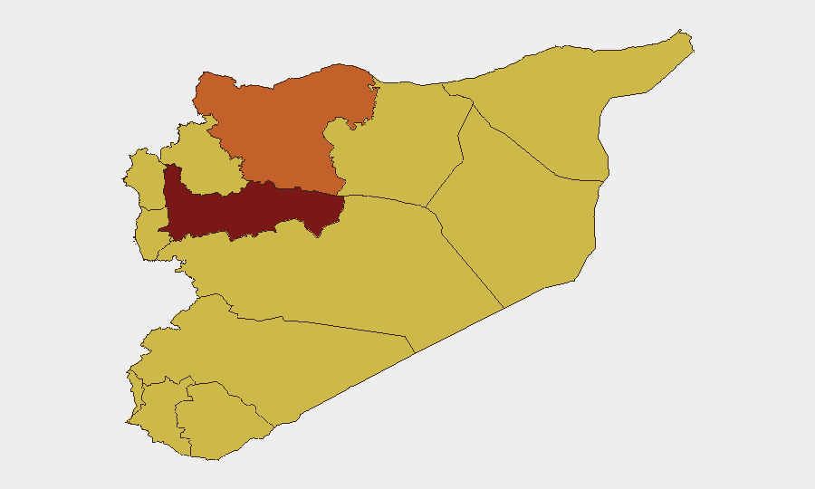
Hama Governorate (98.5) leads the sub-national ranking and reflects both active law-enforcement operations against organized criminal and militant cells and underlying infrastructure vulnerabilities. Damascus Governorate (73.7) and Aleppo Governorate (73.4) follow, with Damascus driven by counter-terrorism sweeps following the July 7 attacks and Aleppo by structural instability. Al-Hasaka Governorate (70.8) ranks fourth, affected by fuel shortages, power outages, and civil unrest in southern districts. The coastal and southern governorates (Tartus, Lattakia, Dar'a, Idleb, Al-Quneitra) all register 68.5, reflecting cross-border military friction, governance gaps, and infrastructure deterioration. The UNDOF zone likewise scores 68.5, driven by Israeli incursions and checkpoint activity.
How GeoBit Would Assist
Organizations with personnel or assets in Syria should employ AOI Monitoring & Early Warning to track high-risk governorates—particularly Hama, Damascus, and Al-Hasaka—with persistent alerting for security incidents, civil unrest, and service disruptions. Routing & Network Analysis supports identification of safer overland corridors and real-time alternative routes around cross-border incursion zones and checkpoint activity in the south. Conflict & Military capability, combined with OSINT fusion (X/Twitter, local media, radio SIGINT), enables near-real-time tracking of Israeli force movements, Syrian counter-terror operations, and infrastructure failures that affect duty-of-care obligations.
7-Day Outlook
Counter-terrorism operations in Damascus and Hama are likely to persist as authorities continue detainee interrogations and identify additional suspects. Israeli incursions into the Golan Heights zone should be expected to continue at lower intensity unless regional escalation occurs. Infrastructure crises in Al-Hasaka and service-delivery protests across northern and northeastern zones will remain localized but may slow civilian movement and logistics operations.
Highest-Risk Areas — Ranked
| # | State / Region | Risk |
|---|---|---|
| 1 | Hama Governorate | 98.5 |
| 2 | Damascus Governorate | 73.7 |
| 3 | Aleppo Governorate | 73.4 |
| 4 | Al-Hasaka Governorate | 70.8 |
| 5 | Tartus Governorate | 69 |
| 6 | Lattakia Governorate | 68.5 |
| 7 | UNDOF | 68.5 |
| 8 | Al-Quneitra Governorate | 68.5 |
| 9 | Dar'a Governorate | 68.5 |
| 10 | Idleb Governorate | 68.5 |
| 11 | Ar-Raqqa Governorate | 68.5 |
| 12 | Homs Governorate | 68.5 |
Sources
Previous Daily Briefs
A new Syria brief is written every day — each with its own risk map and downloadable CSV. Here's the last week; use the calendar to go further back.
📅 Browse every day by calendar →
Highlighted days have a brief. Tap a day for that day's map & analysis, or “csv” for that day's dataset ($5).
Atlas — our AI intelligence desk — emails them this snapshot personally. Nothing else, no list.