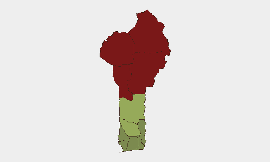
Situation Summary
Benin's security environment remains moderately elevated, with the composite national threat score of 37 (ranked #52 globally) primarily driven by persistent insurgency and terrorism activity in the northern departments. No major security incidents were recorded during the week of October 13–19, though localized crime and communal tensions continue to pose risk to civilian populations and commercial operations. The country's risk profile is heavily concentrated in the north, where armed group activity and cross-border pressures from Mali and Burkina Faso create sustained operational hazards.
Key Developments
- Djougou, Kilir neighborhood — 16 October 2026: Police dismantled a clandestine pharmaceutical depot and seized 243.4 kg of counterfeit and informal medicines. A suspected couple was detained; a third suspect remains at large. The operation signals ongoing organized trafficking in falsified medical supplies affecting public health and potential corporate supply-chain integrity.
- Angaradébou, Kandi commune — 13 October 2026: A farmer was fatally attacked with a machete while returning from fields. Residents conducted retaliatory violence against a suspected member of the Fulani community, burning several homes. Police evacuated the suspect's father and restored calm. The incident underscores persistent communal tensions and the risk of escalation through vigilante action in rural northern areas.
Highest-Risk Areas
The northern departments of Alibori (risk 92), Atakora (88), Donga (85), and Borgou (83) account for the overwhelming majority of Benin's threat profile. These zones are characterized by active or residual insurgent presence, cross-border infiltration from jihadist groups operating in Mali and Burkina Faso, and limited state capacity for sustained security operations. The central and southern departments—Zou, Collines, Plateau, and Kouffo (risk scores 45–35)—experience secondary levels of organized crime and petty violence but remain substantially safer for commercial and diplomatic operations. Littoral, Ouémé, and Atlantique departments (risk 22–28) are the lowest-risk zones and include the capital Cotonou and primary port infrastructure.
How GeoBit Would Assist
Security and risk teams operating in Benin would benefit from AOI Monitoring & Early Warning on the four highest-risk northern departments to track emerging armed group activity and cross-border incursions with real-time alerting. Intel Sweep and multi-language OSINT fusion would enable continuous monitoring of local reporting on communal violence, criminal networks (as evidenced by the pharmaceutical trafficking case), and state-capacity developments that signal deterioration or stabilization. Routing & Network Analysis would support duty-of-care teams in identifying secure alternative routes for personnel and supply movements, particularly in transit between southern commercial hubs and any northern operations.
7-Day Outlook
No imminent major security deterioration is indicated for the coming week; however, the localized nature of recent incidents (pharmacy trafficking, farmer homicide, communal retaliation) reflects structural vulnerabilities in rule of law and intercommunal relations rather than acute crisis indicators. Northern departments will remain under sustained monitoring pressure, and any escalation of armed group activity across Burkina Faso or Mali borders could transmit rapidly into Alibori and Atakora. Corporate and diplomatic personnel should maintain heightened vigilance in northern operations and rely on updated routing intelligence for any essential travel.
Highest-Risk Areas — Ranked
| # | State / Region | Risk |
|---|---|---|
| 1 | Alibori Department | 92 |
| 2 | Atakora Department | 88 |
| 3 | Donga Department | 85 |
| 4 | Borgou Department | 83 |
| 5 | Zou Department | 45 |
| 6 | Collines Department | 42 |
| 7 | Plateau Department | 38 |
| 8 | Kouffo Department | 35 |
| 9 | Mono Department | 32 |
| 10 | Atlantique Department | 28 |
| 11 | Littoral | 25 |
| 12 | Ouémé Department | 22 |
Sources
Previous Weekly Briefs
A new Benin brief is written every Monday, covering the week — each with its own risk map and downloadable CSV. Use the calendar to go further back.
- October 12, 2026
- October 5, 2026
- September 28, 2026
- September 21, 2026
- September 14, 2026
- September 7, 2026
- September 1, 2026
📅 Browse past briefs by calendar →
Highlighted days have a brief. Tap a day for that day's map & analysis, or “csv” for that day's dataset ($5).
Atlas — our AI intelligence desk — emails them this snapshot personally. Nothing else, no list.