Situation Summary
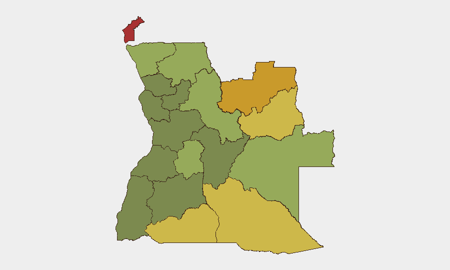
Angola remains at moderate overall risk (rank #55 globally, composite score 32) with no reported armed conflict, civil unrest, or nationally significant security incidents in the past 24–48 hours. The security picture is dominated by structural, region-specific threats rather than acute national crises. Risk is heavily concentrated in the diamond-rich and border provinces of the northeast and southeast, where weak state presence, armed group activity, and cross-border trafficking create persistent vulnerability.
Key Developments
- No corroborated armed clashes, protests, terror incidents, or major crime events were reported across Angola during 2026-08-06 to 2026-08-07.
- No critical national infrastructure disruption (airports, ports, power grid) was reported in the past 24–48 hours.
- Routine baseline security posture continues nationwide; monitoring shows no escalation from earlier in the week.
- Recent (pre-24h) cyber exposure: A coordinated cyberattack on Unitel's telecommunications infrastructure occurred on 2026-07-28, disrupting mobile voice services—this remains the most recent significant incident but occurred outside the immediate 24–48 hour window.
- Recent (pre-24h) infrastructure accident: A vehicle collision with an electrical pole caused localized power disruption and minor traffic impact in Talatona, Luanda on 2026-08-05 (classified as accidental).
- Recent (pre-24h) custodial incident: An accidental firearm discharge at Calomboloca Penitentiary on 2026-08-05 resulted in one officer death and one injury (classified as internal/accidental).
- Northern and eastern border regions remain the structural focus of open-source monitoring, but no fresh incident was corroborated in the last reporting cycle.
Highest-Risk Areas
Cabinda Province (risk 78) and the Lunda Norte and Lunda Sul provinces (72 and 68 respectively) drive Angola's subnational risk profile. These northeastern and eastern territories are characterized by diamond-mining activity, porous international borders, limited state capacity, and history of armed group presence and cross-border trafficking networks. The southeastern provinces—Cuando Cubango (64), Cunene (62), and Moxico (58)—present secondary risk clusters along the Namibian border and in remote areas with weak governance. By contrast, central provinces (Bié, 35) and the capital region (Luanda, not separately ranked but operationally lower-risk) show substantially lower threat indices and more stable security environments.
How GeoBit Would Assist
Corporate teams with personnel or assets in Angola should employ AOI Monitoring & Early Warning on Cabinda and the Lunda provinces to detect emerging armed group activity, trafficking movements, or cross-border incidents in real time. Network & Actor Analysis combined with multi-language OSINT and social-media intelligence (X, Telegram) will surface regional power brokers, militia leaders, and trafficking networks operating in diamond zones. GIS & Spatial Analysis with satellite imagery can track infrastructure vulnerabilities, camp movements, and supply-line changes in remote operating areas.
7-Day Outlook
No escalation is forecast for the immediate week absent new external triggers (e.g., regional conflict spillover or major criminal incident). Risk in the northeast and southeast will remain chronic and geographically concentrated rather than acute. Duty-of-care teams should maintain heightened baseline protocols in Cabinda and Lunda provinces and monitor telecommunications and power resilience in Luanda following the late-July Unitel attack.
Highest-Risk Areas — Ranked
| # | State / Region | Risk |
|---|---|---|
| 1 | Cabinda Province | 78 |
| 2 | Lunda Norte Province | 72 |
| 3 | Lunda Sul Province | 68 |
| 4 | Cuando Cubango Province | 64 |
| 5 | Cunene Province | 62 |
| 6 | Moxico Province | 58 |
| 7 | Zaire Province | 54 |
| 8 | Huambo Province | 50 |
| 9 | Uíge Province | 48 |
| 10 | Malanje Province | 42 |
| 11 | Bié Province | 35 |
| 12 | Huíla Province | 32 |
Sources
Previous Daily Briefs
A new Angola brief is written every day — each with its own risk map and downloadable CSV. Here's the last week; use the calendar to go further back.
📅 Browse every day by calendar →
Highlighted days have a brief. Tap a day for that day's map & analysis, or “csv” for that day's dataset ($5).
Atlas — our AI intelligence desk — emails them this snapshot personally. Nothing else, no list.