Situation Summary
China's security environment remains dominated by natural-hazard and infrastructure risks rather than civil unrest or political instability. A major landslide in Chongqing (Pengshui County) on 17 July killed 8 and left 34 missing as of 18 July, while severe flooding across Jilin Province and northeastern coastal regions—driven by Typhoon Bavi—continues to disrupt travel and critical infrastructure. No large-scale civil unrest, major political incidents, or terrorism events have been reported in the last 48 hours; however, intensified state censorship of disaster-related social media and ongoing maritime friction in the South China Sea remain secondary risk vectors.
Key Developments
- Pengshui Miao and Tujia Autonomous County, Chongqing – landslide collapse, 17 July. Mountain collapse buried residential buildings downhill; 18 rescued, 8 confirmed dead, 34 missing as of latest official update (18 July). Search-and-rescue operations ongoing with significant terrain and safety constraints reported.
- Jilin Province – flood response escalation, 14–18 July. Emergency management authorities upgraded flood response from Level IV to Level III due to heavy rainfall and severe flooding; conditions remain critical with infrastructure and travel disruption expected to persist through the current reporting window.
- Northeastern and eastern coastal regions – Typhoon Bavi impacts, ongoing. Severe weather and associated flooding dominate the national operational picture; primary concern is infrastructure damage and travel delay over the next 48–72 hours.
- Nationwide – online censorship campaign, 13–18 July. Cyber police announced detention of 4 individuals and administrative penalties for 23 others related to alleged "disaster rumors"; enforcement reportedly intensifying across social platforms, with rapid removal of flood, labor dispute, and protest footage. Legal exposure for residents and workers posting incident documentation.
- South China Sea – PLA and China Coast Guard patrols near Huangyan Dao (Scarborough Shoal), 14 July onward. Combat-readiness and law-enforcement operations reported; PLA Navy frigate operations against foreign warship in subsequent days indicate ongoing maritime friction and elevated risk to shipping and offshore operations.
Highest-Risk Areas
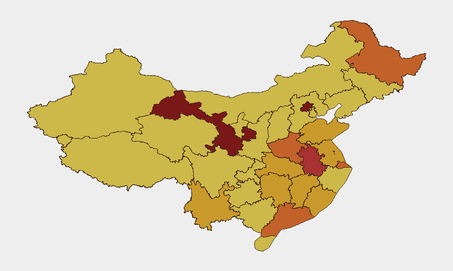
Gansu (100), Beijing (91.4), and Anhui (77.5) lead GeoBit's sub-national ranking, though the current acute life-safety and infrastructure crisis centers on Chongqing (unranked separately but host to the Pengshui landslide) and Jilin Province in the northeast. These areas face immediate hazard from ongoing rescue operations, terrain instability, and severe flooding. Beijing's elevated score likely reflects political-institutional volatility and intelligence activity; Gansu's top ranking suggests long-standing economic stress, minority-Han friction, or cross-border movement. The concentration of maritime risk in southern coastal zones (Guangdong, Shanghai periphery) underscores exposure to South China Sea friction and typhoon disruption.
How GeoBit Would Assist
Teams with personnel or assets in affected regions should deploy AOI Monitoring & Early Warning on Chongqing, Jilin, and coastal provinces to track rescue operations, infrastructure restoration, and secondary hazards (afterslips, flooding). GIS & Spatial Analysis and Satellite & Imagery analysis enable real-time assessment of landslide extent, road/utility damage, and population displacement. Multi-language search, social-media OSINT (X/Telegram), and sentiment analysis identify emerging unrest linked to disaster response failures or censorship backlash—often precursors to wider instability—while routing and network analysis supports safe travel re-planning around closed corridors.
7-Day Outlook
Chongqing rescue operations will remain the dominant life-safety focus; continued heavy rain increases secondary landslide and flooding risk. Typhoon Bavi's effects are expected to ease by 20–22 July, but regional infrastructure strain will persist. No indication of imminent political crisis or civil unrest, though prolonged disaster-response friction and online censorship enforcement warrant close monitoring for delayed grievance mobilization.
Highest-Risk Areas — Ranked
| # | State / Region | Risk |
|---|---|---|
| 1 | Gansu | 100 |
| 2 | Beijing | 91.4 |
| 3 | Anhui | 77.5 |
| 4 | Shanghai | 75.2 |
| 5 | Henan | 73.8 |
| 6 | Heilongjiang | 73.6 |
| 7 | Guangdong Province | 73.4 |
| 8 | Shandong | 72.9 |
| 9 | Hunan | 72.5 |
| 10 | Jiangxi | 72.3 |
| 11 | Jiangsu | 72.1 |
| 12 | Hubei | 71.7 |
Sources
Previous Daily Briefs
A new China brief is written every day — each with its own risk map and downloadable CSV. Here's the last week; use the calendar to go further back.
📅 Browse every day by calendar →
Highlighted days have a brief. Tap a day for that day's map & analysis, or “csv” for that day's dataset ($5).
Atlas — our AI intelligence desk — emails them this snapshot personally. Nothing else, no list.