Situation Summary
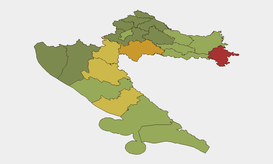
Croatia remains a low-threat environment (global rank #151; composite score 7) with no confirmed security events in the current 24–48-hour window. Wildfire activity in the Dubrovnik and Bosnia–Croatia border zone (2026-08-23) disrupted regional transport but posed no direct security threat to personnel or assets. Overall trajectory is stable; risk remains concentrated in the eastern border counties and areas with legacy environmental or infrastructural vulnerabilities.
Key Developments
- Dubrovnik / Bosnia–Croatia border — 2026-08-23 — Large wildfire prompted Bosnian authorities to close the main highway to Dubrovnik, disrupting tourist and commercial vehicle movement. Multiple Euronews reports confirmed the closure; no casualties or security incidents reported. Route diversions remain in effect pending fire containment.
- No confirmed discrete security incidents (24–48h window) — As of 2026-08-28 09:00 UTC, no independently corroborated armed, criminal, protest-related, or cyber incidents were identified in Croatia proper during the last 48 hours. This represents continuity with the broader low-threat baseline.
- Zadar area wildfire activity (background context) — Earlier reports (2026-08-22) of a plane crash near Zadar were not substantiated by a second source and fall outside the current assessment window; no follow-up confirmation available.
- Split protest announcement — A protest was announced for 2026-08-27 in Split (Pujanke 34) over local grievances; confirmation of actual occurrence was not obtained, and no disruptions or unrest were reported.
- Regional environmental factors — Persistent drought and heat conditions across southern and eastern Croatia continue to elevate wildfire risk, particularly in Split-Dalmatia, Zadar, and Šibenik-Knin counties. Road closures and air-quality alerts remain possible but are classified as environmental-safety matters, not security threats.
Highest-Risk Areas
Eastern border counties—Vukovar-Srijem (78), Sisak-Moslavina (72), and Karlovac (68)—drive the national composite risk ranking. These regions reflect legacy border tensions, residual demographic fragmentation, and infrastructure challenges dating to the 1990s conflict period. Western Adriatic counties (Lika-Senj, Šibenik-Knin, Zadar) rank elevated due to wildfire exposure, seasonal tourism volatility, and maritime-boundary complexity. Zagreb (rank 9, score 50) reflects routine urban crime and protest activity typical of a capital city. No imminent escalation is signaled.
How GeoBit Would Assist
AOI Monitoring & Early Warning would provide persistent watch on Vukovar-Srijem and Sisak-Moslavina counties for border-related incidents, with automated alerting. Multi-language OSINT and Intel Sweep capabilities enable 24-hour scanning of local police, municipal, and regional media to detect emerging security, protest, or infrastructure events before they affect operations. Routing & Network Analysis supports real-time journey planning around active wildfires or road closures in the Adriatic counties, minimizing exposure to disrupted corridors.
7-Day Outlook
Fire season activity will likely persist through early September across southern and central regions; additional temporary road closures are foreseeable but manageable. No political, criminal, or conflict escalation is anticipated. Personnel and asset security postures should remain routine, with heightened attention to environmental hazards (heat, air quality, wildfire smoke) and transport routing in coastal and border zones.
Highest-Risk Areas — Ranked
| # | State / Region | Risk |
|---|---|---|
| 1 | Vukovar-Srijem County | 78 |
| 2 | Sisak-Moslavina County | 72 |
| 3 | Karlovac County | 68 |
| 4 | Lika-Senj County | 65 |
| 5 | Šibenik-Knin County | 62 |
| 6 | Brod-Posavina County | 58 |
| 7 | Zadar County | 55 |
| 8 | Osijek-Baranja County | 52 |
| 9 | City of Zagreb | 50 |
| 10 | Split-Dalmatia County | 48 |
| 11 | Požega-Slavonia County | 45 |
| 12 | Virovitica-Podravina County | 42 |
Sources
Previous Daily Briefs
A new Croatia brief is written every day — each with its own risk map and downloadable CSV. Here's the last week; use the calendar to go further back.
- August 26, 2026
- August 24, 2026
- August 22, 2026
- August 20, 2026
- August 18, 2026
- August 16, 2026
- August 14, 2026
📅 Browse every day by calendar →
Highlighted days have a brief. Tap a day for that day's map & analysis, or “csv” for that day's dataset ($5).
Atlas — our AI intelligence desk — emails them this snapshot personally. Nothing else, no list.