Situation Summary
Iran faces an acute security escalation following the collapse of a ceasefire on 9 July. The U.S. has conducted large-scale airstrikes across southern Iran over a 48-hour window (9–11 July), targeting approximately 90–180 military sites and killing at least 14 civilians with 78 wounded. Tehran has issued formal diplomatic condemnation and internal security alerts, while geopolitical tensions involving NATO, the UK, and EU aviation regulators have intensified. The threat environment is now at critical levels across multiple southern provinces and Tehran, with risk of further escalation in coming days.
Key Developments
- Bushehr Nuclear Power Plant perimeter – 10–11 July: U.S. projectile struck the perimeter area; Iranian officials reported damage but no casualties to date. This marks the first direct strike on or near critical nuclear infrastructure in the current escalation cycle.
- Khuzestan Province – 10 July: U.S. airstrikes killed at least three people; Khuzestan (risk score 73.4) remains under active bombardment as part of the broader two-day strike campaign.
- Iranshahr Airport, Sistan and Baluchestan – 10 July: U.S. strike on airport infrastructure killed a firefighter; part of the 14-person nationwide death toll over 48 hours.
- Nationwide U.S. strike campaign – 9–11 July: Two consecutive nights of intensive U.S. air operations targeting military infrastructure across southern Iran; Iranian state media and Health Ministry confirmed 14 dead, 78 wounded; ceasefire formally collapsed.
- Iranian Ministry of Foreign Affairs statement – 10–11 July: Official condemnation of "criminal attacks by the United States" framed as unjustified responses to maritime incidents; heightens diplomatic pressure and internal mobilization rhetoric.
- Coastal communities, southern Iran – nights 9–10 July: Residents reported "48 hours of terror" as strikes targeted multiple coastal areas; civilian impact and psychological toll documented across Hormozgan and adjacent provinces.
- Strait of Hormuz maritime zone – 10–11 July: No new confirmed sailor deaths in latest 24-hour window, though overall civilian maritime toll since April ceasefire stands at 13; indicates military focus but no new maritime casualties in immediate reporting window.
Highest-Risk Areas
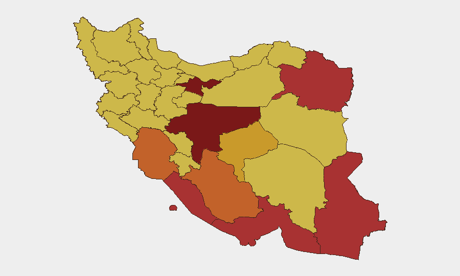
Tehran Province (risk 100) remains the command-and-control and symbolic center, though active military targeting is concentrated in the south. Isfahan (89.2), Bushehr (79.7), and the southeastern provinces of Razavi Khorasan (78.3), Hormozgan (76.5), and Sistan and Baluchestan (76.4) now face the highest operational risk due to active U.S. strike activity, critical infrastructure exposure (notably Bushehr nuclear), and sustained military presence. Khuzestan and Fars provinces show elevated risk from ongoing airstrikes and proximity to maritime flashpoints. Risk scores reflect both recent kinetic activity and underlying infrastructure/geopolitical significance.
How GeoBit Would Assist
Security teams should employ Battle Mapping & Force Structure tracking to monitor U.S. and Iranian military posture in real time; AOI Monitoring & Early Warning on Tehran, Bushehr, and coastal provinces for strike activity and civilian impacts; and Conflict & OSINT intelligence sweeps (X/Twitter, Iranian state media, multi-language feeds) to capture casualty updates, official statements, and early signals of further escalation or de-escalation. Routing & Network Analysis can identify alternative transport corridors avoiding strike zones for personnel and cargo movement.
7-Day Outlook
The immediate 7-day window carries elevated risk of continued or renewed U.S. strikes if Iranian retaliation or maritime incidents occur. Iranian domestic pressure for a response, combined with diplomatic isolation, may drive tactical escalation (missile or drone activity, maritime incidents) rather than immediate de-escalation. International diplomatic engagement and any ceasefire renegotiation are unlikely within 48–72 hours; security posture should remain at heightened readiness across all southern and Tehran-based operations.
Highest-Risk Areas — Ranked
| # | State / Region | Risk |
|---|---|---|
| 1 | Tehran Province | 100 |
| 2 | Isfahan Province | 89.2 |
| 3 | Bushehr Province | 79.7 |
| 4 | Razavi Khorasan | 78.3 |
| 5 | Hormozgan Province | 76.5 |
| 6 | Sistan and Baluchestan Province | 76.4 |
| 7 | Fars Province | 74.2 |
| 8 | Khuzestan Province | 73.4 |
| 9 | Yazd Province | 71.7 |
| 10 | Mazandaran Province | 70.8 |
| 11 | Semnan Province | 70.7 |
| 12 | Qom Province | 70.7 |
Sources
Previous Daily Briefs
A new Iran brief is written every day — each with its own risk map and downloadable CSV. Here's the last week; use the calendar to go further back.
📅 Browse every day by calendar →
Highlighted days have a brief. Tap a day for that day's map & analysis, or “csv” for that day's dataset ($5).
Atlas — our AI intelligence desk — emails them this snapshot personally. Nothing else, no list.