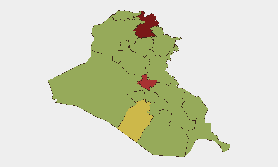
Situation Summary
Iraq faces a complex, multi-vector security environment characterized by active Iran–Iraq military tensions, persistent insurgent activity in the north, and militia threat activity against Western interests in Baghdad. As of 23 July 2026, the country ranks #15 globally in composite threat score (81/100), driven primarily by ongoing insurgency across 359 tracked events. The security picture reflects both state-level interstate friction and sub-national armed group volatility, with risk heavily concentrated in the Kurdistan Region (Erbil Governorate at 86.7/100) and the capital.
Key Developments
- Erbil Governorate – 23 Jul 2026: Small arms combat reported in Arbil; concurrent conventional military force activity between Iraq and Iran, with Iranian artillery/tank operations also confirmed on the same date. Erbil remains the highest-risk sub-national zone.
- Iraq–Iran Border – 23 Jul 2026: Multiple hostile signals on the same day: conventional military force engagement (Iraq vs. Iran), Iranian artillery/tanks, and unconventional violence activity. No casualty counts available; escalation trajectory unclear.
- Baghdad – 23 Jul 2026: Iraqi security forces conducted arrest/detain operations; concurrently, an investigative action by Iraqi authorities targeting Baghdad was initiated. Context: U.S. Embassy issued urgent militia-attack warnings on 19 July, advising evacuation within 24–48 hours, suggesting ongoing pressure on Western personnel.
- Kurdistan Region – 19 Jul 2026: Drone activity and interceptions reported over Erbil and Sulaymaniyah, with no reported casualties. Temporary export disruptions noted at Basra crude terminal and Faw port due to drone incidents near southern oil infrastructure.
- Zaidi Entity – 23 Jul 2026: Public statement issued by an envoy regarding Zaidi; context limited, but classified as an event signal requiring monitoring.
- Territorial Control – 22 Jul 2026: Iraqi forces reported occupying territory in a Shiite-majority area; military operations continued on 22 July across multiple fronts.
Highest-Risk Areas
Erbil Governorate (86.7/100) and Baghdad Governorate (79/100) dominate the risk landscape, together accounting for the majority of acute threat drivers. Erbil's elevated score reflects simultaneous drone activity, cross-border military tension with Iran, and small arms conflict; Baghdad's risk stems from militia activity targeting foreign personnel and ongoing security force operations. The remaining ten governorates cluster at 56.7/100, indicating a secondary but uniform baseline threat from distributed insurgent and militia networks across the southern and central regions, including Al-Anbar, Saladin, and the Basra–Maysan corridor.
How GeoBit Would Assist
Security teams should employ AOI Monitoring & Early Warning with persistent watch over Erbil International Airport, Al-Harir airbase, and the Baghdad Green Zone to detect drone activity and military movements in real time. Intel Sweep and X/Twitter OSINT capabilities enable rapid corroboration of militia statements and cross-border military escalation signals, while Conflict & Military mapping tracks Iran–Iraq force posture and Iraqi internal territorial control shifts. Satellite & Imagery Analysis and GIS tools provide damage assessment and route-planning alternatives for personnel and supply convoys avoiding high-risk corridors.
7-Day Outlook
The Iran–Iraq military friction on 23 July suggests a sustained elevated posture; further cross-border artillery or unconventional attacks are a plausible near-term risk. Militia pressure on Western interests in Baghdad remains acute. Drone activity over the Kurdistan Region and southern oil infrastructure is likely to persist, with potential secondary effects on economic operations and personnel safety.
Highest-Risk Areas — Ranked
| # | State / Region | Risk |
|---|---|---|
| 1 | Erbil Governorate | 86.7 |
| 2 | Baghdad Governorate | 79 |
| 3 | Al-Najaf Governorate | 67.8 |
| 4 | Babil Governorate | 56.7 |
| 5 | Wasit Governorate | 56.7 |
| 6 | Al-Qadisiyah Governorate | 56.7 |
| 7 | Dhi Qar Governorate | 56.7 |
| 8 | Al-Muthanna Governorate | 56.7 |
| 9 | Maysan Governorate | 56.7 |
| 10 | Al-Basra Governorate | 56.7 |
| 11 | Al-Anbar Governorate | 56.7 |
| 12 | Saladin Governorate | 56.7 |
Sources
Previous Daily Briefs
A new Iraq brief is written every day — each with its own risk map and downloadable CSV. Here's the last week; use the calendar to go further back.
📅 Browse every day by calendar →
Highlighted days have a brief. Tap a day for that day's map & analysis, or “csv” for that day's dataset ($5).
Atlas — our AI intelligence desk — emails them this snapshot personally. Nothing else, no list.