Situation Summary
Israel remains at composite threat level #10 globally (score 95) with 321 tracked events, reflecting sustained cross-border military operations, internal tension around judicial and security policy, and ongoing Gaza Strip combat activity. Tel Aviv District and Haifa District dominate regional risk rankings (96.5 and 85.8 respectively), driven by proximity to operational zones and critical infrastructure concentration. The security environment is marked by high operational tempo in Gaza, rhetorical escalation involving Iran, and localized property-damage incidents, with no immediate sign of de-escalation in the next 48–72 hours.
Key Developments
- Gaza Strip, Khan Younis area (2026-08-02 / late July): IDF reported approximately 40 militants killed during a targeted raid in Khan Younis city, with troops discovering grenades, rifles, and military equipment on-site. This represents concentrated ground operations in a densely populated urban area with sustained risk of indirect fire toward southern Israeli communities.
- Gaza Strip, multiple locations (2026-08-02, overnight / past 24 hours): Israeli military conducted approximately 320–400 airstrikes across the Gaza Strip in a single 24-hour cycle, targeting tunnels, command centers, and rocket-launch sites. Sustained air operation tempo increases collateral-damage risk inside Gaza and potential for reciprocal rocket fire affecting Israeli civilian areas.
- Gaza Strip, Al-Mawasi / Khan Younis perimeter (2026-08-01 / late July, within past 48 hours): IDF airstrike on a vehicle west of Khan Younis killed at least two Hamas-affiliated individuals. Strike pattern aligns with ongoing precision-targeting operations along Gaza's western corridor.
- Gaza Strip, northern sector (2026-08-02, past 24 hours): IDF forces reported thwarting an ambush by two armed militants in close-range contact. Ground combat and small-arms activity persist along the northern Gaza perimeter.
- Gaza Strip, multiple launch sites (2026-08-02, overnight operations): IDF struck four rocket-launch positions across Gaza, destroying launchers aimed at Israel. Pattern indicates sustained threat of rocket fire and active pre-emptive suppression cycle.
- Southern Command / ISF-U.S. coordination (2026-08-02, past 24 hours): Dozens of armored and support vehicles transferred into Gaza Strip and handed over to U.S. forces by Israel Security Forces, reflecting multinational operational presence and elevated operational tempo.
- Public statements and escalatory rhetoric (2026-08-01–03): Multiple threat statements issued by Israel, Iranian actors, and Palestinian entities; property-damage incidents involving community actors targeting Jewish populations recorded. Rhetorical environment remains tense.
Highest-Risk Areas
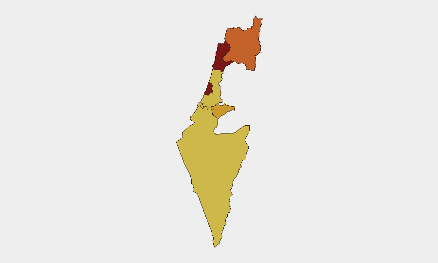
Tel Aviv District (96.5) and Haifa District (85.8) face the highest composite risk due to dense population, critical commercial and governmental infrastructure, and proximity to both operational zones and launch corridors for indirect fire from Gaza. North District (73.8) reflects ongoing potential for Hezbollah-related threats and border-area instability. Jerusalem District (71.2) carries sustained risk from internal political tension, property damage, and potential for rapid escalation around sensitive religious and administrative sites. South District (66.9) faces direct exposure to Gaza-originating strikes and ground-incursion risk.
How GeoBit Would Assist
Corporate security teams should leverage AOI Monitoring & Early Warning to establish persistent watch over Tel Aviv, Haifa, and South District perimeters for real-time alert on rocket-fire events and military activity. Conflict & Military capabilities (battle mapping, force-structure tracking) and GIS & Spatial Analysis enable route-planning around active combat zones and facilitate duty-of-care coordination for personnel near Khan Younis, northern Gaza, and southern Israel. Intel Sweep and multi-language OSINT (including Hebrew and Arabic feeds) provide 24-hour threat-signal corroboration, reducing latency between event occurrence and internal alert.
7-Day Outlook
Cross-border airstrike and ground-combat operations are expected to continue at current or elevated tempo through 2026-08-07, with no political or ceasefire indicators on the immediate horizon. Rocket-fire threat and reciprocal IDF suppression cycles will likely persist, maintaining heightened alert status for southern and central Israel. Risk of tactical escalation or third-party involvement (Iran, Hezbollah) remains elevated but not imminent based on current signal patterns.
Highest-Risk Areas — Ranked
| # | State / Region | Risk |
|---|---|---|
| 1 | Tel-Aviv District | 96.5 |
| 2 | Haifa District | 85.8 |
| 3 | North District | 73.8 |
| 4 | Jerusalem District | 71.2 |
| 5 | South District | 66.9 |
| 6 | Center District | 66.5 |
Sources
Previous Daily Briefs
A new Israel brief is written every day — each with its own risk map and downloadable CSV. Here's the last week; use the calendar to go further back.
📅 Browse every day by calendar →
Highlighted days have a brief. Tap a day for that day's map & analysis, or “csv” for that day's dataset ($5).
Atlas — our AI intelligence desk — emails them this snapshot personally. Nothing else, no list.