Situation Summary
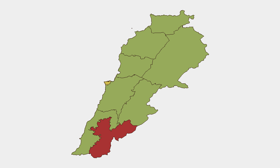
Lebanon remains under sustained operational pressure along its southern border, with Israeli forces conducting repeated bombardment and demolition campaigns across multiple villages in the Tyre and Bint Jbeil districts despite an announced June withdrawal framework. Nabatieh Governorate has emerged as the highest-risk sub-national zone (77.3), driven by concentrated cross-border military operations targeting suspected Hezbollah infrastructure, while Beirut itself remains elevated (67.3) amid political and diplomatic tensions. The security environment shows no signs of rapid de-escalation; instead, localized but persistent kinetic activity and infrastructure destruction are generating displacement risk and complicating civilian return and recovery efforts.
Key Developments
- Mansouri and Majdal Zoun (Tyre District) – 30 July 2026: Israeli forces conducted multiple bombardment waves within hours of each other, including demolition of buildings and renewed shelling, signaling sustained rather than episodic cross-border operations in the same target localities.
- Bint Jbeil area (between Beit Yahoun, Kounine, Baraachit) – 29 July 2026 overnight: Israeli airstrikes reported on villages between these settlements, with damage to civilian-adjacent infrastructure, maintaining attack tempo despite framework discussions.
- Ali al-Taher strategic hill (Nabatieh Governorate) – 29 July 2026 overnight: Israeli artillery shelling of high-ground positions allegedly containing Hezbollah tunnel networks, reflecting continued targeting of underground infrastructure north of the Yellow Line.
- Beaufort Castle vicinity (Marjayoun area, South Lebanon) – within 48 hours: Israeli military reported a large-scale tunnel destruction operation using approximately 700 tonnes of explosives against suspected Hezbollah underground network.
- Israeli-controlled "security zone," South Lebanon – 30 July 2026: Israeli military reported killing an armed militant within the zone it controls, indicating continued friction and armed presence in areas nominally subject to phased withdrawal.
- Yellow Line villages and UNIFIL areas – last 48 hours: Expanded UNIFIL patrols and engineering activity reported, including explosive device discovery and unexploded ordnance management, reflecting both stabilization efforts and ongoing hazard risk to returning civilians.
- Multi-village demolition campaign – ongoing into 30 July 2026: Property destruction operations confirmed across dozens of villages in Tyre and Bint Jbeil districts, complicating infrastructure recovery and civilian movement corridors.
Highest-Risk Areas
Nabatieh Governorate (77.3) dominates the risk landscape, driven by the concentration of Israeli cross-border military operations, tunnel targeting, and repeated bombardment cycles documented in the past 48 hours. Beirut Governorate (67.3) ranks second, reflecting political volatility and diplomatic friction with Turkey and Israel documented in recent statements and threats. The remaining governorates cluster at 47.3, indicating widespread but lower-intensity secondary risk; however, South Lebanon's villages along the Yellow Line remain operationally volatile despite this uniform sub-national score.
How GeoBit Would Assist
Security teams monitoring personnel or assets in Lebanon should employ persistent area-of-interest monitoring across Nabatieh and South Lebanon villages to detect escalation in bombardment patterns and demolition activity; pair this with Intel Sweep and multi-language OSINT fusion to correlate Israeli military statements, Lebanese media reports, and UNIFIL updates in real time. Satellite and imagery analysis of the Yellow Line and Beaufort Castle region would track infrastructure damage and reoccupation risk, while routing and network analysis would support alternative route planning for staff movement avoiding high-impact zones. Early warning and prediction capability should flag proximity to UNIFIL engineering activity and explosive device discovery zones.
7-Day Outlook
Israeli operations are likely to continue at current intensity through early August, with focus on tunnel destruction and border-village infrastructure demolition rather than major escalation. UNIFIL consolidation activity may create short-term movement friction and clearance delays. No major political breakthrough is expected to alter ground operations in this timeframe.
Highest-Risk Areas — Ranked
| # | State / Region | Risk |
|---|---|---|
| 1 | Nabatieh Governorate | 77.3 |
| 2 | Beirut Governorate | 67.3 |
| 3 | North Governorate | 47.3 |
| 4 | Akkar Governorate | 47.3 |
| 5 | Keserwan-Jbeil Governorate | 47.3 |
| 6 | Mount Lebanon Governorate | 47.3 |
| 7 | South Governorate | 47.3 |
| 8 | Beqaa Governorate | 47.3 |
| 9 | Baalbek-Hermel Governorate | 47.3 |
Sources
Previous Daily Briefs
A new Lebanon brief is written every day — each with its own risk map and downloadable CSV. Here's the last week; use the calendar to go further back.
📅 Browse every day by calendar →
Highlighted days have a brief. Tap a day for that day's map & analysis, or “csv” for that day's dataset ($5).
Atlas — our AI intelligence desk — emails them this snapshot personally. Nothing else, no list.