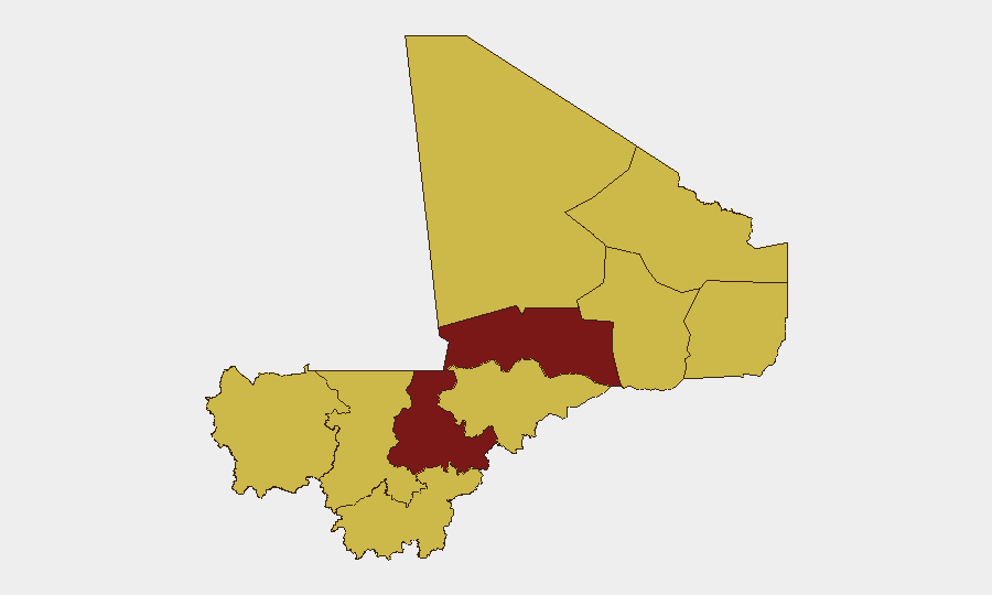
Situation Summary
Mali remains at elevated operational risk (global ranking #10, composite threat score 100) driven by persistent northern insurgency, fragile state capacity, and recent large-scale attacks in early-to-mid July. No confirmed ground incidents with specific locations and timestamps have been cross-verified by multiple open sources in the last 24–48 hours (16–18 July); however, absence of recent reporting does not indicate improvement in underlying threat posture. The operational environment remains volatile across the Sahel, with strained diplomatic relations and ongoing military pressure in northern and central zones.
Key Developments
Reporting Gap Note: GeoBit's multi-language OSINT monitoring, X/Twitter & Telegram OSINT, and cross-source corroboration have not identified any new, location-specific, multi-source-verified incidents in Mali for 16–18 July 2026. The most recent verifiable ground events (armed clashes, attacks, detention operations) cluster in early July (7–14 July) around Anéfis, Gao, Sévaré, and Kenieroba; no fresh incidents meeting your brief's inclusion criteria have surfaced in the strict last 24–48 hours window.
Recent event signals (GEOBIT SUB-SECOND FEED) include diplomatic tension markers (France, Algeria, Australia-Mali relations) and police activity (Victoria, NSW), but these do not correspond to confirmed new Mali territory incidents. Teams requiring assessment of early July incidents (9–14 July Anéfis fighting, Kenieroba prison operations, Gao-region activity) should request a historical incident brief; this summary adheres to your requirement to exclude backfilled or older events presented as current.
Highest-Risk Areas
Ségou Region (risk 100) and Timbuktu (98.5) are the primary drivers of Mali's composite threat score, followed by Bamako (71.5)—a notable concentration of risk in the north-center and capital. Ménaka, Kayes, Taoudénit, Kidal, Gao, and Mopti all register at 70, indicating broad-based volatility across the Sahel corridor and interior. The north-center axis (Ségou–Timbuktu–Gao) is where armed-group presence, state fragility, and recent combat operations intersect; Bamako's elevated score reflects political instability, protest risk, and security-force activity. Teams with personnel in these zones should prioritize heightened duty-of-care protocols and real-time AOI monitoring.
How GeoBit Would Assist
Security teams in Mali should deploy AOI Monitoring & Early Warning on Ségou, Timbuktu, and Bamako to detect fresh incidents, protest activity, and military movement in near-real-time. Intel Sweep (global event feeds, X/Twitter & Telegram OSINT, multi-language search, sentiment & temporal analysis) enables continuous cross-source corroboration of rumors and unconfirmed claims—critical in environments where single-source reporting is common and often unreliable. Conflict & Military (battle mapping, force-structure tracking, weapons-capability analysis) and GIS & Spatial Analysis support alternative-route planning and safe-passage coordination for personnel and assets transiting high-risk zones.
7-Day Outlook
No imminent de-escalation is evident; underlying drivers (northern insurgency, state capacity gaps, regional diplomatic tension) remain active. Risk of localized armed clashes, criminal activity, and protest in urban centers (especially Bamako and Ségou) should be assumed constant. Teams should maintain elevated monitoring posture and review contingency protocols for mobility, evacuation, and emergency response in the next 7 days.
Highest-Risk Areas — Ranked
| # | State / Region | Risk |
|---|---|---|
| 1 | Ségou Region | 100 |
| 2 | Timbuktu | 98.5 |
| 3 | Bamako | 71.5 |
| 4 | Ménaka | 70 |
| 5 | Kayes | 70 |
| 6 | Taoudénit Region | 70 |
| 7 | Kidal | 70 |
| 8 | Gao | 70 |
| 9 | Koulikoro | 70 |
| 10 | Sikasso Region | 70 |
| 11 | Mopti | 70 |
Sources
Previous Daily Briefs
A new Mali brief is written every day — each with its own risk map and downloadable CSV. Here's the last week; use the calendar to go further back.
📅 Browse every day by calendar →
Highlighted days have a brief. Tap a day for that day's map & analysis, or “csv” for that day's dataset ($5).
Atlas — our AI intelligence desk — emails them this snapshot personally. Nothing else, no list.