Situation Summary
Myanmar remains in active civil war with composite threat ranking of #10 globally, driven by sustained clashes between junta forces and multiple armed opposition groups across the country. Recent developments confirm intense localized conflict along the Myanmar–Thailand border and in northern and southern conflict zones, though real-time incident reporting remains fragmented due to limited open-source access. The underlying security picture is one of persistent violence, displacement, and instability rather than imminent nationwide escalation, but localized intensity poses direct risks to movement, supply chains, and civilian populations in high-threat regions.
Key Developments
- Myawaddy Township, Karen State–Thailand border (8–11 July): Myanmar military conducted sustained airstrikes using YAX-130 and Y-12 aircraft against KNLA positions near Min Let Pan village over three days, with munitions confirmed landing inside Thai territory in Mahawan subdistrict. Thai border command deployed forces and initiated UXO clearance operations on 11 July.
- Mae Sot district, Tak Province, Thailand (5 & 8–11 July): Stray mortar and machine-gun fire from Myawaddy clashes impacted Thai civilian homes on 5 July; border crossing restrictions remained in effect through 11 July due to ongoing fighting.
- Gwa Township, southern Rakhine State (8 July): Arakan Army reported Myanmar junta naval units fired approximately 87 heavy shells at residential areas, injuring six civilians including a five-year-old child, indicating sustained coastal conflict and civilian vulnerability.
- Mawhan village area, northern Myanmar–Kokang border (8 July): MNDAA (Kokang) troops forcibly dismantled a KIA security checkpoint, signaling escalated tension and potential armed confrontation risk between these groups in the Kachin/Kokang corridor.
- Mandalay–Myitkyina Highway (ongoing since 30 June, no resolution as of 8–9 July): Clashes between junta and revolutionary forces have left hundreds of vehicles stranded for over a week, causing severe supply-chain disruption and passenger hardship on this critical northern artery.
- Data gap warning (7–11 July): Specialist sources explicitly flag limited verified incident data for the last 24–48 hours, indicating reporting lag rather than reduced violence. Underlying conflict remains acute in Magway, Kachin, and Shan regions despite sparse near-real-time open-source confirmation.
Highest-Risk Areas
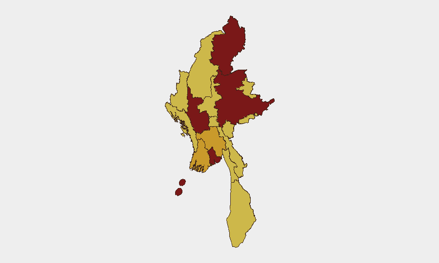
Magway Region (risk 100) and Shan State (91.8) rank highest and are primary drivers of the national threat score, followed closely by Kachin State (89.1). Yangon (80.9) registers elevated risk reflecting both urban security concerns and cumulative displacement effects. The sub-national pattern reflects active civil war concentrated in border and northern regions—Kachin, Shan, and Kokang areas show sustained inter-group clashes and checkpoint conflicts—while southern zones (Rakhine, Tanintharyi) and central regions face naval bombardment and localized fighting. Cross-border spillover into Thailand and ongoing supply-chain disruption on key highways underscore the operational impact of conflict geography.
How GeoBit Would Assist
Security teams operating in Myanmar should employ AOI Monitoring & Early Warning on high-risk states (Magway, Kachin, Shan) and the Myanmar–Thailand border corridor to detect clashes, airstrikes, or checkpoint activity in near-real time. Routing & Network Analysis capabilities enable identification of secure alternative supply routes around the Mandalay–Myitkyina blockade and border conflict zones. Conflict & Military battle mapping and force-structure tracking, combined with multi-language OSINT fusion from local and regional sources, close real-time reporting gaps and provide early signal of inter-group escalation (e.g., checkpoint removals, naval actions).
7-Day Outlook
Localized intensity along the Myanmar–Thailand border and in northern Kachin/Kokang zones is expected to remain elevated over the next week, with checkpoint clashes and potential airstrikes posing spillover risk to Thai territory. The Mandalay–Myitkyina highway blockade shows no near-term resolution; supply and personnel movement via this route should remain restricted. No major nationwide escalation is anticipated in open reporting, but fragmented data gaps mean significant incidents may occur without immediate verification.
Highest-Risk Areas — Ranked
| # | State / Region | Risk |
|---|---|---|
| 1 | Magway | 100 |
| 2 | Shan State | 91.8 |
| 3 | Kachin State | 89.1 |
| 4 | Yangon | 80.9 |
| 5 | Ayeyarwady | 72.7 |
| 6 | Bago Region | 72.7 |
| 7 | Tanintharyi Region | 70 |
| 8 | Chin | 70 |
| 9 | Sagaing Region | 70 |
| 10 | Wa State (Northern Region) | 70 |
| 11 | Mandalay | 70 |
| 12 | Rakhine | 70 |
Sources
Previous Daily Briefs
A new Myanmar brief is written every day — each with its own risk map and downloadable CSV. Here's the last week; use the calendar to go further back.
📅 Browse every day by calendar →
Highlighted days have a brief. Tap a day for that day's map & analysis, or “csv” for that day's dataset ($5).
Atlas — our AI intelligence desk — emails them this snapshot personally. Nothing else, no list.