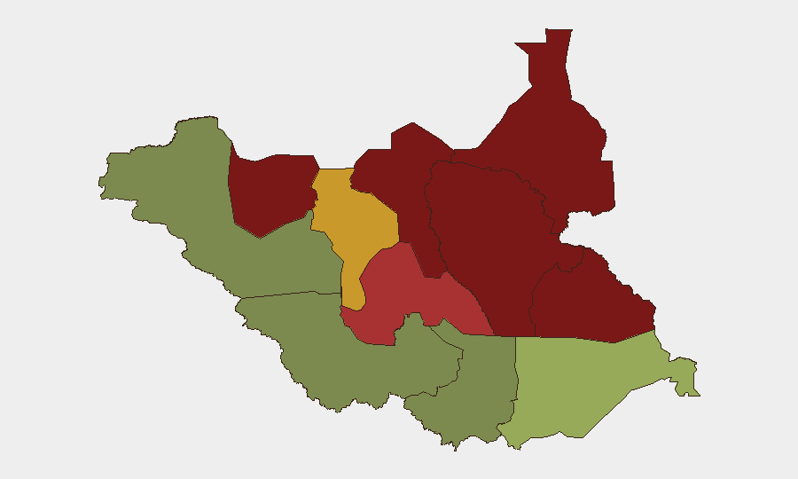
Situation Summary
South Sudan remains in active armed conflict with a composite threat score of 65 (rank #31 globally), driven primarily by organized communal and inter-group violence rather than state-level warfare. Recent days have seen coordinated armed assaults across northern and central regions, with cattle raiding and civilian targeting as primary tactics. The security environment shows no signs of de-escalation; Unity and Jonglei States remain flash points for mass-casualty incidents. Organizations with personnel or assets in-country face sustained risk of sudden, large-scale violence with limited warning.
Key Developments
- Unity State, cattle camps — 9 August 2026: Coordinated assault by armed youth killed 60+ civilians and wounded approximately 50; UNMISS documented the incident. Suggests organized mobilization and planning capability among non-state actors.
- Pan-Ariik and Akok Payam, Jonglei State — 6 August 2026: Synchronized two-location armed attacks resulted in 37 confirmed civilian deaths. Pattern indicates coordination across dispersed geographical areas.
- Unity State cattle camp — 10 August 2026: Overnight armed raid killed 12 civilians with additional unconfirmed serious injuries. Incident aligns with elevated operational tempo in Unity State.
- U.S. Ebola-related travel advisory — 12–14 August 2026: Entry restrictions extended to include persons recently present in South Sudan, reflecting epidemiological risk layered on existing security threats.
- No additional verified developments within last 24 hours: Current web research has not surfaced confirmed new incidents beyond the above timeframe in the past day.
Highest-Risk Areas
Unity (95), Jonglei (93), and Upper Nile (88) States dominate the threat landscape and are the primary drivers of national-level risk. All three are characterized by active armed-group presence, weak state authority, pastoralist-community tensions over cattle and grazing rights, and a track record of coordinated mass-casualty incidents. Greater Pibor Administrative Area (87) and Northern Bahr el Ghazal (82) follow as secondary hot spots. In contrast, Western Equatoria (38) and Western Bahr el Ghazal (28) present markedly lower composite risk, though security conditions remain fragile. Personnel and assets in the northern and central regions should be treated as operating in active conflict zones; duty-of-care protocols should reflect the realistic possibility of rapid deterioration and limited evacuation windows.
How GeoBit Would Assist
Security and risk teams would benefit from Area-of-Interest (AOI) Monitoring & Early Warning on Unity, Jonglei, and Upper Nile States to detect patterns in armed-group movement, cattle raiding, and displacement before mass-casualty incidents occur. Network & Actor Analysis can map relationships between armed groups and identify coordination signals on Telegram and other platforms. Conflict & Military battle mapping and GIS & Spatial Analysis enable real-time plotting of incident locations, attack vectors, and safe-movement corridors. Combined with OSINT fusion and multi-language Telegram/X intelligence collection, these tools support faster threat escalation and informed evacuation decisions.
7-Day Outlook
Armed-group activity is expected to sustain or increase as dry-season cattle migration intensifies competition for grazing and water access. The coordinated nature of recent attacks (9–10 August) suggests sustained organizational capacity among non-state actors. Without major diplomatic intervention or security-force deployment, the northern regions will remain at acute risk for further civilian casualties and displacement.
Highest-Risk Areas — Ranked
| # | State / Region | Risk |
|---|---|---|
| 1 | Unity | 95 |
| 2 | Jonglei | 93 |
| 3 | Upper Nile | 88 |
| 4 | Greater Pibor Administrative Area | 87 |
| 5 | Northern Bahr el Ghazal | 82 |
| 6 | Lakes | 78 |
| 7 | Warrap | 72 |
| 8 | Ruweng Administrative Area | 68 |
| 9 | Eastern Equatoria | 52 |
| 10 | Western Equatoria | 38 |
| 11 | Central Equatoria | 35 |
| 12 | Western Bahr el Ghazal State | 28 |
Sources
Previous Daily Briefs
A new South Sudan brief is written every day — each with its own risk map and downloadable CSV. Here's the last week; use the calendar to go further back.
- August 14, 2026
- August 12, 2026
- August 11, 2026
- August 10, 2026
- August 9, 2026
- August 7, 2026
- August 6, 2026
📅 Browse every day by calendar →
Highlighted days have a brief. Tap a day for that day's map & analysis, or “csv” for that day's dataset ($5).
Atlas — our AI intelligence desk — emails them this snapshot personally. Nothing else, no list.