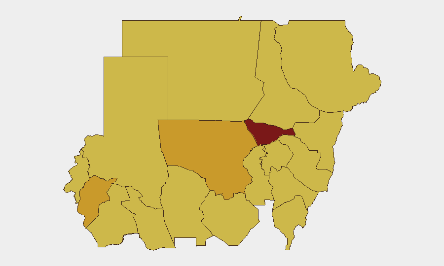
Situation Summary
Sudan remains the world's fifth-highest-threat environment, driven by an ongoing civil war between the Sudanese Armed Forces (SAF) and the Rapid Support Forces (RSF) that has fractured state control across most regions. The past 48 hours have seen a sharp escalation in aerial strikes on civilian concentrations—including markets, IDP gatherings, and border towns—combined with significant RSF defections and a UN Security Council warning of imminent mass atrocities in North Kordofan. The conflict is expanding geographically into previously less-affected areas while international isolation of the SAF deepens, creating unpredictable shifts in both tactical dynamics and humanitarian access.
Key Developments
- Tina (Sudan–Chad border, North Darfur) — 25 July 2026. Drone strikes killed at least 21 people in the twin border town; a second strike crossed into Chad. Cross-border escalation and high civilian casualty toll signal potential for regional spillover.
- Southern Badia, Blue Nile State — 23 July 2026. SAF drone strike on a displaced-persons gathering killed and injured dozens, predominantly women and children, according to Emergency Lawyers. Indicates continued targeting of civilian IDP concentrations.
- Ar Rahad market, North Kordofan State — 24 July 2026. Drone attack killed at least 6 people including children aged 6–14, injured 20+ overall. Part of a broader wave of aerial strikes across Kordofan and Blue Nile this week.
- Saq al-Jamal, West Kordofan State — 24 July 2026. RSF small-arms fire on a civilian vehicle killed a six-year-old child and seriously injured his brother. Illustrates ongoing armed-group violence on rural roads outside major conflict zones.
- RSF defections (Omdurman and El-Obeid) — 22 July 2026. Over 300 RSF fighters surrendered across two fronts (280+ in Darfur/Omdurman, 44 in West Kordofan). Indicates internal RSF fracturing but does not reduce overall conflict intensity.
- El-Obeid, North Kordofan — UN Security Council statement, 25 July 2026. Council demanded RSF halt its assault on the city and warned of "imminent risk of mass atrocities" as RSF masses reinforcements. Reflects expectation of major urban offensive with high civilian-harm potential.
- US sanctions on Sudan — 20 July 2026. State Department imposed new sanctions citing chemical-weapons use, further constraining SAF financing and diplomatic options; may influence conflict trajectory and humanitarian operations access.
Highest-Risk Areas
Al Khartum (risk 97.9) remains the epicenter due to its status as the seat of government and primary urban battleground; North Kordofan, Central and North Darfur, and the Red Sea/Kassala corridor follow at 68–73 risk scores. The current 48-hour pattern shows acute threat migration toward North Kordofan (particularly El-Obeid and Ar Rahad) and Blue Nile, where drone strikes and RSF operational activity are concentrated. Border regions—especially North Darfur and West Kordofan—face compounded risk from cross-border spillover and RSF/SAF operational volatility on roads.
How GeoBit Would Assist
Organizations with personnel or assets in Sudan should employ GeoBit's AOI Monitoring & Early Warning capability to track real-time activity in El-Obeid, Ar Rahad, Blue Nile corridors, and border zones, with alerting thresholds set for drone activity, armed-group movement, and IDP congregation. Battle Mapping and Force Structure tracking would clarify RSF and SAF positions ahead of the anticipated El-Obeid assault, enabling route-planning and safe-haven decisions. Routing & Network Analysis should be applied to all ground movement to identify secondary roads and cross-border alternatives where small-arms and checkpoint risk is lower.
7-Day Outlook
El-Obeid is likely to experience a major RSF assault within days, with significant risk of urban warfare and mass-casualty events. Drone strikes on civilian targets across Blue Nile and Kordofan will probably continue as the SAF escalates aerial operations. Organizations should expect further defections and tactical realignment but not de-escalation; humanitarian access will remain severely constrained across North Kordofan and Darfur.
Highest-Risk Areas — Ranked
| # | State / Region | Risk |
|---|---|---|
| 1 | Al Khartum | 97.9 |
| 2 | North Kordofan State | 72.9 |
| 3 | Central Darfur State | 71.2 |
| 4 | North Darfur State | 70.4 |
| 5 | River Nile State | 68.7 |
| 6 | Red Sea State | 68.7 |
| 7 | Kassala State | 68.7 |
| 8 | Blue Nile | 67.9 |
| 9 | Aj Jazira | 67.9 |
| 10 | Al Qadarif State | 67.9 |
| 11 | Sennar State | 67.9 |
| 12 | South Darfur State | 67.9 |
Sources
Previous Daily Briefs
A new Sudan brief is written every day — each with its own risk map and downloadable CSV. Here's the last week; use the calendar to go further back.
📅 Browse every day by calendar →
Highlighted days have a brief. Tap a day for that day's map & analysis, or “csv” for that day's dataset ($5).
Atlas — our AI intelligence desk — emails them this snapshot personally. Nothing else, no list.