Situation Summary
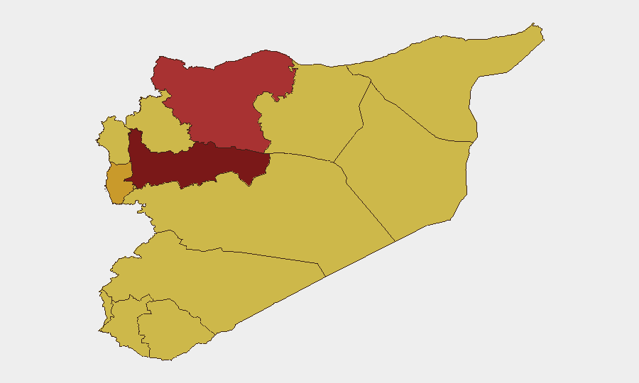
Syria remains a high-risk operating environment (composite threat score 96, rank #14 globally) with 219 tracked events in the assessment window. Recent activity signals a volatile security posture characterized by conventional military operations, law-enforcement detentions, cross-border incidents, and asymmetric attacks. Hama Governorate presents the most acute sub-national risk (97.4), followed by Aleppo and Damascus, indicating sustained instability across northern, central, and capital regions.
Key Developments
- Damascus café bombing (mid-July, exact date not independently confirmed): An explosion in central Damascus killed 9–10 civilians and wounded 20; one attacker was killed, one injured, and one detained. This represents a significant security incident in the capital affecting civilian areas.
- ISIS lethal attack, Eastern Syria (date not independently confirmed): Islamic State claimed responsibility for an attack killing two Syrian army soldiers, reported as the group's first confirmed lethal strike on Syrian government forces since February 2026.
- Uzbek fighter detention, Northwestern Syria (date not independently confirmed): Syrian security forces detained Uzbek fighters during an operation following a dispute and protests outside a government facility, indicating internal security management challenges.
- Israeli military incursion, Al-Rafid/Quneitra (date not independently confirmed): Syrian state media reported an Israeli military bulldozer entered Al-Rafid village in Quneitra countryside, consistent with ongoing border-zone friction.
- Israeli gunfire on civilians, Ma'riya (Southern Syria, date not independently confirmed): Israeli forces reportedly fired machine guns at civilian homes in Ma'riya near the Dar'a/Golan disengagement line.
- US–Iran disapproval signal (2026-07-15): Tracked disapproval event between United States and Iran entities, suggesting renewed diplomatic or strategic tension with potential spillover effects in Syria.
- Military public statements and law-enforcement disapproval (2026-07-18): Military entities issued public statements while law-enforcement authorities registered disapproval signals, indicative of ongoing internal coordination challenges or public messaging around security operations.
Highest-Risk Areas
Hama Governorate (97.4) is the single highest-risk sub-national zone and warrants priority monitoring for any corporate or personnel operations. Aleppo (76.1) and Damascus (73.1) follow closely, with Damascus particularly sensitive given its role as the capital and the recent café bombing. The coastal and southern periphery—Tartus, Lattakia, and the UNDOF zone—present elevated but secondary risk (67.4–72.8), driven by border dynamics, foreign military presence, and irregular armed group activity. Northern and eastern zones (Idleb, Ar-Raqqa, Al-Hasaka) reflect ongoing ISIS operational capability and Turkish-backed militia presence.
How GeoBit Would Assist
Intel Sweep and OSINT Fusion would enable real-time corroboration of incident reports and actor identification across conflict events, while AOI Monitoring & Early Warning with persistent area-of-interest watches would provide automated alerting for Damascus, Hama, and other high-risk governorates. Network & Actor Analysis would track detention patterns, militant group signaling, and law-enforcement coordination to detect emerging internal or external pressure. Battle Mapping and Force Structure tracking would monitor military deployments and cross-border movements, particularly along the Israeli and Turkish boundaries, to anticipate civilian risk escalation.
7-Day Outlook
Near-term risk is likely to remain elevated, with ongoing low-intensity conflict, sporadic asymmetric attacks, and border incursions as baseline conditions. Any further ISIS claims or Israeli–Syrian military friction could drive localized escalation, particularly in Dar'a, Quneitra, and Eastern Hasaka. Corporate teams should maintain heightened duty-of-care protocols for Damascus and northern operations and ensure real-time alert subscriptions to monitor shifts in the threat picture.
Highest-Risk Areas — Ranked
| # | State / Region | Risk |
|---|---|---|
| 1 | Hama Governorate | 97.4 |
| 2 | Aleppo Governorate | 76.1 |
| 3 | Damascus Governorate | 73.1 |
| 4 | Tartus Governorate | 72.8 |
| 5 | Al-Hasaka Governorate | 70.1 |
| 6 | Rif Dimashq Governorate | 68.3 |
| 7 | Lattakia Governorate | 67.4 |
| 8 | UNDOF | 67.4 |
| 9 | Al-Quneitra Governorate | 67.4 |
| 10 | Dar'a Governorate | 67.4 |
| 11 | Idleb Governorate | 67.4 |
| 12 | Ar-Raqqa Governorate | 67.4 |
Sources
Previous Daily Briefs
A new Syria brief is written every day — each with its own risk map and downloadable CSV. Here's the last week; use the calendar to go further back.
📅 Browse every day by calendar →
Highlighted days have a brief. Tap a day for that day's map & analysis, or “csv” for that day's dataset ($5).
Atlas — our AI intelligence desk — emails them this snapshot personally. Nothing else, no list.