Situation Summary
Eritrea remains at low global risk (#81 globally, composite score 24) with no confirmed security incidents recorded in the past week. Border tensions with Ethiopia persist, centered on disputed territory near Gundet and allegations of military movement that neither Asmara nor Addis Ababa has independently verified. Diplomatic rhetoric has intensified—Eritrea's UN ambassador and Foreign Ministry issued denials of incursion claims on 21 October—but no discrete security events within Eritrean territory have been documented in the current reporting window. Risk concentration remains heavily weighted to the western and southern border regions.
Key Developments
- 21 October, Gundet–Rama border sector: Conflict monitors reported that Eritrean forces were conducting trench-digging operations north of Rama following reported Ethiopian federal withdrawal from Zalambessa. Claim remains unverified by independent sources.
- 21 October, Asmara: Eritrea's Foreign Ministry categorically denied that its forces had crossed into Ethiopia and stated that all Eritrean military units remained within internationally recognized borders. Statement characterized Ethiopian allegations as fabricated.
- 21 October, New York (UN channel): Eritrean UN Ambassador Sophia Tesfamariam told US diplomats that no "crisis" existed between Eritrea and Ethiopia, while accusing Addis Ababa of threatening Eritrean sovereignty and territorial integrity. Messaging indicated Asmara's intention to frame the situation as Ethiopia-driven escalation.
- 25 October, Asmara (political messaging): Information Minister Yemane Gebremeskel posted criticism of Ethiopian officials' remarks on Red Sea security; the statement was political messaging rather than an operational security incident.
- Ongoing concern (pre-dating window, cited as context): Reports from 22–23 October referenced persisting fears of wider Ethiopia–Eritrea conflict following October allegations (outside this seven-day window) that Eritrean troops had entered areas around Adigrat and Idaga Hamus in the Tigray–Eritrea border region. No new corroboration emerged during 21–27 October.
Highest-Risk Areas
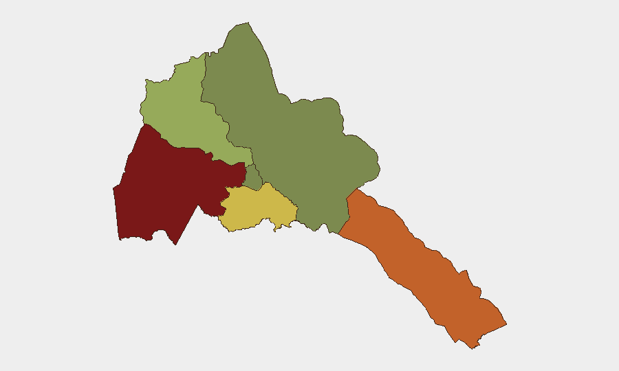
Gash-Barka (risk score 92) and the Southern Red Sea Region (75) drive nearly all recorded sub-national risk, reflecting their proximity to the Ethiopia–Eritrea border and the disputed Badme sector. Debub Region (68) also reflects cross-border tension exposure. These three western and southern zones account for the overwhelming majority of Eritrea's internal risk gradient; Maekel Region (Asmara and central areas, score 18) remains substantially lower-risk, and the Northern Red Sea Region registers minimal current concern. The risk concentration is fundamentally border-driven rather than internal to Eritrean stability.
How GeoBit Would Assist
Organizations with personnel or assets in Eritrea should employ GeoBit's AOI Monitoring & Early Warning on Gash-Barka and Southern Red Sea border sectors to detect military repositioning or incursion alerts with minimal latency. Conflict & Military capabilities—including force-structure tracking and battle mapping—would allow security teams to distinguish rumor from verified movement along the Gundet–Rama and Tigray corridors. OSINT fusion & corroboration across social media, local radio, and regional conflict monitors would help validate or dismiss unverified border claims before they escalate internal response.
7-Day Outlook
Border rhetoric and military posturing are likely to continue as part of ongoing Ethiopia–Eritrea diplomatic friction, but no imminent military escalation inside Eritrea is indicated by current reporting. Risk remains concentrated in western border zones; personnel and assets in Asmara and central Maekel Region face minimal elevated threat from the current dynamic. Monitoring should remain active on Gash-Barka and Southern Red Sea developments, particularly any claims of force movement, to detect early warning of operational changes.
Highest-Risk Areas — Ranked
| # | State / Region | Risk |
|---|---|---|
| 1 | Gash-Barka | 92 |
| 2 | Southern Red Sea Region | 75 |
| 3 | Debub Region | 68 |
| 4 | Anseba | 55 |
| 5 | Maekel Region | 18 |
| 6 | Northen Red Sea Region | 0 |
Sources
Previous Weekly Briefs
A new Eritrea brief is written every Monday, covering the week — each with its own risk map and downloadable CSV. Use the calendar to go further back.
- October 20, 2026
- October 13, 2026
- October 6, 2026
- September 29, 2026
- September 22, 2026
- September 15, 2026
- September 8, 2026
📅 Browse past briefs by calendar →
Highlighted days have a brief. Tap a day for that day's map & analysis, or “csv” for that day's dataset ($5).
Atlas — our AI intelligence desk — emails them this snapshot personally. Nothing else, no list.