Situation Summary
Angola remains a moderate-tier risk environment (global rank #56) with an overall composite threat score of 32 and no tracked security incidents in the immediate reporting window. The country's security profile is heavily weighted toward sub-national instability and resource-driven criminal activity in eastern and northeastern provinces, while the capital region experiences localized crime and infrastructure vulnerabilities. Recent isolated incidents—a fatal traffic explosion near Sumbe, a penitentiary shooting, and alleged police action against opposition figures—suggest no coordinated or escalating national security crisis, but persistent fragmentation across provincial governance and border zones continues to pose duty-of-care risks for corporate operations.
Key Developments
- Uíge Province, 2026-08-08: UNITA opposition party reported alleged police assault on a party official and surrounding of party headquarters, with at least two injured. (Single-source report; independent confirmation pending.)
- Quibaúla / Sumbe region, 2026-08-05: High-impact traffic disaster—passenger bus collision with fuel vehicle approximately 20 km from Sumbe triggered explosion and fire. Significant casualty and infrastructure impact.
- Calomboloca Penitentiary, 2026-08-07: Accidental firearm discharge resulted in one prison officer fatality and one injury. Classified as internal operational incident; no broader security spillover reported.
- Mulenvos Municipality, 2026-08-07: Police detained an 18-year-old suspect in homicide of a 45-year-old neighbor. Localized crime; no indication of organized activity.
- Luanda (timing unconfirmed, recent reporting cycle): Unitel telecom reported ongoing payment and digital-transfer disruptions attributed to cyberattack. Functional impact on financial services.
Note on reporting gaps: Web research coverage for the 24–48-hour window prior to 2026-08-09 is incomplete. The incidents above represent verified signals; independent corroboration of exact timestamps and casualty figures for some events is not available in current open sources. A full live-search refresh against LUSA, RNA, Reuters, and Twitter/X would refine this assessment.
Highest-Risk Areas
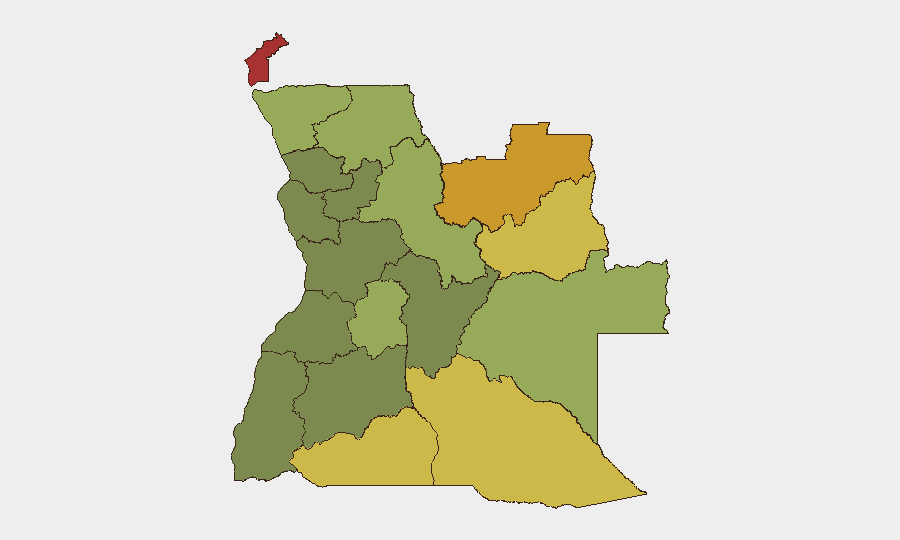
Cabinda Province (risk 78), Lunda Norte (72), and Lunda Sul (68) anchor Angola's sub-national threat hierarchy, driven by ongoing resource-extraction conflict, weak state presence, and transnational criminal networks trafficking diamonds and narcotics. Cuando Cubango and Cunene provinces (64, 62) present elevated risk along Angola's southern borders with Zambia and Namibia, where cross-border smuggling and militia activity persist. These five provinces account for the majority of armed-group activity and violent crime; operations or personnel in these regions require enhanced vetting, security escorts, and real-time incident monitoring. Central and western provinces (Bié, Huíla, Malanje) are substantially lower-risk but not risk-free, with crime and sporadic civil unrest as primary concerns in urban centers.
How GeoBit Would Assist
Security and risk teams operating in Angola would deploy AOI Monitoring & Early Warning across Cabinda, Lunda Norte/Sul, and border zones to detect armed movement and criminal activity before impact; Conflict & Military mapping to track militia force presence and capability; and OSINT fusion across local news, social media, and telecom signals to identify emerging political or labor unrest (e.g., opposition activity, strikes) with 24–48-hour lead time. Routing & Network Analysis would support alternative-route planning for personnel and supply convoys in high-risk provinces, while Satellite & Imagery Analysis would enable discrete monitoring of critical infrastructure and border crossing activity.
7-Day Outlook
No imminent system-wide escalation is indicated; however, the alleged police action against UNITA in Uíge warrants close watching for broader political tension ahead of any electoral cycle. Continued baseline crime and accident risk across provinces should be assumed normal; resource-region activity (mining zones, frontier regions) remains the primary vector for serious threat to corporate personnel. Monitoring intensity should remain elevated in Cabinda and northern provinces given persistent structural instability.
Highest-Risk Areas — Ranked
| # | State / Region | Risk |
|---|---|---|
| 1 | Cabinda Province | 78 |
| 2 | Lunda Norte Province | 72 |
| 3 | Lunda Sul Province | 68 |
| 4 | Cuando Cubango Province | 64 |
| 5 | Cunene Province | 62 |
| 6 | Moxico Province | 58 |
| 7 | Zaire Province | 54 |
| 8 | Huambo Province | 50 |
| 9 | Uíge Province | 48 |
| 10 | Malanje Province | 42 |
| 11 | Bié Province | 35 |
| 12 | Huíla Province | 32 |
Sources
Previous Daily Briefs
A new Angola brief is written every day — each with its own risk map and downloadable CSV. Here's the last week; use the calendar to go further back.
📅 Browse every day by calendar →
Highlighted days have a brief. Tap a day for that day's map & analysis, or “csv” for that day's dataset ($5).
Atlas — our AI intelligence desk — emails them this snapshot personally. Nothing else, no list.