Situation Summary
Central African Republic remains at elevated baseline risk (composite threat score 67, ranked #27 globally) driven by persistent armed-group activity, cross-border incursions, and abuses by state-aligned forces across northeastern and southeastern prefectures. No clearly documented new security incidents meeting verification and time-stamp criteria have emerged in the last 24–48 hours; the most recent confirmed events are from late June and early July 2026. Current conditions reflect ongoing patterns of instability rather than an acute escalation, though risk remains concentrated in remote frontier regions with limited state presence and humanitarian access.
Key Developments
No new, multi-source-verified security incidents with precise date-stamps in the last 24–48 hours are available from open-source reporting. The most recent dated event in trackers is a July 2, 2026 armed-group attack in Am Dafok (Vakaga prefecture, northeastern CAR), followed by July 6 MINUSCA security response—both outside the immediate 24–48-hour window but indicative of ongoing northeastern threat activity. A July 18, 2026 visit by Prime Minister Félix Moloua to Birao (Vakaga) was a political reassurance mission following the June 30 Am Dafock attack and displacement of thousands; it did not report new incidents. Baseline conditions in Vakaga, Haut-Mbomou, and surrounding prefectures remain characterized by armed-group presence, inter-communal tension, and limited MINUSCA coverage. Data gaps reflect both genuine operational quiet in the last 48 hours and recurring challenges in real-time reporting from remote border areas.
Highest-Risk Areas
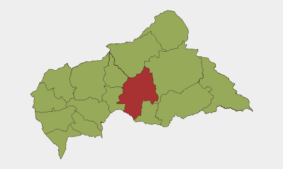
Ouaka prefecture (risk score 77) is the single highest-risk state, significantly outpacing others. The northeastern and southeastern frontier zones—Vakaga, Haut-Mbomou, Haute-Kotto, and Mbomou—collectively score 47 each and represent the country's primary armed-group strongholds, cross-border smuggling corridors, and displacement hotspots. These areas experience recurrent incursions from Sudan-based groups, Chadian militia activity, and fragmented Central African armed organizations. Ouham-Pendé, Nana-Mambéré, and Mambéré-Kadéï (western prefectures) maintain elevated risk despite lower scores, reflecting banditry and occasional inter-group clashes. Western and central zones remain relatively more stable but are not secure.
How GeoBit Would Assist
Corporate and duty-of-care teams operating in or transiting CAR should leverage Intel Sweep and global event feeds for near-real-time incident alerting, supplemented by multi-language OSINT (X/Telegram/local radio SIGINT) to capture armed-group communications and civilian reporting missed by English-language trackers. Area-of-interest monitoring and early-warning alerting on Ouaka, Vakaga, and Haut-Mbomou would enable persistent watch on high-risk prefectures without manual daily briefing overhead. GIS and spatial analysis combined with satellite/imagery review can identify displacement camps, armed-group concentrations, and route interdiction points to inform security routing and movement planning for personnel and assets.
7-Day Outlook
Short-term trajectory remains stable at elevated baseline; no indicators suggest imminent major escalation or major new armed-group offensive activity. Humanitarian access to northeastern prefectures will likely remain constrained, and sporadic armed-group activity (raiding, abductions, inter-group clashes) should be expected to continue at current tempo. Risk of secondary displacement and localized community tension in Vakaga and Haut-Mbomou will persist pending improved MINUSCA presence and cross-border security cooperation with Sudan.
Highest-Risk Areas — Ranked
| # | State / Region | Risk |
|---|---|---|
| 1 | Ouaka | 77 |
| 2 | Bamingui-Bangoran | 47 |
| 3 | Vakaga | 47 |
| 4 | Haute-Kotto | 47 |
| 5 | Haut-Mbomou | 47 |
| 6 | Mbomou | 47 |
| 7 | Nana-Mambéré | 47 |
| 8 | Ouham-Pendé | 47 |
| 9 | Mambéré-Kadéï | 47 |
| 10 | Sangha-Mbaéré | 47 |
| 11 | Ouham | 47 |
| 12 | Nana-Grébizi | 47 |
Sources
Previous Daily Briefs
A new Central African Republic brief is written every day — each with its own risk map and downloadable CSV. Here's the last week; use the calendar to go further back.
📅 Browse every day by calendar →
Highlighted days have a brief. Tap a day for that day's map & analysis, or “csv” for that day's dataset ($5).
Atlas — our AI intelligence desk — emails them this snapshot personally. Nothing else, no list.