Situation Summary
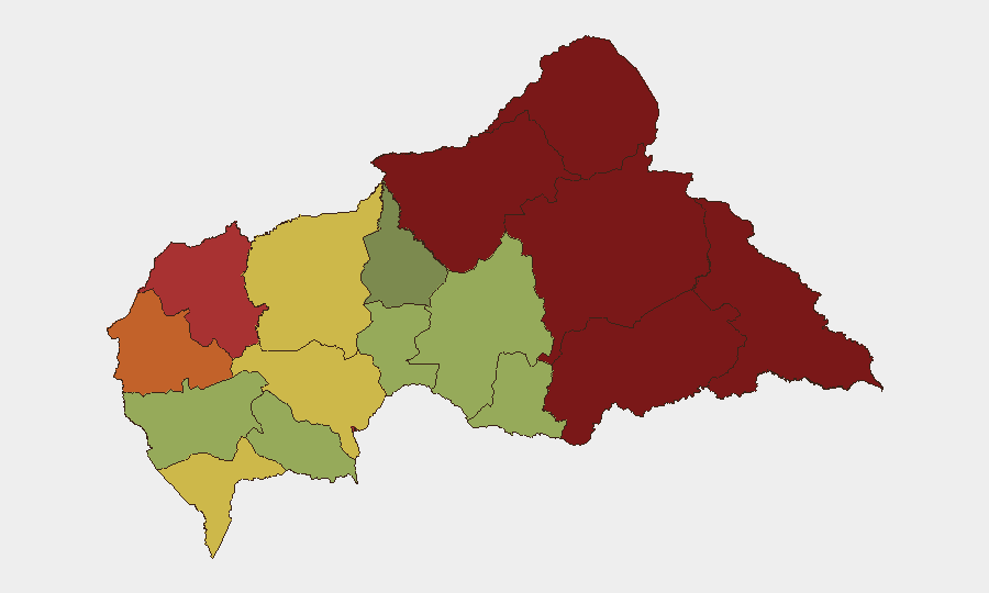
Central African Republic remains classified as a high-risk operating environment (composite threat score 66, ranked #32 globally) with persistent security challenges driven by armed-group activity, banditry, and disease outbreaks. No discrete security incidents have been confirmed in open sources within the last 24–48 hours; however, the absence of reported events reflects known monitoring gaps in the region rather than genuine stabilization. Underlying risk remains elevated, particularly in the northern and eastern prefectures where humanitarian access and civilian movement are severely constrained. The security posture is stable but fragile, with vulnerability to rapid escalation.
Key Developments
No multi-source-verified security incidents with specific dates falling within July 20–22, 2026, have been identified in available open-source feeds, social media, or regional news outlets. Recent reporting (mid-July) documented banditry and armed confrontations in Boali and along the PK45 corridor west of Bangui, but these events predate the current 24–48-hour window and should not be treated as active developments. Cholera and Ebola outbreaks continue to impede humanitarian operations and population movement across the country, as acknowledged by CAR's humanitarian minister on July 14, 2026, but no new health-sector incidents have been timestamped in the last two days. Open-source intelligence collection gaps in CAR remain significant; absence of reported incidents should be interpreted as incomplete visibility rather than confirmation of security improvement.
Highest-Risk Areas
Vakaga (risk 95), Bamingui-Bangoran (92), and Haute-Kotto (88) dominate the threat landscape, all located in the remote north and northeast where state presence is minimal and armed groups operate with limited opposition. These prefectures have historically served as sanctuaries for transnational militias and bandit networks; recent mid-July reporting also flagged Boali (within Ombella-M'Poko and Nana-Mambéré) as a site of violent activity. Bangui itself (risk 78) remains a secondary concern, reflecting urban crime, inter-communal tension, and the concentration of internally displaced persons; however, risk is substantially lower than in frontier zones. The 1,200+ km border with Chad and the DR Congo continues to facilitate cross-border militia movement and weapons smuggling, sustaining insecurity across the northern and eastern tier.
How GeoBit Would Assist
Corporate security and duty-of-care teams operating in CAR should employ AOI Monitoring & Early Warning on high-risk prefectures (Vakaga, Bamingui-Bangoran, Haute-Kotto) to detect emerging incidents before they impact operations or personnel movement. OSINT fusion (X/Twitter, Telegram, multi-language regional news aggregation, and entity extraction) combined with temporal analysis can disambiguate genuinely recent incidents from older events circulating in open sources—critical given the current data gaps. For personnel safety and logistics, Routing & Network Analysis should identify alternate transit corridors around known conflict zones and bandit activity nodes, updated daily against fresh field intelligence and open-source feeds.
7-Day Outlook
No major escalations are predicted in the immediate term based on current trend data, but the information gap itself poses operational risk; small incidents in remote areas may go unreported for days. Teams should assume baseline elevated risk and maintain heightened alertness in all northern and eastern zones. Disease outbreaks are likely to persist as a constraint on movement and humanitarian access, independently of security developments.
Highest-Risk Areas — Ranked
| # | State / Region | Risk |
|---|---|---|
| 1 | Vakaga | 95 |
| 2 | Bamingui-Bangoran | 92 |
| 3 | Haute-Kotto | 88 |
| 4 | Haut-Mbomou | 85 |
| 5 | Mbomou | 82 |
| 6 | Ouham-Pendé | 79 |
| 7 | Bangui | 78 |
| 8 | Nana-Mambéré | 75 |
| 9 | Sangha-Mbaéré | 68 |
| 10 | Ouham | 65 |
| 11 | Ombella-M'Poko | 62 |
| 12 | Kémo | 58 |
Sources
Previous Daily Briefs
A new Central African Republic brief is written every day — each with its own risk map and downloadable CSV. Here's the last week; use the calendar to go further back.
📅 Browse every day by calendar →
Highlighted days have a brief. Tap a day for that day's map & analysis, or “csv” for that day's dataset ($5).
Atlas — our AI intelligence desk — emails them this snapshot personally. Nothing else, no list.