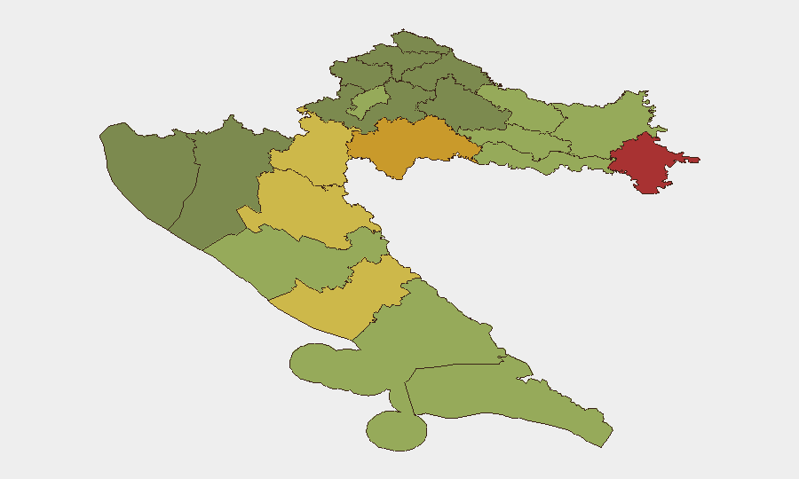
Situation Summary
Croatia remains a low-threat environment globally (rank #154, composite score 7) with no documented security incidents in the last 24–48 hours. Sub-national risk concentration is confined to the war-affected northeast and south-central regions; capital and coastal tourist zones carry substantially lower threat profiles. Wildfire season continues in southern coastal areas, though no specific new incidents have been confirmed within the reporting window.
Key Developments
- No major security, civil unrest, or infrastructure incidents confirmed within 2026-09-02–03. Available web intelligence, police-adjacent sources, and local media do not surface clearly dated events meeting recency and corroboration standards for the last 24–48 hours.
- Wildfire season remains active in Dubrovnik-Neretva County. General seasonal reporting indicates elevated risk in southern islands and hinterland through September; specific new fire starts or evacuations on 2026-09-02–03 have not been independently confirmed, though prior Facebook posts reference ongoing activity near Omiš and evacuations (dated earlier in late August).
- Planned civil-unrest activity: anti-waste protest scheduled for Zagreb, 5 September 2026. Balkan Green Energy News reports a mass demonstration over illegal waste disposal in Gospić; event has not yet occurred and no related security incidents have been documented to date.
- No travel warnings or advisories issued on 2026-09-02–03. No new diplomatic, police, or international risk guidance targeting Croatia has been published in the current window.
Highest-Risk Areas
Vukovar-Srijem, Sisak-Moslavina, Karlovac, and Lika-Senj counties dominate the risk ranking (scores 78, 72, 68, 65), all located in the eastern and south-central war-affected regions. These areas retain residual landmine and unexploded ordnance (UXO) hazards, sporadic inter-ethnic tensions, and lower economic capacity—factors that compound vulnerability to organized crime, human trafficking, and localized unrest. By contrast, Zagreb, Split-Dalmatia, and Zadar counties show materially lower composite scores (50, 48, 55), reflecting their urban density, international connectivity, and security infrastructure. Southern coastal counties carry moderate wildfire and seasonal tourism-surge risk but remain stable politically.
How GeoBit Would Assist
Corporate teams with personnel or assets in high-risk northeastern counties should deploy AOI Monitoring & Early Warning on Vukovar-Srijem and Sisak-Moslavina to catch emerging trafficking, organized-crime, or UXO incidents in near-real time. Multi-language OSINT and sentiment analysis (via social-media and local-news feeds) would provide 24–48 hour advance notice of planned protests or civil unrest in Zagreb and secondary cities. For operations in southern coastal areas, Environmental & Health data integration can flag wildfire risk escalation and evacuation zones, enabling route replanning via the platform's Routing & Network Analysis function before travel or supply-chain disruption occurs.
7-Day Outlook
No material escalation in national-level security risk is anticipated over the next seven days. The scheduled 5 September Zagreb protest carries low-to-moderate risk of localized disruption but no indication of violent unrest or broader instability. Wildfire conditions in Dubrovnik-Neretva County are expected to persist through mid-September given seasonal patterns; teams with south-coastal operations should maintain awareness of air-quality and evacuation-corridor developments.
Highest-Risk Areas — Ranked
| # | State / Region | Risk |
|---|---|---|
| 1 | Vukovar-Srijem County | 78 |
| 2 | Sisak-Moslavina County | 72 |
| 3 | Karlovac County | 68 |
| 4 | Lika-Senj County | 65 |
| 5 | Šibenik-Knin County | 62 |
| 6 | Brod-Posavina County | 58 |
| 7 | Zadar County | 55 |
| 8 | Osijek-Baranja County | 52 |
| 9 | City of Zagreb | 50 |
| 10 | Split-Dalmatia County | 48 |
| 11 | Požega-Slavonia County | 45 |
| 12 | Virovitica-Podravina County | 42 |
Sources
Previous Daily Briefs
A new Croatia brief is written every day — each with its own risk map and downloadable CSV. Here's the last week; use the calendar to go further back.
- August 31, 2026
- August 28, 2026
- August 26, 2026
- August 24, 2026
- August 22, 2026
- August 20, 2026
- August 18, 2026
📅 Browse every day by calendar →
Highlighted days have a brief. Tap a day for that day's map & analysis, or “csv” for that day's dataset ($5).
Atlas — our AI intelligence desk — emails them this snapshot personally. Nothing else, no list.