Situation Summary
Iran faces an acute and escalating security crisis driven by active U.S. military strikes across southern provinces, with at least 90 confirmed targets hit overnight July 11–12 and 14+ confirmed civilian and military deaths over the past 48 hours. The strikes target missile, drone, and maritime infrastructure linked to regional threats, marking a sharp intensification from the previous week's smaller-scale engagements. Risk trajectories are steep across southern and southwestern Iran; nationwide threat score remains at maximum (100/100). Escalation dynamics suggest further strikes or Iranian retaliation remain plausible in the immediate term.
Key Developments
- Bushehr Nuclear Power Plant perimeter, Bushehr Province (July 11, 2026): U.S. projectile struck the outer perimeter; air defenses activated; no reported casualties at the facility, though the strike was part of a broader two-day offensive across southern Iran.
- Khuzestan Province, southwestern region (July 11, 2026): At least three killed in U.S. airstrikes on military infrastructure linked to missile and drone capabilities.
- Iranshahr Airport, Sistan and Baluchestan Province (July 11, 2026): One firefighter killed during strikes reported as part of the same U.S. offensive wave.
- Sirik, Qeshm Island, and Bandar Abbas, Hormozgan Province (night July 11–early July 12, 2026): Multiple explosions and air defense activations reported in response to U.S. strikes; described as targeting Iranian maritime and military sites linked to Strait of Hormuz threat activity.
- Konarak and Chabahar, Sistan and Baluchestan Province (night July 11–early July 12, 2026): Explosions and air defense activation reported; strikes attributed to U.S. targeting of Gulf of Oman coastal military infrastructure.
- Nationwide military infrastructure (July 11–12, 2026): U.S. Central Command confirms approximately 90 targets struck overnight, focusing on missile, drone, and maritime threat sites across southern Iran.
- Parchin Military Complex, near Tehran (ongoing through July 2026): Satellite imagery indicates Iran is constructing a concrete hardened roof over the Taleghan 2 facility, assessed as defensive measure against future air strikes.
Highest-Risk Areas
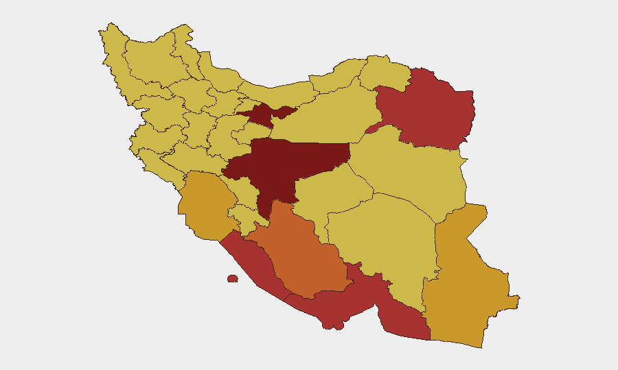
Tehran Province (risk 100) remains the highest-ranked sub-national zone, though the immediate operational crisis is concentrated in southern and southwestern coastal provinces. Bushehr, Hormozgan, and Sistan and Baluchestan provinces—all scoring 72–78 on composite risk—are experiencing direct strike activity, air defense operations, and confirmed casualties; Khuzestan (72.8) and Razavi Khorasan (78.4) are also active zones. Southern provinces represent the convergence of U.S. military targeting (maritime, missile, drone infrastructure) and Iranian retaliatory capability, making them highest-priority for duty-of-care teams with personnel or assets in those regions.
How GeoBit Would Assist
Security and risk teams would employ AOI Monitoring & Early Warning on high-risk southern provinces (Bushehr, Hormozgan, Sistan and Baluchestan, Khuzestan) to detect strike activity, air defense activation, and civilian impact in real time. Satellite & Imagery Analysis combined with Conflict & Military force-tracking capabilities would monitor Parchin hardening efforts and broader Iranian defensive positioning. Routing & Network Analysis would support alternative travel and supply-chain planning for personnel and assets in strike-affected zones.
7-Day Outlook
Further U.S. strikes on Iranian military infrastructure remain probable if maritime or drone threat activity resumes; Iranian retaliation—either via proxy, direct missile, or asymmetric means—is also a material risk. Southern provinces will remain highest-priority zones for monitoring; corporate and duty-of-care teams should expect continued air defense activity and potential civilian disruption through at least mid-week, with de-escalation trajectory unclear.
Highest-Risk Areas — Ranked
| # | State / Region | Risk |
|---|---|---|
| 1 | Tehran Province | 100 |
| 2 | Isfahan Province | 88.8 |
| 3 | Razavi Khorasan | 78.4 |
| 4 | Bushehr Province | 78 |
| 5 | Hormozgan Province | 76.7 |
| 6 | Fars Province | 73.5 |
| 7 | Khuzestan Province | 72.8 |
| 8 | Sistan and Baluchestan Province | 72.1 |
| 9 | Mazandaran Province | 70.8 |
| 10 | Qom Province | 70.7 |
| 11 | East Azerbaijan Province | 70.6 |
| 12 | Yazd Province | 70.5 |
Sources
Previous Daily Briefs
A new Iran brief is written every day — each with its own risk map and downloadable CSV. Here's the last week; use the calendar to go further back.
📅 Browse every day by calendar →
Highlighted days have a brief. Tap a day for that day's map & analysis, or “csv” for that day's dataset ($5).
Atlas — our AI intelligence desk — emails them this snapshot personally. Nothing else, no list.