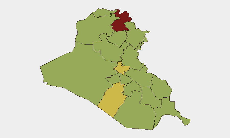
Situation Summary
Iraq remains at composite threat level 77 (global rank #14), characterized by elevated kinetic activity concentrated in the Kurdistan Region and ongoing cross-border hostilities involving Iranian and Israeli military forces. The past 48 hours have seen renewed drone interception operations over Erbil and intensified aerial weapons activity across northern Iraq, though casualties and major infrastructure damage remain limited. The broader risk trajectory reflects sustained tension between US–Iran military posturing, Iraqi government capacity constraints, and localized armed group activity across southern and central governorates.
Key Developments
- Erbil Governorate, July 24 (0800 local approx.): US-led forces intercepted and destroyed five explosive-laden drones in airspace over Erbil, where forward-deployed US military personnel are based. No casualties or significant damage reported; incident attributed to ongoing Iranian drone operations targeting US installations.
- Erbil & Sulaymaniyah Airports, July 23–24: Intensified aerial weapons activity and drone interceptions triggered temporary air-traffic suspensions at both regional airports; flight resumption status remains under review as of early July 24.
- Islamic Resistance in Iraq Statement, July 24: An armed group claiming to represent "Islamic Resistance in Iraq" issued a communiqué alleging five operations against "US military bases across the region" within the preceding 24 hours; specific Iraqi locations and corroboration of claimed incidents remain unconfirmed in open reporting.
- Kirkuk Air Base (K-1), July 23–24 (date uncertain): Executive Iraq reporting indicates a fire incident at K-1 with unknown cause and damage assessment ongoing; precise date and casualty figures not yet confirmed in secondary sources.
- Broad Regional Context (ongoing since mid-July): Artillery, drone, and unmanned aerial vehicle activity has intensified across the Iraq–Iran border and within Iraqi airspace, linked to wider Israeli–Iranian hostilities. Iraqi armed forces have conducted internal security operations in southern governorates.
Highest-Risk Areas
Erbil Governorate (risk 84.1) is the single highest-risk zone, driven by its status as a major US military presence hub, proximity to Iran, and current intensity of cross-border drone and aerial activity. Al-Najaf and Baghdad Governorates (risk 65.7 and 65.6 respectively) remain elevated owing to ongoing armed group activity, political instability, and protest activity linked to internal governance disputes. The remaining southern and central governorates (Dhi Qar, Babil, Wasit, and others, all clustered at risk 54.1) face persistent lower-level armed group presence, criminal activity, and occasional intercommunal tensions, but are not currently experiencing acute kinetic escalation. The risk gradient is driven by proximity to Iran, US military footprint, and the concentration of Popular Mobilization Forces and Iranian-linked militias in the south.
How GeoBit Would Assist
Security and duty-of-care teams should employ GeoBit's AOI Monitoring & Early Warning capability to establish persistent alerts on Erbil, Baghdad, and southern governorates for drone activity, military movements, and protest signals. Cross-reference live Intel Sweep and conflict event feeds with network & actor analysis to track Iranian proxy operations and US–Iraq military coordination. Use GIS & spatial analysis and satellite imagery to monitor airfield status (Erbil, Sulaymaniyah, K-1) and assess infrastructure damage or closures affecting personnel mobility.
7-Day Outlook
Drone and aerial weapons activity is likely to persist in the Kurdistan Region and over US installations through the near term, with periodic interceptions and temporary air-traffic disruptions expected. Iraqi government efforts to maintain internal security and manage cross-border tensions will continue, but without significant de-escalation signals from regional actors. Personnel and asset security posture in Erbil, Baghdad, and southern governorates should remain elevated, with contingency plans for airfield closures and movement restrictions.
Highest-Risk Areas — Ranked
| # | State / Region | Risk |
|---|---|---|
| 1 | Erbil Governorate | 84.1 |
| 2 | Al-Najaf Governorate | 65.7 |
| 3 | Baghdad Governorate | 65.6 |
| 4 | Dhi Qar Governorate | 54.7 |
| 5 | Babil Governorate | 54.1 |
| 6 | Wasit Governorate | 54.1 |
| 7 | Al-Qadisiyah Governorate | 54.1 |
| 8 | Al-Muthanna Governorate | 54.1 |
| 9 | Maysan Governorate | 54.1 |
| 10 | Al-Basra Governorate | 54.1 |
| 11 | Al-Anbar Governorate | 54.1 |
| 12 | Saladin Governorate | 54.1 |
Sources
Previous Daily Briefs
A new Iraq brief is written every day — each with its own risk map and downloadable CSV. Here's the last week; use the calendar to go further back.
📅 Browse every day by calendar →
Highlighted days have a brief. Tap a day for that day's map & analysis, or “csv” for that day's dataset ($5).
Atlas — our AI intelligence desk — emails them this snapshot personally. Nothing else, no list.