Situation Summary
Lebanon faces elevated military and border-security risk, with Israel conducting multiple strikes and reconnaissance operations across southern Lebanon on 31 July–1 August 2026. Nabatieh and South Governorates are experiencing the highest incident density, while Beirut remains exposed to air incursions and psychological pressure operations. The threat trajectory remains steep; escalation drivers—Israeli military activity, Hezbollah positioning, and UN-monitored border dynamics—show no signs of de-escalation.
Key Developments
- Kfar Kila, Marjayoun District (31 July): Israeli forces reported killing an armed militant at the southern security fence; incident flagged as fresh breach-risk indicator along the border zone.
- Aita al-Shaab, Bint Jbeil District (31 July): Confirmed Israeli drone strike on suspected Hezbollah observation point; precision strike corroborated across Israeli and pro-Hezbollah sources.
- Wadi al-Hujayr, between Nabatieh & Marjayoun (31 July): Israeli artillery shelling reported with geolocated video evidence of indirect fire; civilian-use rural roads affected.
- Tayr Harfa & Majdal Zoun, Tyre District (31 July): Overnight Israeli strikes reported on suspected Hezbollah infrastructure; agricultural damage and temporary road closures documented.
- Beirut southern suburbs (Dahieh) (31 July, late evening): Low-altitude Israeli aircraft overflights and sonic boom triggered panic and traffic disruption; no casualties confirmed but consistent with intimidation-operation pattern.
- Naqoura–Rmeish corridor, South Governorate (31 July, late): Increased Israeli reconnaissance drone activity; sporadic small-arms fire from Lebanese side; UNIFIL positions monitoring contained tension.
- Beirut–Damascus Highway, Chtaura area, Beqaa (31 July): Lebanese security forces established temporary checkpoints and intensified inspections following unspecified threat; no clashes reported but road delays occurred.
- Aadloun coastal area, South Governorate (31 July): Israeli naval units moved closer to shore; Lebanese fishing zone temporarily closed; confirmed "increased naval presence" by Lebanese security sources.
Highest-Risk Areas
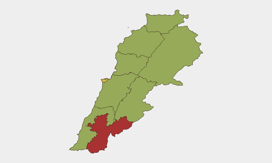
Nabatieh Governorate (77.7) and South Governorate (47.7, but highest incident concentration) drive the composite threat score; both are contiguous with Israel and hosting suspected Hezbollah infrastructure targeted in current strikes. Beirut (66.9) remains vulnerable to air incursions and psychological operations, while northern and eastern governorates (North, Akkar, Baalbek-Hermel, Beqaa) register elevated baseline risk tied to broader Syria-Iraq border instability and cross-border militant activity. The southern concentration reflects the primary driver of Lebanon's global #21 ranking: military strikes and border-fence incidents.
How GeoBit Would Assist
Corporate security teams with personnel or assets in Lebanon should activate AOI Monitoring & Early Warning for Nabatieh and South Governorates to detect further strike activity and movement patterns in real time. Intel Sweep and multi-language OSINT fusion across X, Lebanese local media, and Hezbollah-affiliated channels enable near-real-time corroboration of incident claims and force-posture changes. Routing & Network Analysis and GIS & Spatial Analysis support alternative-route planning for staff in Beirut and the Beqaa, enabling avoidance of checkpoint clusters and active strike zones.
7-Day Outlook
Israeli military pressure is likely to persist; further drone and artillery strikes in Nabatieh, South, and border-adjacent areas should be expected. Hezbollah's response posture and any escalatory signaling will be critical indicators; monitored rhetoric and claimed retaliatory readiness may precede wider conflict. Corporate teams should assume heightened air activity over Beirut and volatility on main highways through 7 August pending de-escalatory statements or operational pauses.
Highest-Risk Areas — Ranked
| # | State / Region | Risk |
|---|---|---|
| 1 | Nabatieh Governorate | 77.7 |
| 2 | Beirut Governorate | 66.9 |
| 3 | North Governorate | 47.7 |
| 4 | Akkar Governorate | 47.7 |
| 5 | Keserwan-Jbeil Governorate | 47.7 |
| 6 | Mount Lebanon Governorate | 47.7 |
| 7 | South Governorate | 47.7 |
| 8 | Beqaa Governorate | 47.7 |
| 9 | Baalbek-Hermel Governorate | 47.7 |
Sources
Previous Daily Briefs
A new Lebanon brief is written every day — each with its own risk map and downloadable CSV. Here's the last week; use the calendar to go further back.
📅 Browse every day by calendar →
Highlighted days have a brief. Tap a day for that day's map & analysis, or “csv” for that day's dataset ($5).
Atlas — our AI intelligence desk — emails them this snapshot personally. Nothing else, no list.