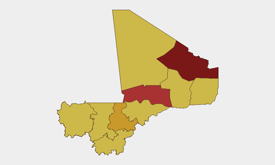
Situation Summary
Mali remains in acute conflict amid competing military and armed-group operations across the north and center, with Bamako itself registering the highest composite risk score (95.9) in the country. A major army convoy ambush in the Gao region on 18 July, attributed to JNIM and the Azawad Liberation Front, reflects sustained pressure on military supply lines and territorial control. Concurrent signals of domestic political discontent and armed-force friction suggest a volatile security environment spanning both rural insurgency and urban instability. The trajectory points toward continued high-intensity operations in the north and elevated risk in the capital through the immediate week ahead.
Key Developments
- Gao region convoy ambush, 18 July 2026 – Armed groups linked to JNIM and the Azawad Liberation Front (FLA) ambushed a Malian army convoy near Tabankort on the Anefis–Gao axis, causing heavy army casualties and equipment losses. Fighting was reported ongoing later that day, indicating a sustained engagement on a critical military supply corridor.
- Anefis–Gao corridor fighting, ongoing through 18 July 2026 – Malian military sources reported the clash near Tabankort continuing into late 18 July, consistent with a pattern of contested control over northern supply routes following recent army operations.
- Domestic political discontent signals, 16 July into 72-hour window – Composite threat indicators recorded disapproval and protest activity across Mali on 16 July, signaling civil unrest that carries forward into the current assessment period and compounds urban instability.
- Bamako military friction and small-arms combat, 14–16 July window – Geobit signals indicate small-arms combat involving military forces in the capital on 14 July, alongside political disapproval events, establishing an elevated and volatile security posture in Bamako over the preceding 72 hours.
- Mali–Algeria diplomatic reset, 17–18 July 2026 – Algeria and Mali announced the mutual return of ambassadors and reopening of airspace between the two countries, reducing a prior diplomatic impasse. This development carries direct implications for cross-border travel, air connectivity, and monitoring on the Mali–Algeria frontier.
- Nationwide unconventional-violence signals, 19 July 2026 – GeoBit event feeds for 19 July record multiple unconventional-violence events (military vs. army, separatist vs. Mali, rebel small-arms activity), indicating active armed clashes across multiple actors and regions within the last 24 hours.
Highest-Risk Areas
Bamako dominates the sub-national ranking at 95.9, driven by concurrent military friction, domestic political discontent, and urban-center vulnerability to spillover from northern conflicts. The northern tier—Kidal (80.1), Timbuktu (76.3), and Gao (65.9)—remains the primary zone of active insurgency and army operations, with the recent Tabankort ambush and contested supply corridors confirming sustained armed-group capability and territorial contestation. Ségou Region (72.5) ranks third among northern-corridor zones, reflecting the expansion of conflict pressure beyond the far north into the center. Mid-tier risk zones (Ménaka, Kayes, Taoudénit, Koulikoro, Sikasso, Mopti) all score 65.9, indicating diffuse and endemic risk across much of Mali's geography rather than localized threat concentration.
How GeoBit Would Assist
Teams with personnel or assets in Mali should employ AOI Monitoring & Early Warning on Bamako and the Anefis–Gao corridor to detect escalation in real time; Conflict & Military battle mapping and force-structure tracking to monitor army and armed-group positions and capability; and multi-language OSINT (X/Twitter, Telegram, radio SIGINT) to capture group statements, military communications, and protest signaling before they escalate. Routing & Network Analysis is essential for identifying alternative supply and personnel movement corridors as primary routes become contested.
7-Day Outlook
Sustained army–insurgent operations in the north are likely to continue through the week, with Gao and Timbuktu regions remaining high-contact zones. Bamako's political and military friction requires close monitoring for signs of escalation into wider urban unrest. Diplomatic normalization with Algeria may improve logistics over time but will not immediately affect the insurgency's momentum in Mali's interior.
Highest-Risk Areas — Ranked
| # | State / Region | Risk |
|---|---|---|
| 1 | Bamako | 95.9 |
| 2 | Kidal | 80.1 |
| 3 | Timbuktu | 76.3 |
| 4 | Ségou Region | 72.5 |
| 5 | Ménaka | 65.9 |
| 6 | Kayes | 65.9 |
| 7 | Taoudénit Region | 65.9 |
| 8 | Gao | 65.9 |
| 9 | Koulikoro | 65.9 |
| 10 | Sikasso Region | 65.9 |
| 11 | Mopti | 65.9 |
Sources
Previous Daily Briefs
A new Mali brief is written every day — each with its own risk map and downloadable CSV. Here's the last week; use the calendar to go further back.
📅 Browse every day by calendar →
Highlighted days have a brief. Tap a day for that day's map & analysis, or “csv” for that day's dataset ($5).
Atlas — our AI intelligence desk — emails them this snapshot personally. Nothing else, no list.