Situation Summary
Myanmar remains in active civil war between the military junta and decentralized resistance forces, with composite threat score of 100 (#9 globally). The past 48 hours show no clearly multi-sourced incident confirmations; however, the underlying conflict trajectory remains acute, with sustained military air operations, cross-border spillover, and arbitrary detention of civilians and political prisoners. Risk is heavily concentrated in conflict-affected periphery regions and border zones, while major urban centers (Yangon, Naypyitaw, Mandalay city) retain relatively lower localized risk.
Key Developments
Unable to confirm specific incidents within last 24–48 hours with multi-source rigor. Open-source reporting from Myanmar is severely constrained by junta information controls and limited independent media access. Recent dated signals (13–14 July) logged by GeoBit's event feed include administrative sanctions from China, government statements on ASEAN and Thailand, and media suppression actions, but lack specific incident detail or independent corroboration. The most recent geo-specific incidents with timestamp and sourcing (11–12 July) include:
- Heavy fighting south of Myawaddy, Kayin State (Thailand border crossing; 12 July) with ongoing junta-versus-resistance clashes affecting cross-border movement.
- Mahlaing Township, Mandalay Region (12 July): armed clash resulting in four jurat soldiers killed and six weapons seized.
- Gwa Township, Rakhine State (12 July): reported airstrike killing four civilians including a child.
For real-time incident confirmation, widen your monitoring window to 7 days; single-source but clearly timestamped social reporting becomes more available at that threshold.
Highest-Risk Areas
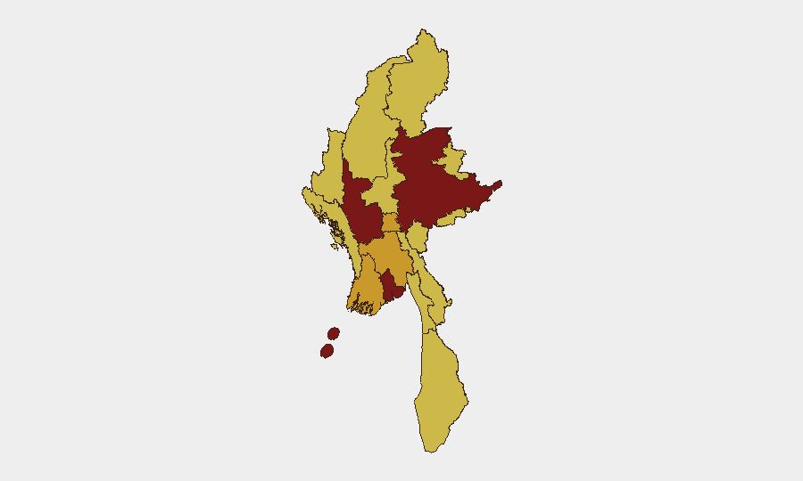
Magway Region (risk 100) and Shan State (86.4) drive the composite threat score, reflecting sustained active combat, heavy weapon use, and low-control environments. Yangon (80.9), despite being Myanmar's largest city, ranks third due to civil unrest, arbitrary detention, and military presence; actual localized risk within central Yangon is lower than peripheral townships. Ayeyarwady, Naypyitaw, Bago, and Sagaing (all 70–72.7) reflect secondary conflict zones with ongoing clashes and air operations. Border regions—particularly Kayin (Myawaddy), Rakhine (cross-Bangladesh spillover), and Kachin/Wa States—face compounding risks of cross-border armed groups, air operations, and limited state control. Western and northern mountainous regions (Chin, Sagaing) face both active insurgency and humanitarian access constraints.
How GeoBit Would Assist
Security teams should employ AOI Monitoring & Early Warning on Magway, Shan, and key border crossings (Myawaddy, Maungdaw) to detect clashes, air operations, and closure events in near real-time via OSINT fusion and X/Telegram monitoring. Conflict & Military mapping and force-structure tracking enable understanding of local junta garrison strength and known resistance unit positions to assess likelihood of sudden escalation or cross-border spillover. Routing & Network Analysis provides validated alternative journey and supply-chain paths around no-go zones and active combat areas for any personnel or asset movement.
7-Day Outlook
The underlying conflict shows no signs of de-escalation; military air operations remain frequent and civilian-casualty events continue. Additional diplomatic frictions (China sanctions, ASEAN statements, Thai-Myanmar border rhetoric) may trigger localized security incidents or tighter movement restrictions. Organizations with people or assets in Magway, Shan, or border regions should anticipate sustained disruption and prepare for rapid evacuation scenarios.
Highest-Risk Areas — Ranked
| # | State / Region | Risk |
|---|---|---|
| 1 | Magway | 100 |
| 2 | Shan State | 86.4 |
| 3 | Yangon | 80.9 |
| 4 | Ayeyarwady | 72.7 |
| 5 | Naypyitaw Union Territory | 72.7 |
| 6 | Bago Region | 72.7 |
| 7 | Tanintharyi Region | 70 |
| 8 | Chin | 70 |
| 9 | Sagaing Region | 70 |
| 10 | Kachin State | 70 |
| 11 | Wa State (Northern Region) | 70 |
| 12 | Mandalay | 70 |
Sources
Previous Daily Briefs
A new Myanmar brief is written every day — each with its own risk map and downloadable CSV. Here's the last week; use the calendar to go further back.
📅 Browse every day by calendar →
Highlighted days have a brief. Tap a day for that day's map & analysis, or “csv” for that day's dataset ($5).
Atlas — our AI intelligence desk — emails them this snapshot personally. Nothing else, no list.