Situation Summary
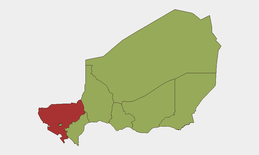
Niger remains at composite threat rank #24 globally (score 67), with Tillabéri Region significantly elevated above other zones due to sustained terrorist operational activity. The 17 July 2026 Téra attack in Tillabéri—which killed 16 Nigerien soldiers and resulted in 15 confirmed attacker casualties—has triggered ongoing security force sweep operations through 19 July, but professional monitoring reports no newly corroborated discrete incidents nationwide in the 24–48 hours following. The threat environment reflects persistent but localized terrorist pressure rather than nationwide destabilization or escalation at this time.
Key Developments
- Téra area, Tillabéri Region (17 July attack; operations ongoing 18–19 July): Terrorist ambush on Bankilaré–Téra axis near Doungouro killed 16 soldiers, wounded 23 (9 seriously). Security forces killed 15 attackers and seized/destroyed multiple motorcycles. Follow-on search and sweep operations continued through 19 July with no newly reported discrete incidents nationwide in the subsequent surveillance cycle.
- Government demonstration, Niamey (20 July): Demonstrate/Rally event flagged in government-directed activity; context and scale require ongoing monitoring but no mass unrest or violence corroborated in open sources.
- Ghana–Niger diplomatic incident (20 July): Ghana issued threat communication toward Niger; nature and follow-on trajectory remain unclear from available reporting. Warrants continued diplomatic watch but does not indicate imminent military escalation.
- Administrative sanctions, Niger Delta (19 July): Governance or regulatory action flagged; insufficient detail in current reporting to assess operational impact on commerce or humanitarian access.
- Continued security operations (20 July): Niger Defense and Security Forces mounted conventional military operations in response to ongoing terrorist activity; operations tempo consistent with post-attack response rather than indicating new territorial loss or cascade incidents.
Highest-Risk Areas
Tillabéri Region (risk score 77.2) is the primary driver of national risk, hosting the Téra corridor and the broader Bankilaré-Doungouro zone where the 17 July attack occurred. Agadez, Zinder, and Diffa regions cluster at 47.2, reflecting endemic terrorist activity across Niger's northern and eastern borderlands; Niamey (47.2) reflects capital-city political volatility and demonstration activity. Dosso, Maradi, and Tahoua at 47.2 indicate distributed but lower operational intensity. Risk concentration in Tillabéri underscores that terrorist threat remains geographically specific rather than nationwide, though the northern and eastern frontier zones warrant sustained attention for cross-border activity and ungoverned-space operations.
How GeoBit Would Assist
Security and risk teams with personnel or assets in Niger should deploy AOI Monitoring & Early Warning on Tillabéri, Agadez, Zinder, and Diffa regions to capture emerging attack patterns and military operations in near-real time. Battle Mapping and Force Structure analysis applied to confirmed terrorist positions and Nigerien military response geometry enables route-planning and asset-positioning decisions. Network & Actor Analysis paired with OSINT fusion (X/Telegram monitoring, multi-language event feeds, sentiment analysis) provides 48–72 hour early warning of attack preparation, group movement, or political instability ahead of corporate security decisions on staff movement or access control.
7-Day Outlook
No imminent nationwide escalation is indicated, but Tillabéri and the northern corridor remain high-tempo operational zones. Ongoing military sweep operations may suppress immediate attack probability in the Téra sector over the next 3–5 days, though terrorist re-positioning to alternative axes (Agadez, Zinder routes) cannot be ruled out. Diplomatic friction between Ghana and Niger and domestic political activity warrant monitoring for secondary effects on border stability or capital security posture.
Highest-Risk Areas — Ranked
| # | State / Region | Risk |
|---|---|---|
| 1 | Tillabéri Region | 77.2 |
| 2 | Agadez Region | 47.2 |
| 3 | Zinder Region | 47.2 |
| 4 | Diffa Region | 47.2 |
| 5 | Niamey | 47.2 |
| 6 | Tahoua Region | 47.2 |
| 7 | Dosso Region | 47.2 |
| 8 | Maradi Region | 47.2 |
Sources
Previous Daily Briefs
A new Niger brief is written every day — each with its own risk map and downloadable CSV. Here's the last week; use the calendar to go further back.
📅 Browse every day by calendar →
Highlighted days have a brief. Tap a day for that day's map & analysis, or “csv” for that day's dataset ($5).
Atlas — our AI intelligence desk — emails them this snapshot personally. Nothing else, no list.